French Polynesia Coral Reef Maps — Society Islands Lagoons & Tuamotu Atolls
French Polynesia’s coral reefs are spread across 118 islands and atolls in five archipelagos in the South Pacific. The high volcanic Society Islands, including Tahiti, Moorea and Bora Bora, are ringed by barrier reefs enclosing famous turquoise lagoons. The Tuamotu Archipelago to the east is one of the largest groups of coral atolls on Earth, with around 76 atolls such as Rangiroa and Fakarava. The Gambier, Austral and Marquesas islands add more reefs further out. Global mapping by UNEP-WCMC records roughly 3,000 km² of coral reef in French Polynesia. The map below focuses on the Society Islands and the western Tuamotus, the heart of the territory’s coral.
French Polynesia covers an area of ocean about as wide as Europe, yet its total land area is small. Almost everything about the territory, from its beaches and food to its economy and culture, depends on coral. Few places show the full life story of a Pacific reef island so clearly: young volcanic islands with fringing reefs, older islands with barrier reefs and lagoons, and atolls where the volcano has disappeared entirely. This page explains where French Polynesia’s reefs are, how to read the map, what lives there and the pressures they face.
Where are French Polynesia’s coral reefs on the map?
The map shows the two great reef landscapes of French Polynesia: barrier-reef islands in the Society group and rings of atolls in the Tuamotus.
In the west, the Society Islands include Tahiti and Moorea (the Windward Islands) and Bora Bora, Raiatea, Taha’a, Huahine and Maupiti (the Leeward Islands), each a volcanic island inside a barrier reef. North-east of them, the Tuamotu Archipelago stretches across a huge area of ocean as a chain of low coral atolls, with lagoons ranging from small ponds to inland seas.
Beyond the map’s edges lie the Gambier Islands in the south-east, a group of high islands inside a large lagoon; the Austral Islands in the south, at the cooler edge of the reef zone; and the Marquesas in the north-east, steep volcanic islands with limited reef development because of their exposed coasts and cooler, nutrient-rich water.
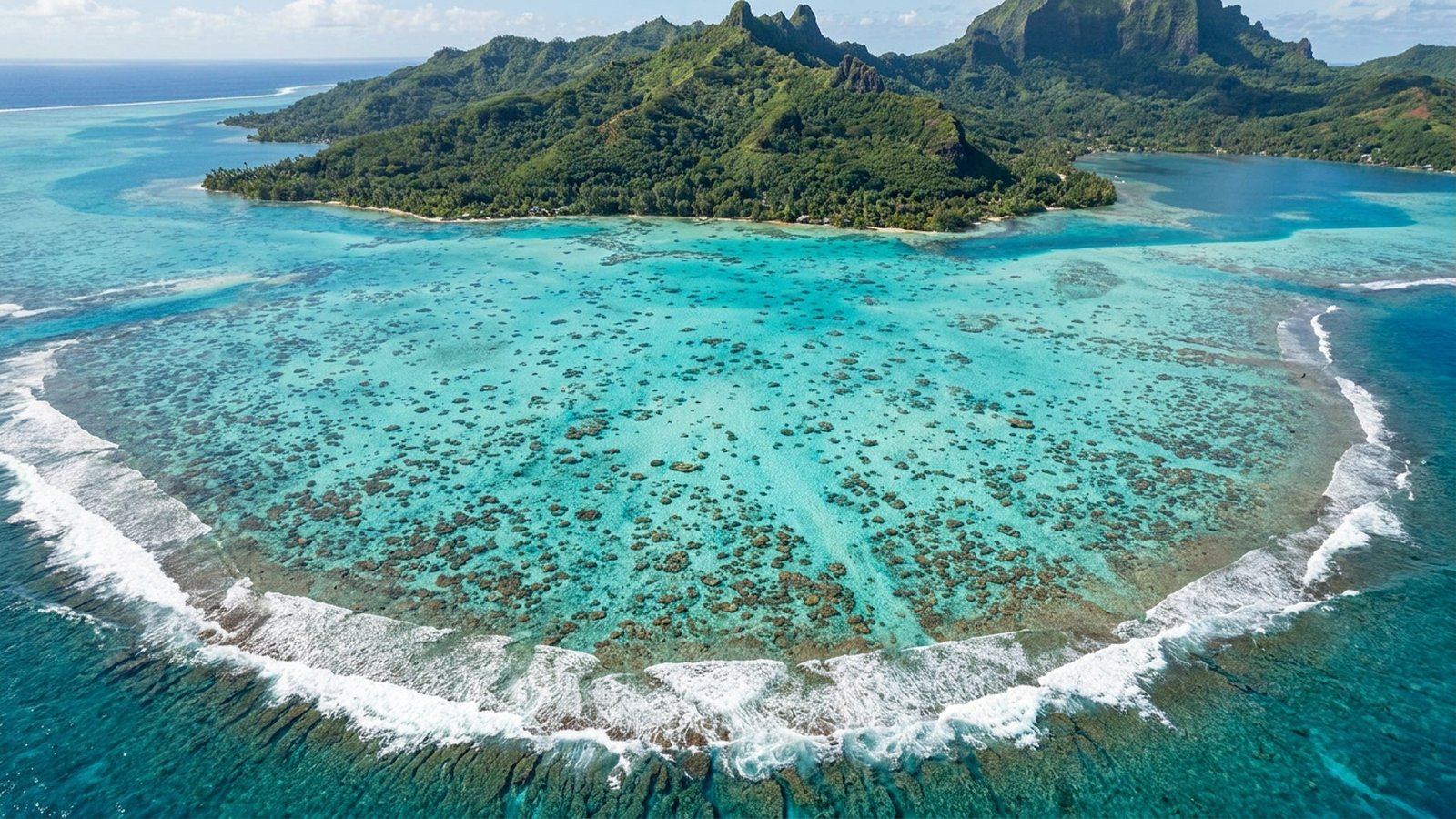
The Society Islands: Tahiti, Moorea and Bora Bora lagoons
The Society Islands are the classic South Seas picture: green volcanic peaks inside turquoise lagoons, enclosed by barrier reefs.
Each high island is the eroded remains of a volcano. As the islands slowly subsided, coral kept growing upward on the reef around them, leaving lagoons between reef and shore. Bora Bora shows this stage perfectly, with its central peaks surrounded by a wide lagoon and a ring of reef islets, or motu. Maupiti, further west, is older still and closer to becoming an atoll. Read more about barrier reefs and the difference between barrier reefs and atolls.
Moorea is one of the most studied reefs in the world. French and American research stations on the island have monitored its reefs for decades, recording how they were stripped by a crown-of-thorns starfish outbreak and a cyclone around 2010 and then recovered coral cover surprisingly quickly. Tahiti’s reefs are more affected by its larger population, but surf breaks such as Teahupo’o are world famous, and Tahiti’s lagoon hosts diverse coral and fish.
The Tuamotu atolls: Rangiroa and Fakarava
The Tuamotus are reef in its purest form: rings of coral and coral rubble with no volcanic rock left above the sea.
Each Tuamotu atoll is the coral cap on a long-sunken volcano. Narrow strips of land along the reef rim enclose lagoons that connect to the ocean through passes. Rangiroa is one of the largest atolls in the world, with a lagoon so wide that its far side lies over the horizon. Fakarava and the surrounding atolls form a UNESCO Biosphere Reserve.
The passes, where tides pour water in and out of the lagoons, are among the world’s great dive sites. At Rangiroa’s Tiputa Pass divers see dolphins, grey reef sharks and great hammerheads in season. In Fakarava’s south pass, scientists have documented hundreds of grey reef sharks gathering each year around a large spawning aggregation of camouflage groupers, one of the densest concentrations of reef sharks known. On land, life on the atolls is lived entirely on coral, with no higher ground and fresh water scarce.
What marine life lives on French Polynesia’s reefs?
Sharks, rays, turtles and dense schools of reef fish, with whales offshore in the southern winter.
French Polynesia’s reefs have fewer coral and fish species than the reefs of the western Pacific, because they lie far from the Coral Triangle, but they make up for it in abundance. Divers see blacktip, whitetip, grey reef and lemon sharks, manta and eagle rays, green and hawksbill turtles, Napoleon wrasse, moray eels, parrotfish, surgeonfish and huge schools of snappers and jacks. Humpback whales arrive from Antarctic waters to breed around the islands roughly from July to November.
French Polynesia has protected sharks throughout its waters for more than a decade, and much of its huge exclusive economic zone has been designated as a managed marine area. Traditional rahui, temporary closures of reefs or lagoons to fishing, have been revived in several communities to let stocks recover. See our guide to coral reef fish.
Reefs, black pearls and people
Tourism, pearl farming and fishing all depend on clean lagoons and living coral.
The calm, reef-enclosed lagoons of the Tuamotus and Gambiers are the home of the Tahitian black pearl, farmed from the black-lip pearl oyster and one of the territory’s main exports. Pearl farms need clean water and healthy lagoon ecosystems, so they have a direct stake in reef health. Tourism, centred on the Society Islands but extending to dive resorts on the atolls, is the largest part of the economy, and lagoon fisheries feed island communities.
Polynesian culture is woven together with the reef and the sea, from traditional navigation and canoe voyaging to fishing knowledge and legend. That connection is one reason community-led management, such as rahui, has found strong support.
Threats to French Polynesia’s coral reefs
Bleaching, crown-of-thorns outbreaks, coastal development and sea-level rise are the main pressures.
Marine heatwaves have caused significant coral bleaching in French Polynesia, including a severe event in 2019. Outbreaks of coral-eating crown-of-thorns starfish have repeatedly stripped coral from reefs such as Moorea’s, and cyclones can break reefs apart. Around Tahiti and the busiest islands, coastal construction, runoff and sewage add local stress, while on the atolls, sea-level rise and storm surges threaten islands that rise only a few metres above the sea.
There are encouraging signs. Long-term monitoring on Moorea shows that well-connected reefs with healthy fish populations can recover remarkably quickly after disturbance, and shark protection and rahui help keep reef food webs intact. Learn more in our coral reef conservation pages and can coral reefs recover from bleaching?
Does French Polynesia have coral reefs?
Yes, extensive ones. Barrier reefs and lagoons surround the Society Islands, and the Tuamotu Archipelago is one of the largest groups of coral atolls in the world. UNEP-WCMC maps about 3,000 km² of reef.
Is there a coral reef in Bora Bora?
Yes. Bora Bora is surrounded by a barrier reef with a ring of islets (motu) that encloses its famous lagoon. Coral gardens in the lagoon are popular for snorkelling.
How many atolls are in the Tuamotus?
Around 76, making the Tuamotu Archipelago one of the largest chains of coral atolls on Earth. Rangiroa and Fakarava are the best known.
Where is the best diving in French Polynesia?
The passes of the Tuamotu atolls, especially Rangiroa’s Tiputa Pass and Fakarava’s south pass, are famous for sharks and big fish. Moorea and Bora Bora offer easier lagoon and reef dives.
Are sharks protected in French Polynesia?
Yes. Sharks are protected throughout French Polynesia’s waters, which helps explain the large numbers seen on dives in the Tuamotus.
When can you see humpback whales in French Polynesia?
Usually from about July to November, when humpbacks come to breed and calve around islands such as Moorea, Tahiti and Rurutu.
What threatens French Polynesia’s coral reefs?
Marine heatwaves and bleaching, crown-of-thorns starfish outbreaks, cyclones, coastal development around Tahiti, and sea-level rise on the low atolls.
- UNEP-WCMC, WorldFish Centre, WRI, TNC (2021). Global distribution of warm-water coral reefs, v4.1.
- UNESCO Man and the Biosphere Programme: Fakarava (Commune de Fakarava) Biosphere Reserve.
- Moorea Coral Reef Long-Term Ecological Research site and CRIOBE monitoring of Moorea’s reefs.
- Mourier, J. et al. (2016). Extreme inverted trophic pyramid of reef sharks supported by spawning groupers. Current Biology.
Blane Perun has been exploring Earth’s oceans and marine life for over 25 years. Founder of TheSea.Org in 1999, underwater photographer, coral aquaculture pioneer, and explorer of 80+ countries.
About Blane Perun → More Coral Reef Maps →