Thonis-Heracleion — Egypt’s Great Port, Lost Beneath Abu Qir Bay
Thonis-Heracleion was ancient Egypt’s principal Mediterranean port from roughly the 6th to the 4th century BC, before Alexandria eclipsed it. Thonis was its Egyptian name and Heracleion its Greek one. The city sank into what is now Abu Qir Bay, about 6.5–7 km off the coast and roughly 6–10 m deep, through earthquakes, rising sea level and the liquefaction of its clay foundations. It was rediscovered in 2000 by French underwater archaeologist Franck Goddio and the European Institute for Underwater Archaeology (IEASM).
For centuries Thonis-Heracleion was known only from a few lines in Herodotus and the decree inscriptions of Egyptian pharaohs. Some scholars suspected Thonis and Heracleion were two different places. Then, in 2000, Franck Goddio’s team found the city itself, buried in sediment on the floor of Abu Qir Bay.
Where was Thonis-Heracleion?
At the mouth of the Canopic branch of the Nile, about 32 km north-east of modern Alexandria, now 6.5–7 km offshore under roughly 6–10 m of water.
Its location made it the gateway to Egypt for Greek and Mediterranean trade. All ships arriving from the Greek world had to pass through its customs post. Canals linked the city to the Nile and to the nearby city of Canopus, also now underwater.
| Date | Event |
|---|---|
| ~6th century BC | Thonis-Heracleion flourishes as Egypt’s gateway port |
| ~450 BC | Herodotus mentions a temple of Heracles at the Canopic mouth |
| 380 BC | Pharaoh Nectanebo I’s decree stele set up at Thonis |
| 331 BC | Alexandria founded; trade gradually shifts there |
| ~2nd century BC | Much of the city collapses into the sea |
| 8th century AD | Last parts of the area submerged |
| 2000 | Goddio and IEASM rediscover the city |
| 2016 | Major finds exhibited at the British Museum (‘Sunken Cities’) |
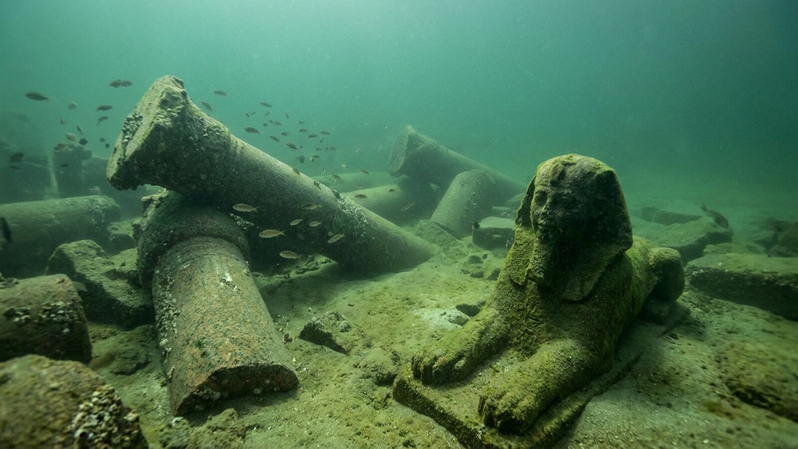
What has been found at Thonis-Heracleion?
Highlights include three colossal red granite statues of a Ptolemaic king, queen and the Nile flood god Hapy, each about 5 m tall; the black granite Stele of Thonis-Heracleion, a near-twin of the Naukratis stele, which confirmed that Thonis and Heracleion were the same place; the remains of the great temple of Amun-Gereb; gold jewellery, coins and ritual objects; and roughly 70 ancient shipwrecks and more than 700 anchors, the largest concentration of ancient ships ever found in one place.
Why did Thonis-Heracleion sink?
The city was built on soft Nile delta clay and silt. A combination of earthquakes, rising sea levels and soil liquefaction, in which water-saturated sediment suddenly loses strength, caused buildings to collapse and the land to subside. The process seems to have been gradual, with major collapses in the 2nd century BC and later. The same forces submerged parts of Canopus and Alexandria’s royal quarter (see Cleopatra’s palace).
Can you dive Thonis-Heracleion?
No. The site lies in murky water within a protected archaeological zone and excavations are run by IEASM with Egypt’s Ministry of Tourism and Antiquities. Visitors can see major finds in museums, including the Alexandria National Museum, and in touring exhibitions.
What was Thonis-Heracleion like at its height?
Thonis was built across a cluster of islands in the Nile Delta, around a central temple. Canals ran between the islands, and the city had several harbours and anchorages. Wharves, temples and tower-houses were linked by ferries, bridges and pontoons. It was an emporion, a licensed trading port, and by the Late Period it was Egypt’s main gateway for international trade and for collecting customs duties. Its sister port, Naukratis, lay 72 km up the Nile. Goods moved inland either through Naukratis or across the Western Lake and along a canal to nearby Canopus.
The city’s religious life was as important as its trade. A large temple of Khonsu, son of Amun, whom the Greeks identified with Herakles, explains the Greek name. Later the cult of Amun-Gereb dominated, and his great temple stood at the centre of the city during its peak between the sixth and fourth centuries BC. Nectanebo I added to it in the fourth century BC. Sanctuaries of Osiris and other gods were known for miraculous cures and drew pilgrims from far away. Every year, in the month of Khoiak, the Mysteries of Osiris were celebrated. The god was carried in his ceremonial boat in procession from the temple of Amun to his shrine at Canopus. The excavators have found evidence of these rites on the seabed.
How was the stele that solved the puzzle found?
Before 2000, most historians assumed that Thonis and Heracleion were two separate towns, both somewhere on what is now dry land. The key evidence was a decree of Nectanebo I already known from the Stele of Naukratis. It ordered that one-tenth of the taxes on imports passing through Thonis should go to the temple of the goddess Neith at Sais. The decree said a second copy should be set up at Thonis itself. Goddio’s divers found that second copy, a black granodiorite stele, near the temple of Amun-Gereb in what the Greeks called Heracleion. That proved Thonis and Heracleion were the same city.
Other inscriptions add to the picture. The Decree of Canopus, passed by an assembly of priests in 239 BC to honour Ptolemy III and Queen Berenice, mentions the city and describes donations, sacrifices and a procession on water. Three copies of the Canopus decree are known, written in hieroglyphs, demotic and Greek. After the Rosetta Stone, they were the most important texts for deciphering Egyptian writing.
What did Greek writers say about Thonis?
Greek authors connected the city with their own legends. Herodotus, writing around 450 BC, tells how Paris and Helen, fleeing Menelaus, landed at the Canopic mouth of the Nile. Paris’s servants took refuge in a temple of Herakles on the coast and told the priests, and Thonis, the watchman of the river mouth, of the abduction. Thonis seized Paris and his ships and sent the couple to Memphis to be judged by King Proteus. Another version has Menelaus and Helen entertained by a noble Egyptian named Thon and his wife Polydamna. The geographer Strabo wrote that the city took its name from an ancient king called Thonis. Diodorus linked it to a myth in which Herakles stopped a destructive Nile flood. The Hellenistic poet Nicander said that Menelaus’s helmsman, Canopus, died of a viper bite on the sands of Thonis.
Excavations announced in 2023 suggest that Greeks were not just visiting traders. They had started to settle in the city as early as the Twenty-sixth Dynasty, in the seventh and sixth centuries BC, and Greek mercenaries probably helped defend it. A burial mound found in 2021 was covered with offerings from the early fourth century BC. They included wicker baskets of doum-palm fruit and grape seeds, black- and red-figure pottery probably imported from Attica, a wooden banqueting couch and a fine gold amulet. The finds suggest a settled community of Greek merchants and soldiers.
How do archaeologists excavate a city under the sea?
Goddio’s team spent about five years searching before they located the site. They started with ancient texts to narrow down the area. Then they mapped the seabed with a nuclear magnetic resonance magnetometer, which detects tiny magnetic differences in buried material. Multibeam bathymetry, side-scan sonar, a sub-bottom profiler that sees into the sediment, and satellite positioning completed the survey. Excavation follows a grid, and every object is tagged and its position recorded before anything moves. Water dredges remove the sediment layer by layer. Archaeologists work alongside artists and photographers in tightly scheduled seasons of about a month a year.
The team’s policy is to leave objects where they lie unless Egypt’s antiquities authorities approve raising them for conservation or protection. Small finds come up in tagged bags and baskets. Colossal statues are lifted by crane onto the research ship Princess Duda, then cleaned and desalinated so they are not damaged as they dry out after centuries underwater. Goddio estimates that only about 5 percent of the city has been excavated, so excavation will continue for many more seasons.
Why are the shipwrecks so important?
The harbour basins have yielded around 70 ancient ships, the largest deposit of ancient vessels found anywhere, along with hundreds of anchors. They give nautical archaeologists a rare chance to compare building techniques and materials across several centuries.
One of them, Ship 17, solved a puzzle from Herodotus. He described a Nile cargo boat, the baris, built from short, thick planks of acantha (“thorn”) wood laid “like bricks”, tied to long internal stakes, with no ribs and a single rudder passing through the keel. For centuries no example was known. Ship 17, found in 2003, excavated between 2009 and 2011 and up to 28 m long, matched his description closely, including the unusual planking and the axial rudder through the hull. The full study, by Alexander Belov, is published by the Oxford Centre for Maritime Archaeology.
In 2021 the team announced a very different vessel, a Ptolemaic galley about 25 m long. It combined Greek mortise-and-tenon joints with a flat Egyptian bottom suited to the shallow Nile and its delta. It had both sails and oars. It had been moored near the temple of Amun when huge blocks from the collapsing temple fell on it and pinned it to the seabed. That is why it survived.
What other discoveries have been made?
In July 2019 the team reported a tholos, a small round Greek temple, along with granite columns, ships still carrying cargo, and bronze coins of Ptolemy II. On 19 September 2023 IEASM announced the remains of a temple to Amun and a Greek sanctuary of Aphrodite, with Greek weapons among the finds. Other statues include an incomplete figure of Serapis, a statue of Queen Arsinoe II, and a queen, probably Cleopatra II or III, dressed in the tunic of Isis. The colossal Hapy holds a tray of four loaves of bread, symbols of the abundance brought by the Nile flood. Gold coins, jewellery, sarcophagi for sacred animals and much Greek pottery round out the collection.
What else lies under Abu Qir Bay?
Abu Qir Bay covers some 500–600 km² between the Rosetta mouth of the Nile and the town of Abu Qir. It averages only 10–12 m deep. Three ancient towns lie under its water or its shore. Canopus was famous in Roman times for luxury and pleasure, and Seneca and Juvenal both mocked its excesses. Its eastern suburbs collapsed into the sea at the end of the second century BC, and its western suburbs lie under modern Abu Qir. Menouthis was a healing sanctuary of Isis. Christian monks took it over after the temple was closed in the late fourth century, and in the sixth and seventh centuries its shrine of Saints Cyrus and John was one of the two main pilgrimage centres of Christian Egypt.
Between 19 and 21 August 2025, Egypt’s Ministry of Tourism and Antiquities staged a public lift at Abu Qir. Cranes raised artefacts from the Canopus area for the first time in 25 years, including a large quartzite sphinx bearing cartouches of Ramesses II and a white marble statue of a Roman nobleman. Minister Sherif Fathy stressed that only a limited selection is raised under strict criteria, and that the rest stays on the seabed. In December 2025 Goddio’s team also announced a different find in Alexandria’s eastern harbour, near the sunken island of Antirhodos. It is the hull of an oar-powered pleasure boat more than 35 m long, with Greek graffiti probably from the early first century AD, the first such vessel found in Egypt.
The bay has a modern naval history too. On 1 August 1798 Horatio Nelson’s fleet destroyed the French fleet at anchor here in the Battle of the Nile. The French flagship Orient exploded at about 10 p.m. A French team found its wreck in 1983, and Goddio led a larger survey in 1998. He found debris scattered over an area about 500 m across, including gold and silver coins from around the Mediterranean.
Is Thonis-Heracleion still under threat?
The forces that sank the city have not stopped. The soft sediments of the south-eastern Mediterranean coast are prone to liquefaction. Around 101 BC, probably after a severe flood, the clay beneath Heracleion’s central island lost its strength and the buildings collapsed into the water. Today the threat is mostly to the land. Researchers report that parts of Alexandria are subsiding by more than 3 mm a year. Egyptologists warn that continuing sea-level rise now endangers coastal heritage on land as well as the sites already underwater. Goddio’s work has been funded by the Hilti Foundation since 1996, and the Oxford Centre for Maritime Archaeology publishes the excavation reports.
Who is Franck Goddio?
Franck Goddio was born in Casablanca in 1947 and trained in mathematics and statistics in Paris. He worked as an adviser to national and international organisations before turning to underwater archaeology. Before Egypt, he excavated wrecks in the Philippines, including the Spanish galleon San Diego. In Egypt he has led the work at Canopus and at Antirhodos in Alexandria’s ancient Great Harbour as well as at Thonis-Heracleion. He has received the French Legion of Honour, and in 2018 he became a visiting professor in maritime archaeology at Oxford.
Where is Thonis-Heracleion?
In Abu Qir Bay, about 32 km north-east of Alexandria, Egypt, 6.5–7 km offshore and roughly 6–10 m deep.
When did Thonis-Heracleion sink?
Gradually; major collapses occurred around the 2nd century BC and the last areas were submerged by about the 8th century AD.
Who discovered Thonis-Heracleion?
Franck Goddio and the European Institute for Underwater Archaeology in 2000.
Why did Thonis-Heracleion sink?
Earthquakes, sea-level rise and liquefaction of the soft delta sediment it was built on.
Can you visit Thonis-Heracleion?
Not underwater, but many finds are displayed in Egyptian museums and travelling exhibitions.
Is Thonis-Heracleion Atlantis?
No. It is a historically documented Egyptian port; see our Atlantis page for the legend.
- Goddio, F. (2007). The Topography and Excavation of Heracleion-Thonis and East Canopus (1996–2006). Oxford Centre for Maritime Archaeology.
- Robinson, D. & Goddio, F. (eds.) (2015). Thonis-Heracleion in Context. Oxford.
- British Museum (2016). Sunken Cities: Egypt’s Lost Worlds exhibition.
- Wikipedia: Heracleion; Baris (ship); Canopus, Egypt; Menouthis; Abu Qir Bay; Franck Goddio; Battle of the Nile (2023 revisions).
- The Art Newspaper (25 August 2025): underwater artefacts recovered from Canopus, Abu Qir.
- CBS News/AFP (8 December 2025): 2,000-year-old pleasure boat found off Alexandria (Antirhodos).
Blane Perun has been exploring Earth’s oceans and marine life for over 25 years. Founder of TheSea.Org in 1999, underwater photographer, coral aquaculture pioneer, and explorer of 80+ countries.
About Blane Perun →More on Sunken Cities →