Tokelau Coral Reef Maps — Atafu, Nukunonu and Fakaofo
Tokelau consists of just three low coral atolls — Atafu, Nukunonu and Fakaofo — in the central Pacific north of Samoa. Each atoll is a ring of coral reef enclosing a lagoon, with small islets called motu on the reef rim where all of Tokelau’s people live. There is no high land, no airstrip and no other rock: the reefs are the territory. UNEP-WCMC maps roughly 97 km² of reef across the three atolls. Tokelau is a self-administering territory of New Zealand with around 1,500 residents.
Tokelau is one of the most remote inhabited places on Earth and one of the purest examples of a reef-built homeland. Three small rings of coral, a total land area smaller than many city parks, support a close-knit Polynesian community that has lived from the lagoon and reef for centuries. This page maps those three atolls, explains how they work and looks at what the future holds for them.
Tokelau coral reef map
Three small reef rings in a line across open ocean.
On the map, Tokelau’s atolls appear as three separate loops of reef running roughly north-west to south-east: Atafu in the north-west, Nukunonu in the middle and Fakaofo in the south-east. Each loop encloses a lagoon, and the darker specks along the rims are the motu where villages, gardens and coconut groves sit. The open Pacific between them is thousands of metres deep.
The reef outlines come from the UNEP-WCMC global warm-water coral reef dataset, combining satellite imagery and field surveys. Shading shows mapped reef extent rather than live coral cover; it is a guide, not a navigation chart.
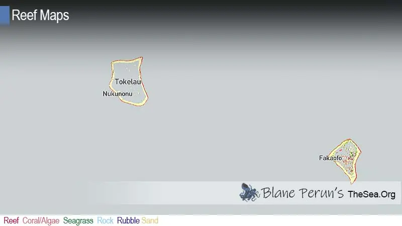
Atafu, Nukunonu and Fakaofo
Three atolls, three villages, each with its own lagoon and reef.
- Atafu (north-west) — the smallest of the three atolls, with a compact lagoon and a single village at its north-western corner.
- Nukunonu (centre) — the largest atoll, with the biggest lagoon and the most land, much of it in long motu around the rim.
- Fakaofo (south-east) — a ring of motu around a lagoon, with villages on the islets of Fale and Fenua Fala.
A fourth atoll in the same chain, Swains Island (Olohega), is culturally linked to Tokelau but is administered by the United States as part of American Samoa. Geologically, all of these atolls are the tops of ancient volcanoes capped by thick coral limestone. See how coral atolls form.
How an atoll reef works
Outer reef, reef flat, motu and lagoon each play a different role.
The outer reef faces the open ocean. Its crest, cemented by crustose coralline algae, takes the full force of the swell and breaks waves before they reach land; beyond it the reef slope drops steeply into deep water. Behind the crest lies the reef flat, a broad shallow platform where islanders glean shellfish and fish at low tide. On top of the reef flat sit the motu, piles of coral sand and rubble thrown up by waves and storms. Inside is the lagoon, sheltered water with patch reefs, sand and seagrass, connected to the ocean through shallow channels across the rim.
Each part depends on the reef staying alive. Corals, coralline algae, shells and foraminifera produce the sediment that builds and repairs the motu, and the reef crest protects them from waves. If the reef stops growing, the islands slowly lose their sand supply. See what is an atoll reef.
Reef life and fishing in Tokelau
Lagoon and reef fish are central to the Tokelauan diet and to village life.
Tokelau’s reefs hold a typical central Pacific atoll community: branching and table corals on the outer slopes, patch reefs in the lagoons, and fish such as surgeonfish, parrotfish, groupers, snappers, goatfish and trevally. Giant clams, octopus and crabs are harvested on the reef flats, and tuna and other ocean fish are caught beyond the reef. Turtles visit the atolls, and reef sharks patrol the outer slopes.
Fishing is organised around village life. Under the custom of inati, catches from communal fishing are shared among households, and village councils of elders, the taupulega, can restrict fishing in certain areas or for certain species to keep stocks healthy. For more on reef communities, see what animals and plants live in coral reefs.
Living on the reef: remoteness and resilience
No airport, a ship from Samoa, and a community that depends on its lagoons.
Tokelau can only be reached by ship from Apia in Samoa, a voyage of more than a day, and there are no harbours: passengers and cargo are ferried across the reef in small boats. That isolation has helped keep Tokelau’s reefs relatively lightly exploited compared with crowded atolls elsewhere, but it also means the community relies heavily on local resources. Coconuts, breadfruit, pandanus and swamp taro grow on the motu; the lagoon and reef provide most of the protein. Fishing licence revenue from tuna fleets operating in Tokelau’s wider waters is an important source of income.
Visiting Tokelau’s reefs
Possible, but only with planning, permission and patience.
Visitors need a permit arranged through the Tokelau office in Apia before travelling, and the ship schedule means a stay is typically measured in days or weeks rather than hours. There are no dive shops or tour operators; snorkelling in the lagoons is the usual way to see the reef, and any trip to the outer reef or across the lagoon should be arranged with villagers who know the tides, currents and channels. Village rules apply to everything from where you may fish to how you dress and when you may swim, and closed areas set by the elders must be respected.
- Lagoon snorkelling — calm water over patch reefs, best on a rising tide when clear ocean water flows in.
- Reef flats — walk only with local guidance; the outer edge is dangerous in swell.
- Respect closures — areas rested by the taupulega are off-limits for fishing and gathering.
- Take rubbish home — waste disposal is hard on small atolls, so pack out what you bring.
Threats to Tokelau’s coral reefs
Rising seas, storms and warming water.
Sea-level rise is the defining threat. With land only a few metres above high tide, the motu are exposed to erosion, flooding during king tides and storms, and saltwater intrusion into wells and taro pits. Cyclones can overwash entire islets; Cyclone Percy in 2005 caused serious flooding and damage. Marine heatwaves bleach corals and can slow the reef growth the islands depend on. Locally, waste disposal and fishing pressure near villages add strain to a small system. Keeping the reefs healthy is one of the few natural defences Tokelau has. See our reef conservation pages and coral reef bleaching.
Related on TheSea
How many atolls are in Tokelau?
Three: Atafu, Nukunonu and Fakaofo. Each is a ring of coral reef around a lagoon. UNEP-WCMC maps roughly 97 km² of reef across them.
Where is Tokelau?
Tokelau lies in the central Pacific north of Samoa. It is a territory of New Zealand and can only be reached by ship from Apia.
Which is the largest atoll in Tokelau?
Nukunonu is the largest, with the biggest lagoon and the most land. Atafu is the smallest.
Is Swains Island part of Tokelau?
Swains Island (Olohega) is geographically and culturally linked to Tokelau, but it is administered by the United States as part of American Samoa.
Is Tokelau threatened by sea-level rise?
Yes. Its land is only a few metres above high tide, so rising seas increase erosion, flooding and saltwater intrusion. Healthy reefs that keep producing sand help the islets persist.
What do people in Tokelau eat from the reef?
Lagoon and reef fish, octopus, giant clams and crabs, plus tuna caught offshore. Catches are traditionally shared among households through the custom of inati.
- UNEP-WCMC, WorldFish Centre, WRI, TNC: Global distribution of warm-water coral reefs, v4.1 (2021)
- Government of Tokelau: Tokelau Renewable Energy Project (2012)
- Pacific Community (SPC): Tokelau coastal fisheries profile
Blane Perun has been exploring Earth’s oceans and marine life for over 25 years. Founder of TheSea.Org in 1999, underwater photographer, coral aquaculture pioneer, and explorer of 80+ countries.
About Blane Perun → More Oceania Coral Reef Maps →