Guam Coral Reef Maps — Fringing Reefs, Lagoons and Marine Preserves
Coral reefs ring almost the entire coast of Guam, the largest and southernmost island of the Mariana chain. Most are fringing reefs with broad, shallow reef flats; in the south they widen into the barrier reef and Cocos Lagoon off Merizo. Key reef areas include Tumon Bay and Piti on the west coast, the reef-sheltered Apra Harbor with its famous wrecks, Achang Reef Flat in the south, and the rugged reefs below the northern limestone cliffs at Pati Point. UNEP-WCMC maps roughly 137 km² of reef, and five marine preserves protect key areas.
Guam is a busy island — home to well over a hundred thousand people, a major tourism industry and large US military bases — and its reefs feel that pressure more than most in Micronesia. Yet the island is still ringed by reef, from the calm lagoon of Tumon Bay to the wild, wave-battered north. This page maps Guam’s reefs, explains why north and south are so different, and looks at how the island is trying to protect them.
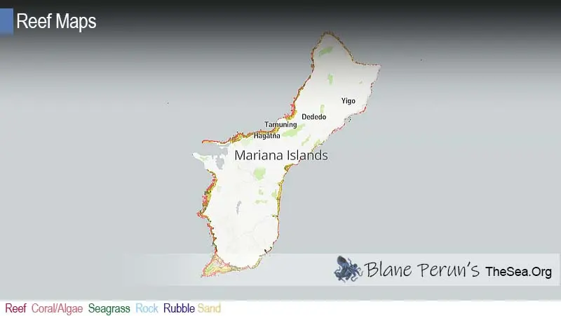
Guam coral reef map
A near-continuous fringe of reef, widening into a lagoon in the south.
On the map, coral shading follows almost the whole coastline. Along the west coast, reef flats front Tumon Bay, Hagåtña and Piti, then wrap around Orote Peninsula to enclose Apra Harbor. In the far south, the reef broadens into a barrier reef around Cocos Lagoon and Cocos Island. The east coast reefs face the trade-wind swell and are narrower and more exposed.
The reef outlines come from the UNEP-WCMC global warm-water coral reef dataset, combining satellite imagery and field surveys. Shading shows mapped reef extent, not live coral cover. Reefs of the Northern Mariana Islands, a separate US territory, are not included here.
Two islands in one: limestone north, volcanic south
Geology explains why Guam’s northern and southern reefs are so different.
Northern Guam is a raised limestone plateau ringed by cliffs, made of ancient reef. Rain soaks straight into the rock, there are no rivers, and the water offshore tends to be very clear. Reefs here are narrow fringes at the foot of the cliffs, exposed to swell. Southern Guam is older volcanic rock with red clay soils, steep hills and rivers such as the Talofofo and Ugum. After heavy rain, those rivers carry sediment onto nearshore reefs, and some southern bays are naturally murkier. Wildfires on southern grasslands make erosion worse.
The contrast matters for management: reefs in the south are especially sensitive to land clearing and fires upstream, while those in the north are more affected by groundwater quality and coastal development. For background, see how coral reefs are formed.
Tumon Bay, Apra Harbor and Guam’s main reef areas
From hotel-lined lagoons to wrecks and blue water.
- Tumon Bay (north-west) — a shallow reef-flat lagoon in front of Guam’s hotel district, protected as a marine preserve; popular with snorkellers.
- Piti Bomb Holes (west) — deep sand holes in the reef flat, part of a marine preserve, with an underwater observatory nearby.
- Apra Harbor (west) — a reef-sheltered harbour, now a major port and naval base, with the WWI German cruiser SMS Cormoran and the WWII Japanese freighter Tokai Maru lying side by side on the seabed.
- Orote Peninsula dive sites — walls, caverns and the “Blue Hole”, a vertical shaft in the reef that opens onto a deep wall.
- Cocos Lagoon (south) — a barrier-reef lagoon with Cocos Island, seagrass, patch reefs and resident spinner dolphins offshore.
- Achang Reef Flat and Pati Point — preserves in the south and far north-east, protecting reef flat and exposed cliff-foot reef.
More wreck sites are described in our shipwrecks section.
Reef life around Guam
A western Pacific fauna close to the Coral Triangle, but stressed in places.
Guam’s reefs host a rich Indo-Pacific community, with hundreds of species of hard coral and reef fish. Shallow reef flats once held large stands of staghorn Acropora, while slopes have massive Porites, plate corals and soft corals. Reef fish include parrotfish, surgeonfish, rabbitfish, groupers, Napoleon wrasse and schooling jacks; green and hawksbill turtles are common, and spinner dolphins gather off the south-west coast. Just offshore, the seafloor drops toward the Mariana Trench, the deepest place in the ocean. For background, see what animals and plants live in coral reefs.
Marine preserves and reef management
Five no-take preserves, plus federal and community programmes.
In 1997 Guam designated five marine preserves — Tumon Bay, Piti Bomb Holes, Sasa Bay, Achang Reef Flat and Pati Point — where most fishing is banned, with limited exceptions for traditional practices. Studies have shown fish numbers and sizes increasing inside the preserves compared with fished areas. Coastal waters off Asan and Agat are also part of the War in the Pacific National Historical Park. As a US territory, Guam takes part in federal coral reef programmes and long-term monitoring, and local agencies and volunteers run reef restoration projects, including coral nurseries for staghorn coral.
Diving and snorkelling in Guam
Easy shore snorkelling on the west coast, and serious diving off Orote and in Apra Harbor.
Guam is one of the most accessible reef destinations in Micronesia, with regular flights and many dive operators. Snorkellers can walk straight into the shallow lagoons of Tumon Bay and the Piti preserve, where fish are used to people and the water is calm on most days. Divers head for Apra Harbor’s wrecks, the Blue Hole and nearby walls off Orote Peninsula, and boat sites in the south near Cocos Island. The east coast is usually too rough for casual entry.
- Mind the reef flat edge — currents and surge can be strong where reef flats meet open water, and channels can pull seaward on a falling tide.
- Respect the preserves — fishing and collecting are banned in Guam’s five marine preserves.
- Avoid standing on coral — shallow reef flats are easily damaged, especially the recovering staghorn areas.
- Check conditions after rain — visibility near southern river mouths can drop sharply after storms.
Threats to Guam’s coral reefs
Heat, sediment and the pressures of a busy island.
Marine heatwaves are the biggest threat: several years of back-to-back bleaching during the mid-2010s killed a large share of shallow corals in places, including much of the staghorn on some reef flats. Sediment runoff from southern watersheds smothers coral after storms. Coastal development, wastewater and military construction affect water quality, especially on the west coast. Overfishing has reduced large fish outside the preserves, and crown-of-thorns starfish outbreaks have damaged reefs. Typhoons periodically break up shallow coral. See our reef conservation and coral reef bleaching pages.
Related on TheSea
Does Guam have coral reefs?
Yes. Fringing reefs ring almost the whole island, widening into a barrier reef and Cocos Lagoon in the south. UNEP-WCMC maps roughly 137 km² of reef.
Where is the best snorkelling in Guam?
Tumon Bay and the Piti Bomb Holes marine preserves are the most popular, with easy shore access and protected fish life. Cocos Lagoon in the south is another good option by boat.
What are Guam’s marine preserves?
Five preserves designated in 1997: Tumon Bay, Piti Bomb Holes, Sasa Bay, Achang Reef Flat and Pati Point. Most fishing is prohibited inside them.
Can you dive two wrecks at once in Guam?
Yes. In Apra Harbor, the WWI German cruiser SMS Cormoran and the WWII Japanese freighter Tokai Maru lie touching each other, so divers can see wrecks from both world wars on one dive.
Are Guam’s reefs healthy?
They are under pressure. Repeated bleaching in the mid-2010s killed many shallow corals, and runoff and development affect nearshore reefs, but preserves and restoration projects are helping in places.
Are Guam’s reefs the same as the Northern Mariana Islands’?
They share the same island arc, but Guam is a separate US territory from the Commonwealth of the Northern Mariana Islands, and their reefs are mapped and managed separately.
- UNEP-WCMC, WorldFish Centre, WRI, TNC: Global distribution of warm-water coral reefs, v4.1 (2021)
- Guam Department of Agriculture, Division of Aquatic and Wildlife Resources: marine preserves
- NOAA Coral Reef Conservation Program: Guam reef monitoring
Blane Perun has been exploring Earth’s oceans and marine life for over 25 years. Founder of TheSea.Org in 1999, underwater photographer, coral aquaculture pioneer, and explorer of 80+ countries.
About Blane Perun → More Oceania Coral Reef Maps →