Bering Sea — The Cold, Crab-Rich Sea Between Alaska and Russia
The Bering Sea is the northernmost arm of the Pacific Ocean, covering about 2.0–2.3 million km² between Alaska and the Russian Far East. It is bounded to the south by the arc of the Aleutian Islands and to the north by the Bering Strait, which links it to the Arctic Ocean. Its eastern half is a vast, shallow continental shelf mostly less than about 150 m deep; its south-western half is a deep basin reaching about 4,097 m. Seasonal sea ice and nutrient-rich water make it one of the most productive seas on Earth — it supplies a large share of the United States’ fish and shellfish catch, from pollock and salmon to king and snow crab.
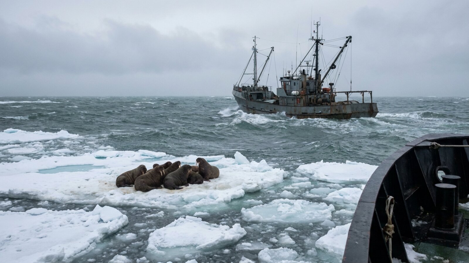
The Bering Sea is a place of extremes: winter ice that advances hundreds of kilometres in a few months, storms that build some of the roughest seas fished anywhere, and summer blooms that feed millions of seabirds, walruses, seals and whales. It is also one of the great food baskets of the world, and one of the clearest places on the planet to watch climate change unfold, as warming water and vanishing ice reshape everything from plankton to crab. Below we explain where the Bering Sea is, why it is really two seas in one, how sea ice and the “cold pool” work, why it is so productive, what lives there, its history of exploration and fur-seal wars, its fisheries, and how it is changing.
Where is the Bering Sea, and where are its boundaries?
The Bering Sea is a marginal sea of the North Pacific, and together with the Bering Strait it forms the divide between the two largest landmasses on Earth, Eurasia and the Americas. It is bordered on the east and north-east by mainland Alaska, on the west by the Russian Far East and the Kamchatka Peninsula, and on the south by the Alaska Peninsula and the chain of the Aleutian and Komandorski (Commander) islands. The Alaska Peninsula separates it from the Gulf of Alaska. In the far north the Bering Strait, about 85 km (53 mi) wide at its narrowest and only 30–50 m deep on average, connects it to the Chukchi Sea and the Arctic Ocean.
The International Hydrographic Organization draws the southern limit as a line from Kabuch Point on the Alaska Peninsula through the Aleutians to the southern tips of the Komandorski Islands and on to Cape Kamchatka, so that all the narrow passes between the islands belong to the Bering Sea. The northern limit is the southern edge of the Chukchi Sea, roughly the Arctic Circle between Siberia and Alaska. Within those lines Britannica gives an area of about 2,304,000 km² (890,000 sq mi) including islands, a maximum east–west width of about 1,490 miles and a north–south length of about 990 miles; other references round the area down to “over 2,000,000 km²”. The difference is a matter of where the gulfs and island waters are counted, not of measurement error.
The sea has several large named bays and sounds. Bristol Bay, the shallow south-eastern corner between the Alaska Peninsula and Cape Newenham, is about 400 km long and 290 km wide at its mouth. Norton Sound cuts into the Alaskan coast south of the Seward Peninsula, and the Gulf of Anadyr indents the Chukotka coast on the Russian side. Its islands include the Pribilofs (St. Paul and St. George), St. Lawrence, St. Matthew, Nunivak, King, the two Diomedes in the strait, Karaginsky off Kamchatka and the Commander Islands, the largest of which is Bering Island.
How deep is the Bering Sea? Two seas in one
The Bering Sea is really two very different bodies of water joined along a single, sharp edge. The north-eastern half lies over the North American Plate as one of the widest continental shelves in the world, a flat plain mostly less than 150 m (500 ft) deep that runs for hundreds of kilometres from Alaska towards Siberia. The south-western half is the deep Aleutian Basin, an oceanic plate that is the remnant of the ancient Kula Plate, most of which was long ago subducted beneath Alaska. Britannica places the floors of its Aleutian, Bowers and Komandor basins at about 12,000–13,000 ft (roughly 3,700–4,000 m), with the deepest sounding, 4,097 m (13,442 ft), in the Bowers Basin.
The deep basin is itself split by two submarine ridges. The Shirshov Ridge runs about 750 km south from Russia’s Olyutorsky Peninsula, and the Bowers Ridge, a former volcanic island arc, curves for about 900 km out from the Aleutians to meet it. Together they divide the deep water into the Commander Basin in the west and the Bowers Basin, enclosed by the Bowers Ridge and the Aleutians, in the south. The Earth’s crust reflects the split: Britannica gives a thickness of more than 12 miles under the shelves and the Aleutians but only about 6–9 miles under the deep sea.
Between shelf and basin, the shelf break and slope are cut by a series of large submarine canyons. The Pribilof, Pervenets, Bering and Zhemchug canyons are among the biggest, and Zhemchug is the largest submarine canyon known by volume. These canyons matter far beyond geology. They channel deep, nutrient-rich water up onto the shelf edge and concentrate krill, squid and fish, which is why they are hot spots for seabirds and whales.
Why does the Bering Sea freeze, and what is the “cold pool”?
Sea ice forms in the north each autumn and is blown south across the shelf by cold northerly winds, melting at its leading edge where it meets warmer water. The northern part of the sea is ice-covered every winter, and the ice is usually more severe on the western, Russian side than along the Alaskan coast. Britannica gives mean annual air temperatures from about −10 °C in the north to about 4 °C in the south, winter lows of −35 to −45 °C in the north and east, and surface water from about 1 °C in the north to 5 °C in the south. January and February are the coldest months and July and August the warmest.
When that ice melts in spring it leaves behind a layer of very cold bottom water over the middle of the shelf. Scientists call this the cold pool: the part of the eastern shelf where bottom water stays below 2 °C through the summer. It acts as an invisible fence. Arctic species such as snow crab and Arctic cod are comfortable inside it, while sub-Arctic fish such as walleye pollock and Pacific cod tend to stay around its edges. Its size and position from year to year help decide where fish are found, how much energy cold-water animals need and where fishing fleets can work.
Surface salinity is relatively low, about 31–33 parts per thousand, because of melting ice and the outflow of large rivers, chiefly the Yukon and Kuskokwim on the Alaskan side and the Anadyr on the Russian side; in the deep basins it rises to about 35. The overall flow of water is northward along the Alaskan side and southward along Asia in the Kamchatka Current, and the whole system ends in the Bering Strait, where Pacific water spills into the Arctic. Mooring records showed that flow rising by about half, from roughly 0.7 to 1.1 sverdrups between 2001 and 2011, carrying more heat and fresh water into the Arctic Ocean.
Why is the Bering Sea so productive?
Two engines drive the Bering Sea’s exceptional productivity. The first is the shelf break, sometimes called the “Green Belt”. Along the edge where the shelf drops into the basin, cold, nutrient-rich water from the Aleutian Basin flows up the slope and mixes with shelf water, feeding phytoplankton almost continuously through the growing season. The Green Belt and its canyons are where much of the sea’s pollock, squid, fur seals and seabirds feed.
The second engine is the ice. Melting sea ice spreads a lid of lower-salinity water over the middle and outer shelf in spring, which stabilises the surface layer and holds phytoplankton in the light. The ice itself carries algae growing on and inside it, and these are released as it melts. The result is an intense spring bloom. Over the shallow shelf, much of that bloom is not eaten in the water column but sinks to the seafloor, where it feeds an extraordinarily rich bottom community of clams, amphipods, polychaete worms, brittle stars and crabs. This tight link between the surface and the seabed is what supports the walrus, bearded seals, gray whales and diving sea ducks that feed on the bottom.
That system is not fixed. Carbon isotopes in historical samples of bowhead whale baleen, which record what the whales were eating, suggest that average seasonal primary productivity fell by about 30–40% over the last half century. In the northern Bering Sea, Grebmeier and colleagues reported in Science in 2006 that the system was already shifting away from heavy ice cover and tight bottom coupling, with fewer bottom prey, more pelagic fish, warmer air and water and marine mammals moving their feeding grounds.
What lives in the Bering Sea?
At least 419 species of fish have been recorded in the Bering Sea. Commercially, the most important are walleye (Alaska) pollock, Pacific cod, several flatfish, sablefish, Pacific herring and Pacific salmon, together with red king crab, snow crab and Tanner crab. Bristol Bay supports the largest sockeye salmon run in the world, and all five species of eastern Pacific salmon spawn in the rivers that feed it.
The sea is equally important for marine mammals. Whales include beluga, bowhead, gray, humpback, fin, sei, sperm, blue and orca, as well as the eastern North Pacific right whale, often described as the rarest large whale in the world. Pacific walrus haul out on the ice and on remote beaches, Steller sea lions breed on rocky islands and in the north the ice supports ringed, bearded, spotted and ribbon seals and polar bears. The Pribilof Islands are the main breeding ground of the northern fur seal: of an estimated 1.1 million across the species’ range, roughly half breed there, with another 200,000–250,000 on the Commander Islands.
More than 30 species of seabirds, totalling around 20 million individuals, breed in the Bering Sea region. They include murres, tufted and horned puffins, crested and least auklets, red-legged kittiwakes, and the endangered short-tailed albatross, which forages along the shelf edge. Crested auklet colonies can number more than a million birds. The Pribilof, Zhemchug and Pervenets canyons are among the richest foraging areas, because the upwelling there concentrates their prey.
The Bering Sea also has a sad record of extinctions caused by people. Steller’s sea cow, a giant relative of the manatee, survived only around the Commander Islands when Bering’s crew found it in 1741, and was hunted out within about three decades. The spectacled cormorant, the largest cormorant known, which lived on Bering Island and which Georg Steller described as so heavy that one bird could feed three starving men, disappeared around 1850. A small subspecies, the Bering Canada goose, was also lost to overhunting and to rats introduced to its breeding islands.
How was the Bering Sea explored and named?
People reached the region long before Europeans. During the ice ages, so much water was locked in ice sheets that the shallow Bering shelf was exposed as dry land. The Bering land bridge, part of the wider region called Beringia, was up to about 1,000 km wide at its greatest extent. Sea-level reconstructions suggest a land connection from roughly 30,000 to 11,000 years ago, after which the rising sea reopened the strait. Most researchers think the first people to reach the Americas crossed or skirted this land, and animals moved in both directions. The islands of the Pribilofs, St. Lawrence, St. Matthew, King Island and the Diomedes are the high points of that drowned plain.
The sea is named after Vitus Bering, a Danish navigator in Russian service. On the First Kamchatka Expedition he sailed the St. Gabriel north from Kamchatka in July 1728, sighted St. Lawrence Island and passed through the strait, deciding that there was open sea between Asia and America, although he did not see the American shore. On the far larger Great Northern Expedition he reached southern Alaska in 1741, but on the way back his ship was wrecked on an uninhabited island in the Commanders. Bering died there on 19 December 1741, reportedly of scurvy, along with 28 of his men, and the island now bears his name. The survivors, among them the naturalist Steller, built a boat from the wreck and returned to Kamchatka the following year with sea otter pelts that launched the Russian fur trade in Alaska.
The fur seal wars and the Bering Sea arbitration
The fur trade shaped the politics of the sea. In 1786 the Russian navigator Gavriil Pribylov found the islands that now carry his name, with rookeries that held upwards of four million fur seals. An estimated 2.5 million seals were killed between 1786 and 1867. After the United States bought Alaska in 1867, it leased the Pribilof harvest to the Alaska Commercial Company, while Canadian schooners began shooting seals at sea, a practice called pelagic sealing that killed mostly nursing females and left their pups to starve.
The United States seized Canadian sealing vessels and claimed control of the whole eastern Bering Sea. Britain, then responsible for Canada’s foreign affairs, disputed the claim, and the two countries took the case to an international tribunal in Paris. Its award of 15 August 1893 went in favour of Britain on every point: the Bering Sea was not an American closed sea. The tribunal did set a 60-mile protected zone around the Pribilofs and a closed season, but the rules failed, because nursing females fed far outside the zone, and the 1894 pelagic catch was the largest ever. The Pribilof herd fell to about 216,000 animals by 1912. Only the North Pacific Fur Seal Convention of 1911 between Britain, Japan, Russia and the United States ended open-ocean sealing, one of the first international wildlife treaties.
Modern boundaries still trace that history. The 1867 purchase line from the middle of the Bering Strait towards the gap between the Aleutian and Commander islands was the basis for the 1990 USSR–USA Maritime Boundary Agreement, known as the Baker–Shevardnadze line. The US Senate approved it in 1991; Russia’s parliament has never ratified it, though both countries have respected the line. Beyond the two 200-mile zones lies a patch of international water in the central basin, the “Donut Hole”. Fleets from several nations fished pollock there heavily in the late 1980s until the basin stock collapsed, and in 1994 China, Japan, South Korea, Poland, Russia and the United States signed a convention on the conservation of pollock in the central Bering Sea.
Fisheries: pollock, salmon and crab
The eastern Bering Sea is the engine of American fishing. NOAA reported in 2019 that it yields more than 40% of the annual US fish and shellfish catch. The largest single fishery is walleye pollock, the biggest landing of any fish species in the United States: the eastern Bering Sea catch averaged about 1.26 million tonnes a year between 1979 and 2022, and about 92% of the US pollock catch comes from the Bering Sea. Most of it becomes fillets, fish sticks and surimi. The Russian side of the sea supports large pollock, cod and crab fisheries of its own.
Crab fishing made the Bering Sea famous through the television series Deadliest Catch. Red king crab are fished mainly in Bristol Bay, while snow crab (Chionoecetes opilio) range across the colder middle and northern shelf. The work is dangerous because it is done in late autumn and winter, among storms, freezing spray that can capsize a boat with the weight of ice, and water cold enough to kill within minutes. Seasons and catch limits are now set each year by the Alaska Department of Fish and Game from NOAA’s trawl surveys.
What happened to the Bering Sea snow crab?
The collapse of the eastern Bering Sea snow crab is one of the starkest examples of a marine heatwave’s effect on a fishery. Szuwalski and colleagues, writing in Science in 2023, found that more than 10 billion snow crab disappeared from the eastern Bering Sea after 2018, and that the population had collapsed to historical lows by 2021. They linked the loss to the 2018–2019 marine heatwave: warmer water raised the crabs’ caloric needs, the area of suitable cold habitat shrank, and the animals’ body condition pointed to starvation. It was among the largest losses of mobile marine animals reported from any heatwave anywhere.
The snow crab season was closed for the first time for 2022–23 and stayed closed for 2023–24. It reopened for 2024–25 with a total allowable catch of 4.72 million pounds (about 2,140 tonnes), a fraction of the harvests of the 2010s. The limit was raised to 9.3 million pounds for 2025–26, and in October 2026 the state set a 2026–27 limit of 5.1 million pounds, alongside 3.41 million pounds of Bristol Bay red king crab. The recovery is real but slow, and its pace depends on whether cold years return.
How is climate change affecting the Bering Sea?
The winter of 2017–18 brought the lowest winter-maximum sea-ice cover in the Bering Sea since records began in 1980. Stabeno and Bell showed that warm southerly winds delayed the ice in November and drove it back in February and March, and that the cold pool shrank to its smallest on record, both because there was no melting ice to chill the bottom water and because weaker layering let summer heat reach the seafloor. February 2019 brought another outbreak of warm southerly winds and another very low-ice year. The rapid change contrasts with the period from 1979 to 2012, when Bering Sea ice extent grew slightly even as summer ice in the Arctic Ocean to the north shrank.
The ecological effects followed quickly. With the cold pool gone, pollock and Pacific cod spread north onto the northern shelf, and NOAA’s 2019 report linked the change to shifts in their distribution. Juvenile sockeye salmon in the south-eastern Bering Sea became more abundant and moved their migration path north as the water warmed. Seabirds suffered repeated die-offs: in October 2016 to January 2017 an unusual mortality of alcids, mostly tufted puffins, hit St. Paul Island, with an estimated 3,150 to 8,800 birds killed. Harmful algal blooms of the toxic dinoflagellate Alexandrium catenella are increasing in the Bering and Chukchi seas as they warm, raising the risk of shellfish poisoning in coastal villages.
These changes matter most to the roughly 70 Indigenous communities of the Bering Sea region, many of which depend on walrus, seals, fish and seabirds for food. Thinner, later and less reliable ice makes hunting more dangerous and leaves coasts exposed to autumn storms that the ice once buffered. The Bering Sea remains highly productive, but its future depends on how often it still has the cold winters that built its ecosystem.
Where is the Bering Sea?
It is the northern arm of the Pacific between Alaska and the Russian Far East, bounded by the Alaska Peninsula and the Aleutian and Commander islands to the south and the Bering Strait to the north.
How deep is the Bering Sea?
The north-eastern shelf is mostly under 150 m, but the south-western basins are about 3,700–4,000 m deep, with a maximum of 4,097 m in the Bowers Basin.
How big is the Bering Sea?
About 2.0–2.3 million km² (770,000–890,000 sq mi), depending on the boundaries used; Britannica gives 2,304,000 km² including islands.
Does the Bering Sea freeze?
The northern part is ice-covered every winter, and ice usually spreads south across the eastern shelf, but the winter of 2017–18 brought the lowest ice cover on record and 2019 was another very low-ice year.
Why is the Bering Sea famous for crab fishing?
Its cold, shallow, productive shelf supports large populations of red king, snow and Tanner crab, and the dangerous winter fishery became famous through Deadliest Catch.
What happened to the Bering Sea snow crabs?
More than 10 billion vanished after 2018, linked to a marine heatwave and probable starvation. The fishery closed for two seasons and reopened in 2024–25 with a small quota.
Who is the Bering Sea named after?
Vitus Bering, a Danish navigator in Russian service who sailed through the strait in 1728 and died on Bering Island in 1741.
How wide is the Bering Strait?
About 85 km (53 mi) at its narrowest, and only 30–50 m deep.
- Encyclopædia Britannica. Bering Sea and Strait. Accessed November 2026.
- Wikipedia. Bering Sea; Aleutian Basin; Beringia; Vitus Bering; Bering Sea Arbitration; Northern fur seal; Pribilof Islands; Bristol Bay; Alaska pollock; USSR–USA Maritime Boundary Agreement. Accessed November 2026 via offline mirror.
- Szuwalski, C.S. et al. (2023). The collapse of eastern Bering Sea snow crab. Science. doi:10.1126/science.adf6035
- Stabeno, P.J. & Bell, S.W. (2019). Extreme conditions in the Bering Sea (2017–2018): record-breaking low sea-ice extent. Geophysical Research Letters. doi:10.1029/2019GL083816
- Woodgate, R.A. et al. (2012). Observed increases in Bering Strait oceanic fluxes from the Pacific to the Arctic from 2001 to 2011. Geophysical Research Letters. doi:10.1029/2012GL054092
- Grebmeier, J.M. et al. (2006). A major ecosystem shift in the northern Bering Sea. Science. doi:10.1126/science.1121365
- Jones, T. et al. (2019). Unusual mortality of tufted puffins in the eastern Bering Sea. PLoS ONE. doi:10.1371/journal.pone.0216532
- Yasumiishi, E.M. et al. (2024). Covariates of juvenile sockeye salmon distribution in the south-eastern Bering Sea, 2002–2018. Ecology and Evolution. doi:10.1002/ece3.11195
- Lange, P.K. et al. (2025). Satellite models for Alexandrium catenella bloom monitoring in the Bering and Chukchi seas. Journal of Environmental Management. doi:10.1016/j.jenvman.2025.125042
- Convention on the Conservation and Management of Pollock Resources in the Central Bering Sea (1994). International Legal Materials (1995). doi:10.1017/S0020782900015448
- Associated Press / NOAA Arctic Report Card (December 2019), via Al Jazeera: climate change hitting top US fishery.
- Baird Maritime (8 October 2026). Alaska sets 2026–27 Bering Sea crab catch limits (ADF&G figures).
Blane Perun has been exploring Earth’s oceans and marine life for over 25 years. Founder of TheSea.Org in 1999, underwater photographer, coral aquaculture pioneer, and explorer of 80+ countries.
About Blane Perun → More on Seas →