Niue Coral Reef Maps — The Rock of Polynesia and Its Crystal Reef
Niue’s coral reef is a narrow fringing reef that rings the entire island, sitting at the foot of limestone cliffs and dropping steeply into deep, exceptionally clear water. Niue is one of the largest raised coral islands in the world — an ancient atoll lifted above the sea, nicknamed “the Rock of Polynesia”. Because it has no rivers, almost no sediment reaches the reef. Niue’s waters also include Beveridge Reef, a remote, mostly submerged atoll far to the south-east. UNEP-WCMC maps roughly 15 km² of reef, and a large share of the national ocean is protected in the Moana Mahu marine protected area.
Niue is a single island with a small reef, yet divers rank it among the most memorable places in the Pacific. The reason is the combination of clear water, dramatic underwater topography and wildlife that comes right up to the shore: sea snakes in the shallows, spinner dolphins off the coast and humpback whales in the southern winter. This page maps Niue’s reef, explains how the island formed and looks at the threats it faces.
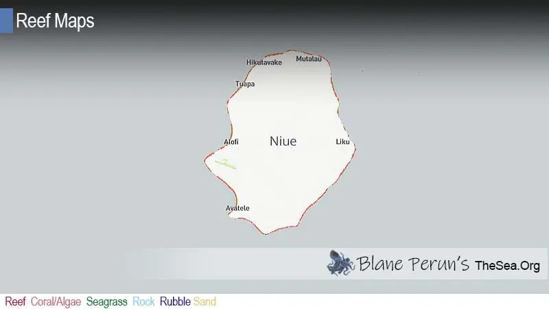
Niue coral reef map
One island, one thin ring of reef, deep water all around.
On the map, Niue appears as a single, roughly oval island with a narrow band of reef tracing its coastline. There is no lagoon and no barrier reef; the reef flat is often only tens of metres wide before it plunges into deep water. The west coast around the capital, Alofi, is the more sheltered side and has most of the access points, while the east coast takes the brunt of the trade-wind swell.
The reef outline comes from the UNEP-WCMC global warm-water coral reef dataset, combining satellite imagery and field surveys. It shows mapped reef extent, not live coral cover, and is not a navigation chart.
A raised coral island: the Rock of Polynesia
An old atoll pushed up out of the sea, now a limestone plateau ringed by cliffs.
Most Pacific reef islands are either high volcanic islands with fringing reefs or low atolls barely above the waves. Niue is a third type. It began as an atoll on top of a volcano, and was then lifted so that its old reef rim now forms a ring of higher ground, with a lower central plateau where the lagoon used to be. The coast is lined with cliffs and terraces of fossil reef, the highest parts rising to roughly 60 metres above the sea.
Rainwater has dissolved the limestone into caves, chasms and arches. Famous coastal sites such as the Matapa and Togo chasms, the Limu Pools and the Talava Arches show where the fossil reef meets the living one. Below the waterline, the same process has created sea caves and swim-throughs that make Niue’s diving unusual. See how coral reefs are formed and what is an atoll reef for background.
Why Niue’s water is so clear
No rivers, little soil runoff and deep ocean right offshore.
On most islands, rivers carry silt and nutrients onto the reef after rain. Niue has none: rainfall soaks straight down into porous limestone and emerges as freshwater seeps at the coast, already filtered. With a small population, little industry and deep oceanic water just beyond the reef, the sea around Niue is unusually transparent. Underwater visibility is regularly described as some of the best in the world, often many tens of metres. The trade-off is that the water is nutrient-poor, so coral cover is patchy and the reef is better known for its topography, clarity and big animals than for dense coral gardens.
Reef life: sea snakes, dolphins and whales
Small reef, big encounters.
Niue is famous for its sea kraits. The Niue sea krait or katuali, a banded sea snake found only around Niue, is common on the reef and in caves; like other sea kraits it is venomous but generally docile, and it should be watched rather than handled. Spinner dolphins are often seen off the west coast, and from roughly July to October humpback whales arrive from Antarctic waters to breed and calve, sometimes coming close enough to be seen from the cliffs or met by snorkellers. On the reef itself are surgeonfish, butterflyfish, parrotfish, triggerfish, moray eels, turtles and whitetip reef sharks, with hard corals growing on the walls and around cave entrances. Learn more in what animals and plants live in coral reefs.
Moana Mahu and Niuean life
A tiny nation with an outsized commitment to its ocean.
Niue is self-governing in free association with New Zealand and has a population of fewer than 2,000 people. Reef and nearshore fishing remain important for food, and the island’s small tourism industry is built around snorkelling, diving, whale-watching and the coastal chasms. In 2020 Niue created the Moana Mahu marine protected area, setting aside a large part of its exclusive economic zone, including Beveridge Reef, as a no-take zone. Village-based conservation and traditional fishing rules also help manage the reef close to shore.
Snorkelling and diving in Niue
Access is down steps and ladders through the cliffs, so conditions decide everything.
Because the coast is lined with cliffs, most reef access points are “sea tracks” — paths and steps cut down through the limestone to small coves and reef pools. On the sheltered west coast, sites around Alofi and the Limu Pools offer calm snorkelling on good days, and boat dives explore walls, caves and swim-throughs such as the cathedral-like caverns that Niue is known for. On the exposed east coast, swell often makes entry unsafe.
- Check the swell — even on sunny days waves can surge over the reef flat; never enter alone.
- Mind the reef edge — the drop-off is close to shore and currents can run along it.
- Go with local operators for diving and for swimming with whales, and follow Niue’s whale-watching guidelines.
- Leave the kraits alone — they are curious but should never be touched.
Threats to Niue’s reef
Storms and a warming ocean are the main dangers to a relatively healthy reef.
Niue’s reef is helped by clear water and light human pressure, but it is not immune. Cyclones are the most visible threat: Cyclone Heta in January 2004 drove huge waves over the cliffs, devastating parts of Alofi and smashing shallow reef. Marine heatwaves can bleach coral, and ocean acidification and long-term warming threaten reef growth everywhere. Local pressures such as fishing and coastal construction are modest but matter on a reef this small. See our reef conservation pages and coral reef bleaching.
Related on TheSea
Does Niue have a coral reef?
Yes. A narrow fringing reef rings the whole island, with steep walls and sea caves, and Niue’s waters also include Beveridge Reef, a submerged atoll. UNEP-WCMC maps roughly 15 km² of reef.
Why is Niue called the Rock of Polynesia?
Niue is one of the largest raised coral islands in the world: a single block of uplifted fossil reef limestone ringed by cliffs, rather than a volcanic island or a low atoll.
Why is the water in Niue so clear?
The island has no rivers. Rain soaks into the limestone instead of washing soil into the sea, and deep ocean lies just offshore, so the water around the reef is unusually clear.
When can you see whales in Niue?
Humpback whales visit from roughly July to October to breed and calve, often coming close to the coast.
Are the sea snakes in Niue dangerous?
Niue’s sea kraits are venomous but generally docile and rarely bite. Watch them calmly from a distance and never handle or corner them.
What is the Moana Mahu marine protected area?
Moana Mahu is a no-take marine protected area created by Niue in 2020, covering a large part of its exclusive economic zone, including Beveridge Reef.
- UNEP-WCMC, WorldFish Centre, WRI, TNC: Global distribution of warm-water coral reefs, v4.1 (2021)
- Government of Niue: Niue Moana Mahu Marine Protected Area Regulations 2020
- Pacific Community (SPC): Niue coastal fisheries and reef monitoring
Blane Perun has been exploring Earth’s oceans and marine life for over 25 years. Founder of TheSea.Org in 1999, underwater photographer, coral aquaculture pioneer, and explorer of 80+ countries.
About Blane Perun → More Oceania Coral Reef Maps →