Sunken City, San Pedro — Los Angeles’ Landslide Ruins by the Sea
Sunken City is the wreckage of part of the Point Fermin neighbourhood in San Pedro, Los Angeles, that began sliding toward the Pacific in a slow landslide in 1929. Streets, sidewalks and foundations broke apart and dropped down the cliff; most houses were moved, but two slid toward the sea. Unlike ancient sunken cities, it is not underwater — it is a jumbled coastal landslide next to Point Fermin Park. The site has been fenced off since the 1980s and is officially closed, though it remains famous for its graffiti-covered ruins and ocean views.
Who built the neighbourhood that slid?
In the 1920s the developer George H. Peck laid out cliff-top lots and bungalows at Point Fermin, the southern tip of San Pedro, for buyers who wanted to live with an unobstructed view of the Pacific. The site looked ideal. Point Fermin Park and its lighthouse, built in 1874 from California redwood, stood just to the west, the harbour of Los Angeles was growing to the north, and Paseo del Mar ran along the edge of the bluff with the ocean on one side and new homes on the other. A hotel, the Ocean View Inn, stood on the street, and the blocks south of Shepard Street between Carolina Street and Pacific Avenue filled with houses.
What nobody did was study the ground. Geologists who examined the site after the slide found almost no record of geotechnical investigation, and no soil or geological reports addressing whether the bluff was stable. That was not unusual in the 1920s, before building codes in California required such studies, but it meant that homes were built on top of a slope that had a built-in weakness.

What happened at Sunken City?

In 1929 a section of the Point Fermin coastline began moving seaward as a slow landslide, carrying streets and houses with it.
The Palos Verdes Peninsula is made of layered sedimentary rocks, including weak clays and volcanic ash beds, that tilt toward the ocean. Wave erosion at the base of the cliffs, water seeping into the ground from rain and irrigation, and the weight of development made the slope unstable. Movement was sometimes rapid enough to be measured in inches per day. Residents relocated most of the houses, but some were lost as the ground broke apart. Over the following decades the area kept moving and breaking up.
How did the slide unfold?
The first signs were plumbing problems. On 2 January 1929 a water line broke under the Ocean View Inn, and on 10 January a gas line broke under the same building. In early April, after heavy rain, a crack appeared on the surface. It ran in a rough semicircle from the east end of Point Fermin Park, across Paseo del Mar and through the block south of Shepard Street, then curved back to the bluff west of Pacific Avenue, enclosing about ten houses. In May the Los Angeles Times reported a hole ten feet long and three feet wide in front of one house. The local paper, the San Pedro News-Pilot, was more relaxed and expected that fixing a leaking pipe would solve the problem, but the city’s Board of Public Works advised residents to leave.
Engineers measured the ground moving at up to about 11 inches (28 cm) a day. Owners of 35 of the 39 affected lots signed a petition asking the city to buy their properties, and by December 1929 the crack was between 2 and 12 feet wide in places, although the city kept filling it to keep Carolina Street usable. Most of the houses on the 600 block of Paseo del Mar were jacked up and moved inland. Two could not be moved in time and slid toward the sea, and part of Point Fermin Park went with them.
The ground did not stop. In 1935 the slide was thought to have halted, but by April 1940 the bluff was moving about an inch a day, Paseo del Mar had been cut in two and seven families were stranded on the sinking block. Heavy rain in early 1941 widened the crack by another 8 feet in less than three weeks, while in the dry summer that followed it moved only 10 inches in two months. That pattern, fast in wet periods and slow in dry ones, is the signature of a slide driven by groundwater. By 1941 the ground had moved more than 30 feet seaward and 30 feet down. The city demolished damaged houses and bought most of the land for parkland. A later geological study put the total affected area at about 10.5 acres, and no one was killed while the slide was active.
Why is the Palos Verdes coast so unstable?
The Palos Verdes Peninsula is a block of uplifted sea-floor sediments, pushed up by faulting along the edge of the Los Angeles Basin. Its rocks include shales and layers of volcanic ash that have weathered into bentonite, a clay that swells when wet and becomes extremely slippery. On much of the peninsula these layers tilt gently toward the ocean. Where waves undercut the base of a cliff and water seeps down into a bentonite bed, the rock above can slide along the clay as a single block, a type of landslide geologists call a slump or block glide. At Point Fermin, rain, leaking water pipes and garden irrigation all added water to the ground, and the waves removed support at the toe of the slope.
Sunken City is only one of many slides on this coast. The best known is the Portuguese Bend landslide in Rancho Palos Verdes, a few miles west, part of an ancient slide complex that was reactivated in 1956 when road construction piled fill and water onto its upper slopes. Homeowners later won a lawsuit against Los Angeles County over that slide. Portuguese Bend has kept moving ever since, and after the very wet winters of 2023 and 2024 its movement sped up sharply, damaging hundreds of homes, forcing the closure and dismantling of the glass Wayfarers Chapel, and leading utilities to cut gas and power to many houses. Closer to Sunken City, a section of Paseo del Mar near the White Point Nature Preserve collapsed in 2011. These slides show that what happened at Point Fermin in 1929 was not a one-off, but part of an ongoing process along this coastline.
| Date | Event |
|---|---|
| 1920s | Point Fermin neighbourhood developed on the bluffs |
| 1929 | Landslide begins; houses relocated |
| 1930s–1941 | Continued sliding; Paseo del Mar severed; ground moves 30 ft seaward and 30 ft down |
| 1969 | Magnitude 5.0 earthquake opens new fissure nearby |
| 1987 | City fences off the area after injuries and complaints |
| 1989, 2015 | Proposals for regulated access, never carried out |
| 2026 | City Council funds monitoring, safety work and a new fence for partial access |
What happened to the site after the slide?
For decades the slide area was left alone, a jumble of tilted slabs, broken curbs, pipes and foundations known mostly to local residents. A magnitude 5.0 earthquake in 1969 opened a new fissure that damaged three homes along Paseo del Mar, a reminder that the ground around the site was not entirely settled. As Los Angeles grew, the ruins began to attract teenagers, partygoers and, later, graffiti artists. A chain-link fence did little to stop them. In 1982 a teenager fell from the cliffs while fleeing police who were clearing out trespassers, and in 1986 neighbours complained about after-hours parties, vandalism and theft. In 1987 the city replaced the chain-link with a wrought-iron fence costing more than $200,000.
The fence did not end the problem. The cliffs at and around Sunken City have been the scene of repeated deaths and injuries. Five people died in falls from cliffs in the area in 2003, four in 2006, and several more in 2007, including the USC football kicker Mario Danelo, who fell more than 100 feet. Trespassers can be fined up to $1,000, but people still climb the fence or walk around it along the bluff.
The site has also become part of Los Angeles popular culture. The Coen brothers filmed the scene in which Donny’s ashes are scattered in The Big Lebowski (1998) there, and it has appeared in the TV series Fear the Walking Dead, in songs and in novels. Its photogenic mix of graffiti, palm trees and ocean sunsets made it a fixture on social media, which brought still more visitors.
Is Sunken City an underwater city?
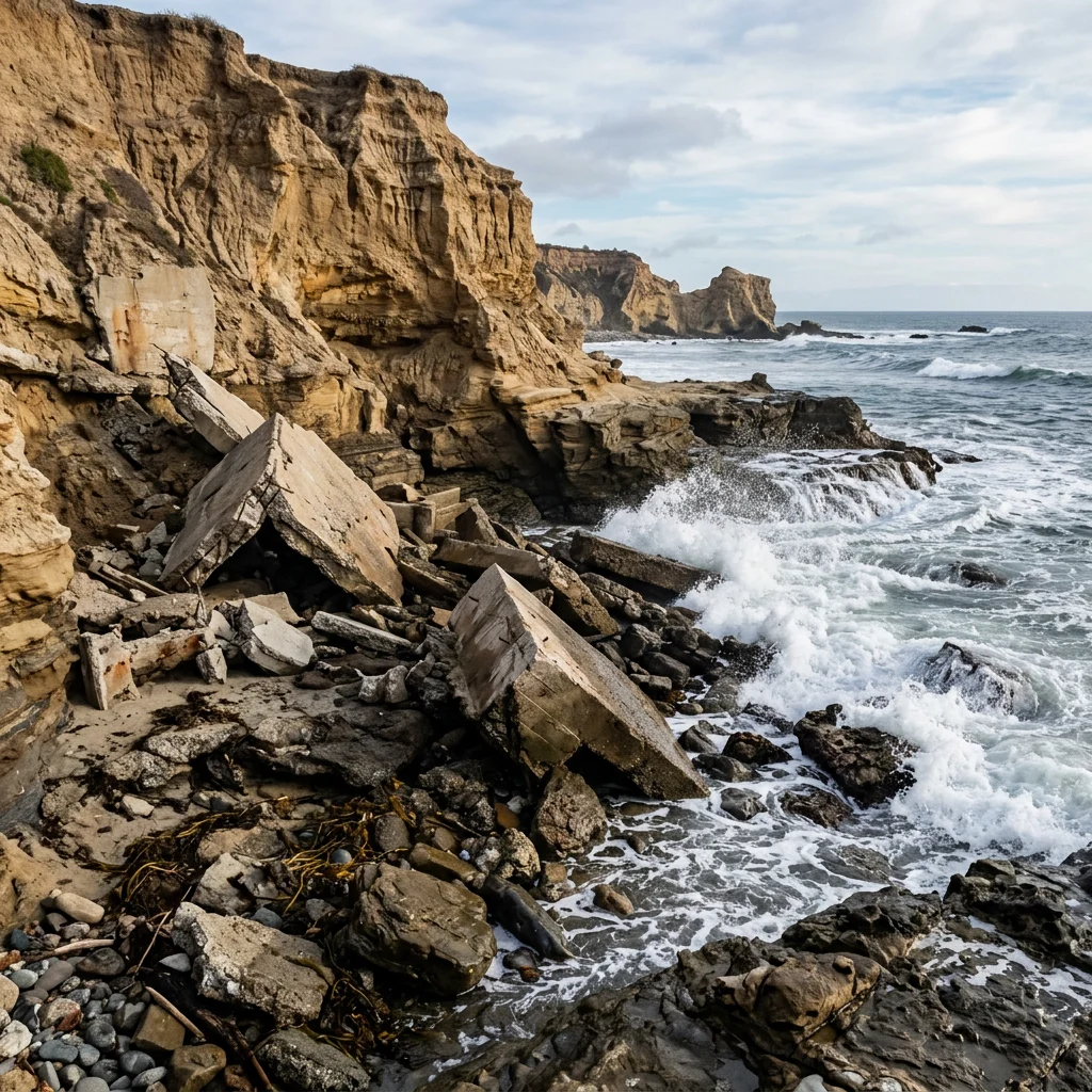
No. The name refers to land that “sank” down the cliff, not to ruins under the sea. Some broken concrete has reached the tide zone, but the site is a landslide. True underwater cities include Port Royal in Jamaica and Thonis-Heracleion in Egypt. The same coastline has a different underwater attraction: kelp forests and the rich marine life of the Palos Verdes Peninsula.
Can you visit Sunken City?

Officially, no. It is fenced and posted as closed by the City of Los Angeles because of crumbling cliffs, unstable slabs and falls; people have been seriously injured and trespassers can be fined. Proposals to open it with daytime access have been debated for decades, and in 2026 the city funded work toward opening the upper area. You can see much of the site from Point Fermin Park and the lighthouse, which is open to visitors.
Will Sunken City reopen?
The debate over access is nearly as old as the fence. In 1989 the then council member Joan Milke Flores proposed a nature trail with regulated access, but the gates were never installed. In 2015 the councilman Joe Buscaino proposed adding a gate that would open by day and close at sunset, with support from an online petition, but that plan also stalled. Supporters argue that the slide has been fairly stable for decades and that other stretches of coast are open; opponents point to the cliffs, the deaths and the city’s liability.
The latest plan is the most concrete so far. In 2026 the Los Angeles City Council approved funding for environmental monitoring and safety upgrades in the upper part of the site, including the design of a new fence, which needs coastal development permits. The office of council member Tim McOsker told LAist in June 2026 that the project was moving forward but could take about another year. If it goes ahead, visitors would be able to enter part of the upper landslide legally for the first time in decades, while the steepest, most dangerous areas near the cliff edge would stay closed.
Why is Sunken City covered in graffiti?
After it was fenced, the broken concrete slabs became an informal canvas for street artists, and the site developed a reputation as an urban-exploration spot. Graffiti, sunsets over the Pacific and the strange tilted landscape made it popular on social media, which in turn increased trespassing.
What else is there to see nearby?
Even without entering the fenced area, Point Fermin is worth a visit. The Point Fermin Lighthouse, a Victorian stick-style building designed by Paul Pelz, was first lit in 1874 and darkened in 1941 after the attack on Pearl Harbor. Saved from demolition and listed on the National Register of Historic Places in 1972, it is now a museum, and its original Fresnel lens, missing for decades, was found and returned to display in 2006. The Korean Bell of Friendship, given by South Korea to the United States in 1976, stands on a hill just to the north, and Cabrillo Beach and the Cabrillo Marine Aquarium are a short drive away.
The coast itself is rich in marine life. The rocky shore around Point Fermin and the Palos Verdes Peninsula has tide pools, and offshore lie kelp forests that shelter garibaldi, sheephead, sea lions and seals. From December to April the bluffs are good places to watch for gray whales migrating between Alaska and the lagoons of Baja California. Watching from the cliff-top paths, behind the fences, is the safest way to enjoy all of it. If you want to get closer to the water, the beaches and tide pools on either side of Point Fermin are reached by marked public paths; check tide tables first, because rising water can cut off rocky ledges below the bluffs.
Explore California’s marine life, such as California sea lions and the sea otters that live along nearby coasts.
What is Sunken City in San Pedro?
The remains of part of the Point Fermin neighbourhood destroyed by a landslide that began in 1929.
Is Sunken City San Pedro open to the public?
No. It is fenced and officially closed, and trespassers can be fined up to $1,000. In 2026 the city funded safety work that could allow partial access to the upper area.
Is Sunken City underwater?
No. It is a cliff-top landslide, not a submerged city.
What caused Sunken City?
A slow landslide on weak, seaward-tilting sedimentary rock, made worse by wave erosion and groundwater.
Where can you see Sunken City?
From Point Fermin Park and the Point Fermin Lighthouse in San Pedro.
- City of Los Angeles Department of Recreation and Parks. Point Fermin Park and Sunken City closure.
- Ehlig, P.L. (1992). Evolution, mechanics and mitigation of the Portuguese Bend landslide. In: Engineering Geology Practice in Southern California.
- Los Angeles Times archives (1929–1940). Point Fermin slide reports.
- Hernández, C. (28 June 2026) San Pedro’s Sunken City could reopen. LAist.
- San Pedro News-Pilot (1929–1941). Contemporary reports on the Point Fermin slide.
Blane Perun has been exploring Earth’s oceans and marine life for over 25 years. Founder of TheSea.Org in 1999, underwater photographer, coral aquaculture pioneer, and explorer of 80+ countries.
About Blane Perun →More on Sunken Cities →Did anyone die in the Sunken City landslide?
No one was killed by the slide itself, which moved slowly from 1929 into the 1940s, but many people have died or been injured falling from the cliffs since.
What movie was filmed at Sunken City?
The Big Lebowski (1998) filmed the scene where Donny’s ashes are scattered there.
