Dublin — A Viking Harbour on the Irish Sea
Dublin is the capital of Ireland, a city of about 590,000 (around 1.4 million in County Dublin) on the River Liffey where it meets Dublin Bay and the Irish Sea. Vikings founded a trading base here around 841. Top sights include Trinity College and the Book of Kells, Dublin Castle, Christ Church Cathedral and the Guinness Storehouse. Dublin Bay itself is a UNESCO Biosphere Reserve with grey seals, harbour porpoises and huge flocks of wintering birds.
Few capitals have this much wildlife at the end of a city bus line. Dublin Bay, a UNESCO Biosphere Reserve (North Bull Island since 1981, the whole bay since 2015), includes North Bull Island, a sand island that only formed after a harbour wall was built in the 1820s and now hosts tens of thousands of wintering waders and Brent geese. Grey and harbour seals haul out at Howth and Dalkey, harbour porpoises feed in the bay, and bottlenose dolphins are seen off the coast. The name itself is watery: Dubh Linn means “black pool”, after a tidal pool where the River Poddle met the Liffey.
Norse raiders established a longphort (ship base) on the Liffey around 841, and Viking Dublin became one of the biggest slave and trade markets in western Europe. After the Anglo-Norman invasion of 1169–1171, Dublin became the centre of English rule in Ireland for more than 700 years. The 1916 Easter Rising began here, and in 1922 Dublin became the capital of the Irish Free State, later the Republic of Ireland.
Dublin — at a glance
- Country: Republic of Ireland
- Population: ~590,000 city; ~1.46 million county (2022)
- River: Liffey, flowing into Dublin Bay
- Founded: Viking longphort c. 841
- Sea: Irish Sea
- UNESCO: Dublin Bay Biosphere Reserve, 2015
- Currency: Euro
People were fishing at the mouth of the Liffey long before there was a city. Excavations for the Convention Centre on the north quays uncovered wooden fish traps about 6,000 years old, and artefacts from Dalkey Island at the southern tip of the bay show that Mesolithic hunter-gatherers were using it even earlier. The Greco-Roman geographer Ptolemy, writing around AD 140, marked a place called Eblana on this coast, which may be the earliest written reference to a settlement near Dublin, although its exact location is uncertain. By the early medieval period there were two Irish settlements: a monastic site called Duibhlinn, beside the “black pool” where the River Poddle met the Liffey, and Áth Cliath, the “ford of hurdles”, a river crossing a little upstream near today’s Father Mathew Bridge. The modern Irish name for the city, Baile Átha Cliath, means “town of the hurdled ford”, while the English name comes from Duibhlinn.
In 841 a Norse fleet set up a fortified ship base on the river, and it grew into a busy trading town under kings such as Olaf Guthfrithson in the 10th century. Dublin officially celebrated its millennium in 1988, taking 988 as a founding date, but archaeologists now regard the Viking base of about 841, and the monastery before it, as the true beginnings. Viking Dublin traded in silver, slaves, furs, wine and textiles across a network reaching from Scandinavia to Spain and the Islamic world, and it stayed largely under Norse control, despite repeated Irish attacks, until the Anglo-Norman invasion launched from Wales in 1169.
After 1171 Dublin became the centre of English power in Ireland, protected by Dublin Castle, begun in 1204. Life in the medieval town was precarious. The Black Death reached Dublin in 1348 and killed thousands over the following decade, and a later plague in 1649–1651 wiped out almost half of a population that had been about 21,000 in 1640. The city’s great expansion came in the 18th century. Georgian Dublin briefly became the second-largest city in the British Empire and one of the five largest in Europe, with more than 130,000 people. Henrietta Street, laid out in the 1720s, is its earliest Georgian street, and in 1757 the Wide Streets Commission began reshaping the medieval core into the broad streets, squares and quays that still define the centre, including Merrion Square and the river frontage of the Custom House.
The 19th and early 20th centuries were harder. The Act of Union of 1800 moved political power to London, and Dublin’s poorer districts became some of the most overcrowded slums in Europe. In 1916 the Easter Rising was centred on the General Post Office on O’Connell Street, and the Rising, the War of Independence and the Civil War that followed left much of the centre badly damaged. In 1922 Dublin became the capital of the Irish Free State. Its literary reputation, from Swift and Wilde to Joyce, Yeats, Beckett and Heaney, earned it the title of UNESCO City of Literature in 2010.
Most of the big sights are within a 30-minute walk of the Liffey.
| Sight | Date | Highlights |
|---|---|---|
| Trinity College | 1592 | Book of Kells (c. 800) and the Long Room library |
| Dublin Castle | 1204 onward | Seat of British rule until 1922 |
| Christ Church Cathedral | c. 1030 | Founded by the Norse king Sitric Silkbeard |
| St Patrick’s Cathedral | 1191 | Jonathan Swift was its dean |
| Guinness Storehouse | Brewery 1759 | Arthur Guinness’s 9,000-year lease |
| Kilmainham Gaol | 1796 | Leaders of the 1916 Rising were executed here |
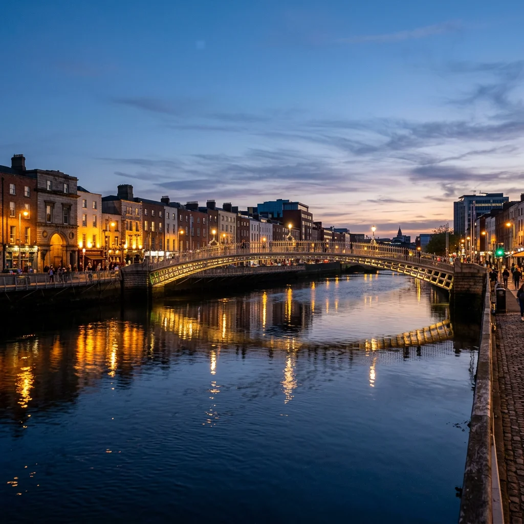
| Ha’penny Bridge | 1816 | Iconic cast-iron footbridge |
Temple Bar is the lively pub quarter, though locals will point you to quieter pubs a few streets away. The Natural History Museum on Merrion Street, nicknamed the “Dead Zoo”, is a Victorian time capsule with giant Irish deer skeletons and whale skeletons hanging from the ceiling.
Seals, porpoises, seabirds and one of Europe’s best urban bird reserves.
- Grey seals and harbour seals around Howth harbour, Ireland’s Eye and Dalkey Island.
- Harbour porpoises in the bay, best seen on calm days from Howth Head.
- Bottlenose and common dolphins occasionally along the coast; see bottlenose dolphin.
- Seabirds: gannets, guillemots, razorbills and kittiwakes on Ireland’s Eye and Lambay Island.
- Bull Island: wintering Brent geese, knot, godwits and oystercatchers in the tens of thousands.
The Howth Cliff Walk loop is the best half-day nature escape from the city, reachable by DART train.
Dublin was a Norse sea town for over 300 years.
Excavations at Wood Quay in the 1970s uncovered Viking houses, ships’ timbers and thousands of artifacts, now partly displayed at the National Museum of Ireland. The Norse built Dublin’s first stone church and minted coins. Their defeat at the Battle of Clontarf in 1014 is a landmark in Irish history, although Norse Dubliners stayed for generations. Dublin’s port still sits at the river mouth they chose.
The excavations at Wood Quay became famous for more than their finds. When Dublin Corporation chose the site for new civic offices, archaeologists and thousands of citizens protested, and the National Museum of Ireland carried out large-scale digs at intervals between 1973 and 1981, led by Pat Wallace. They revealed rows of wattle houses, property boundaries, streets, workshops, combs, shoes, coins and ships’ timbers, preserved in waterlogged soil. The picture that emerged was less of a raiders’ camp than of a prosperous Hiberno-Norse town, where Irish and Scandinavian culture had mixed for generations. The civic offices were built anyway, but the campaign changed attitudes to Ireland’s urban archaeology.
Dublin Bay is about 10 km wide, from Howth Head in the north to Dalkey Point in the south, and runs about 7 km inland to the mouth of the Liffey. It is shallow, with shifting sandbanks, and for centuries it was notorious for shipwrecks, especially in easterly gales, when ships were driven onto the shore between Howth and Dún Laoghaire within sight of land. The bigger problem for trade was silt: two great sandbanks, the North Bull and the South Bull, lay either side of the river mouth, and a sandbar blocked deep-draught ships from reaching the quays.
The solution took more than a century. The Ballast Office was founded in 1707 to manage the harbour, and in 1715 the city authorised an embankment along the South Bull. Wooden piles were driven out into the bay, and between 1761 and 1795 they were replaced by the Great South Wall, built of granite blocks quarried at Dalkey, which runs more than 4 km from Ringsend to the red Poolbeg Lighthouse. It was the longest sea wall in the world when built and is still one of the longest in Europe, and walking it is one of the best free outings in the city. The wall alone did not clear the bar, so the harbour board commissioned surveys, including one in 1801 by Captain William Bligh, of Bounty fame. The engineer George Halpin then built the North Bull Wall from 1820 to 1825, at a cost of £95,000. Squeezed between the two walls, the ebb tide scoured the channel deeper, and the port could at last take large ships. Dublin Port now handles roughly two-thirds of the port traffic of the whole island of Ireland, including the main ferry routes to Holyhead and Liverpool.
The North Bull Wall had an effect nobody fully planned. Sand carried by the currents began to pile up behind it, and within a few decades a new island had formed. North Bull Island is now about 5 km long and up to about 1 km wide, covering nearly 15 km² of dunes, saltmarsh, mudflats and the long beach of Dollymount Strand, all less than 6 km from the city centre. It was designated a UNESCO Biosphere Reserve in 1981, and it carries more nature designations than any other site in Ireland, including national nature reserve, bird sanctuary and EU special protection area. In 2015 the biosphere was extended to cover the whole of Dublin Bay, more than 300 km², with a 50 km² core zone, an 82 km² buffer of parks and green spaces and a 173 km² transition zone in which more than 300,000 people live. Few biosphere reserves anywhere sit so completely inside a capital city.
The island matters most in winter. It lies on the East Atlantic Flyway used by birds travelling between the Canadian Arctic, Greenland and Siberia and the coasts of western Europe and Africa. Light-bellied Brent geese arrive each autumn after a migration of about 5,000 km from Arctic Canada, and long skeins of them commute daily between roosts on Bull Island and feeding grounds on playing fields and parks across north Dublin. They are joined by curlews, godwits, knots, oystercatchers, dunlins and many ducks, which feed on the mudflats at low tide and crowd onto the saltmarsh to roost when the tide rises. The best way to see them is from the causeway road at Raheny around high tide, keeping well back from the saltmarsh edge, because roosting birds are easily disturbed by people and dogs.
Two small islands frame the bay. Ireland’s Eye, 1.2 to 1.5 km off Howth harbour, is reached by seasonal tour boats and holds the ruins of an early church, a Martello tower and nationally important seabird colonies, especially on the Steer sea stack: guillemots, razorbills, kittiwakes and cormorants, with a few puffins and nesting peregrine falcons. Grey seals breed there, and harbour seals and porpoises feed in the surrounding water. At the other end of the bay, Dalkey Island lies about 3 km south of Dún Laoghaire harbour, a five-minute summer ferry ride from Coliemore Harbour. Known for centuries as St Begnet’s Isle, it has the remains of an early church, a gun battery and another Martello tower, and a small herd of feral goats. The rocky sound between the island and the mainland is the best place near Dublin for snorkelling and shore diving, with kelp, wrasse, crabs and the occasional curious seal. A little north, at Sandycove, the Martello tower where the opening scene of James Joyce’s Ulysses is set stands above the Forty Foot, a sea-bathing spot where Dubliners have swum all year round for generations.
Dublin Bay also gave its name to one of Europe’s most valuable shellfish. The “Dublin Bay prawn” is the Norway lobster, Nephrops norvegicus, also sold as langoustine or scampi. It is a slim, pale orange lobster, typically 18 to 20 cm long including claws, that lives in burrows 20 to 30 cm deep in soft mud and comes out mainly at night to feed. The muddy grounds of the Irish Sea support an important fishery for it, and it has been described as the most important commercial crustacean in Europe.
Dublin’s climate is mild, damp and changeable rather than extreme. At the Merrion Square weather station in the city centre, July is the warmest month, with average highs of about 20 °C, and February the coldest, with average lows of about 4 °C. Dublin is sheltered by the Wicklow Mountains to the south and is drier than the west of Ireland, but showers can arrive at any time of year, so a waterproof jacket is worth packing even in summer. Late spring and early summer bring the longest days, with daylight lasting until well after 10 pm in June, and seabird colonies on Ireland’s Eye and Howth Head are at their busiest from about May to July. Autumn and winter are the seasons for the Brent geese and wading birds on Bull Island, and for quieter museums and pubs.
Getting out to the coast is easy without a car. The DART suburban railway runs along the shore of the bay from Howth in the north to Dalkey, Killiney and Bray in the south, and every station along it is close to the sea. Popular half-day trips include the Howth cliff path, the walk along the Great South Wall to Poolbeg Lighthouse, Bull Island at high tide and a summer boat trip to Ireland’s Eye or Dalkey Island. If you swim in the sea, check the local water-quality notices first, because heavy rain can briefly affect some bathing spots, and remember that the Irish Sea rarely rises much above the mid-teens Celsius even in late summer.
- Name: Dubh Linn, “black pool”
- Book of Kells: Illuminated gospel, c. 800
- Guinness lease: 9,000 years, signed 1759
- Literary city: UNESCO City of Literature (2010)
- Nearest dive sites: Dalkey Island and Howth
What is Dublin famous for?
Its Viking origins, Trinity College and the Book of Kells, Guinness, pubs, literature and the 1916 Easter Rising.
How old is Dublin?
Dublin was founded as a Viking settlement around 841, though earlier Irish settlements existed nearby.
What sea is Dublin on?
The Irish Sea, via Dublin Bay.
Can you see seals in Dublin?
Yes. Grey and harbour seals are common around Howth harbour and Dalkey.
How many days do you need in Dublin?
Two to three days for the city, plus a day for Howth or the Wicklow Mountains.
What does Dublin mean?
It comes from the Irish Dubh Linn, meaning black pool.
Is Dublin Bay a protected area?
Yes. North Bull Island was made a UNESCO Biosphere Reserve in 1981, and the reserve was extended to the whole bay, more than 300 km², in 2015.
What is a Dublin Bay prawn?
The Norway lobster (Nephrops norvegicus), also called langoustine or scampi, a small burrowing lobster fished on muddy grounds in the Irish Sea.
- Central Statistics Office Ireland: Census 2022.
- UNESCO Man and the Biosphere: Dublin Bay Biosphere Reserve.
- National Museum of Ireland: Viking Dublin and Wood Quay excavations.
- Trinity College Dublin: The Book of Kells.
- Dublin Bay Biosphere Partnership: About the Biosphere; North Bull Island Nature Reserve.
- Dublin Port Company: history of the Ballast Board, the Great South Wall and the Bull Wall.
- Wallace, P. F. (2016). Viking Dublin: The Wood Quay Excavations. Irish Academic Press.
- Met Éireann: climate averages for Dublin (Merrion Square).
Blane Perun has been exploring Earth’s oceans and marine life for over 25 years. Founder of TheSea.Org in 1999, underwater photographer, coral aquaculture pioneer, and explorer of 80+ countries.
About Blane Perun → More from Europe Atlantic →