Palau Coral Reef Maps — Rock Islands, Blue Corner and a National Sanctuary
Palau’s main reef system is a large barrier reef and lagoon that wraps around the islands of Babeldaob and Koror and the hundreds of forested limestone Rock Islands to the south, ending near Peleliu and Angaur. North of the main lagoon lie Kayangel atoll and the submerged Velasco Reef, and far to the south-west are the remote Southwest Islands and Helen Reef. Famous sites include Blue Corner, German Channel and the Rock Islands’ marine lakes. UNEP-WCMC maps roughly 506 km² of reef, and the Rock Islands Southern Lagoon is a UNESCO World Heritage Site.
Palau is small, but its reefs punch far above their size. Sitting at the eastern edge of the Coral Triangle, where strong currents sweep past steep walls, the country packs barrier reefs, lagoons, channels, atolls and isolated marine lakes into a compact area. It is also one of the world’s best-known examples of a small nation putting reef protection at the centre of national policy. This page maps Palau’s reefs and explains what makes them special.
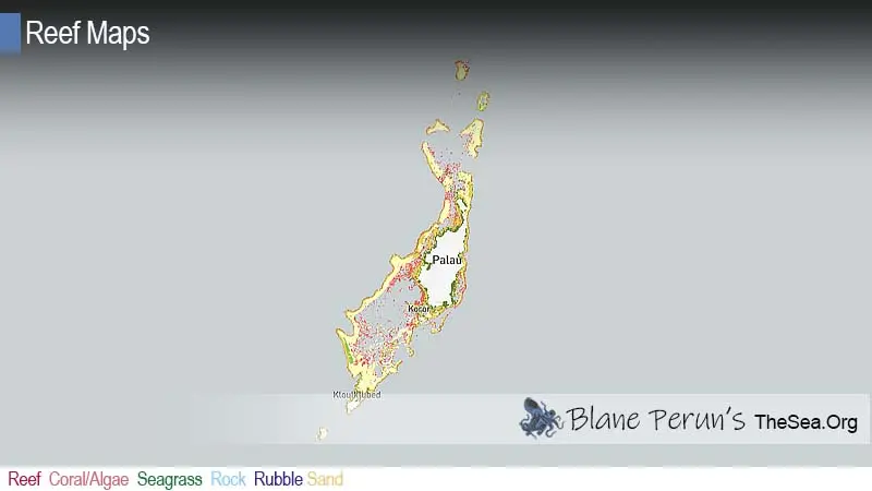
Palau coral reef map
A long barrier reef encloses a lagoon studded with islands, from Kayangel in the north to Peleliu in the south.
On the map, the barrier reef runs along the west side of Babeldaob and curves around to enclose a broad lagoon, while the east coast has a narrower fringing and barrier reef system. South of Koror, the lagoon fills with the scattered Rock Islands, before the reef tapers toward Peleliu and Angaur. At the northern tip lies Kayangel, a classic small atoll, with the broad submerged Velasco Reef beyond it.
The reef outlines come from the UNEP-WCMC global warm-water coral reef dataset, combining satellite imagery and field surveys. Shading shows mapped reef extent, not live coral cover, and the map is a guide rather than a navigation chart.
The Rock Islands and marine lakes
Hundreds of limestone islands made of old reef, set in a living one.
The Rock Islands are made of uplifted ancient reef limestone, covered in dense forest. Waves, chemical erosion and grazing animals such as chitons and sea urchins have undercut them at the waterline, giving many their famous mushroom shape. Between the islands are sheltered coves, coral gardens, sand channels and more than fifty marine lakes — bodies of seawater cut off to varying degrees from the lagoon, each with its own community of life. This mix of features is why the Rock Islands Southern Lagoon was inscribed as a UNESCO World Heritage Site in 2012.
The best known of the marine lakes is Jellyfish Lake on Eil Malk, home to millions of golden jellyfish that migrate across the lake each day following the sun. Isolated for thousands of years, they have only a very mild sting. Their numbers crashed during the drought and heat of 2016, and the lake was closed to visitors until the population recovered, a reminder of how sensitive these isolated ecosystems are.
Blue Corner and Palau’s famous dive sites
Currents, walls and channels bring big fish close to the reef.
Palau’s outer reef drops in sheer walls into deep water, and tidal currents race through the channels that cut the barrier reef. Where currents hit a corner of reef, they concentrate plankton and small fish, attracting predators. The result is some of the most action-packed diving in the world.
- Blue Corner — a reef plateau on the outer wall where divers hook in to watch grey reef sharks, whitetips, barracuda, jacks, Napoleon wrasse and turtles in the current.
- German Channel — a channel cut through the reef in the early twentieth century, now known for reef manta rays visiting cleaning stations.
- Ulong Channel — a drift dive over a channel floor with large lettuce coral formations and schooling fish.
- Peleliu walls and corners — strong-current sites at the southern tip of the reef system.
- Chandelier Cave and WWII wrecks — caverns near Koror and dozens of Japanese wrecks from 1944.
Currents in Palau can be very strong, and many sites are for experienced divers. Learn about coral reef sharks and shipwrecks elsewhere on TheSea.Org.
Why Palau’s reefs are so diverse
A crossroads of currents at the edge of the Coral Triangle.
Palau lies close to the Coral Triangle, the region of Indonesia, the Philippines and Melanesia with the highest marine biodiversity on Earth. Ocean currents carry coral and fish larvae from that region past Palau, and the country’s variety of habitats — exposed walls, sheltered lagoons, seagrass beds, mangroves and marine lakes — gives them many places to settle. As a result, Palau has far more coral and fish species than islands further east in Micronesia, including hundreds of species of hard coral and well over a thousand species of reef fish. For background, see what animals and plants live in coral reefs.
Scientists have also studied Palau’s reefs for clues about resilience. Corals in some of Palau’s sheltered, naturally warmer and more acidic bays, such as Nikko Bay, appear to tolerate conditions that would stress corals elsewhere, and reefs that bleached badly in 1998 showed substantial recovery in later years.
Palau’s conservation model
Traditional closures, a shark sanctuary and one of the largest no-take zones on Earth.
Palau has a long tradition of bul, a customary moratorium declared by traditional leaders to close a reef or fishery so it can recover. Modern protection builds on that foundation. In 2009 Palau declared what is widely described as the world’s first national shark sanctuary. In 2015 it passed the law creating the Palau National Marine Sanctuary, which, once in force from 2020, closed around 80 percent of its exclusive economic zone to commercial fishing and mining, leaving a domestic fishing zone for local needs.
Palau also became one of the first countries to ban sunscreens containing chemicals considered harmful to reefs, from 2020, and since 2017 every visitor has been asked to sign the Palau Pledge, a promise to protect the islands, stamped into their passport. Visitors pay a fee that supports conservation, and permits are required for the Rock Islands.
Threats to Palau’s coral reefs
Even well-protected reefs face heat, runoff and crowds.
Marine heatwaves are the most serious threat: the 1998 El Niño caused severe bleaching and coral death across Palau, and later events have bleached reefs again. Runoff from road building, farming and development on Babeldaob carries sediment into nearshore reefs and mangroves. Tourism pressure at popular sites, from boat anchors to careless fins and crowds in sensitive areas, is managed but persistent. Typhoons, although Palau lies at the southern edge of the typhoon belt, have damaged reefs, as Typhoons Bopha (2012) and Haiyan (2013) did on the eastern reefs. Crown-of-thorns starfish and illegal fishing in remote areas add to the pressures. Ongoing monitoring by the Palau International Coral Reef Center helps track the reefs’ condition. See our reef conservation and can coral reefs recover from bleaching pages.
Related on TheSea
Why is Palau famous for diving?
Palau combines strong currents, steep reef walls and high biodiversity at the edge of the Coral Triangle. Sites such as Blue Corner, German Channel and Ulong Channel bring sharks, manta rays and schooling fish close to divers.
What are the Rock Islands of Palau?
They are hundreds of small, forested islands made of uplifted ancient reef limestone, undercut at the waterline into mushroom shapes. The Rock Islands Southern Lagoon became a UNESCO World Heritage Site in 2012.
Can you still swim in Jellyfish Lake?
Jellyfish Lake closed after the golden jellyfish population crashed in 2016 and later reopened once numbers recovered. Access depends on the jellyfish population and current rules, so check with local authorities before visiting.
What is the Palau National Marine Sanctuary?
It is a no-take marine protected area covering around 80 percent of Palau’s exclusive economic zone, in force since 2020, with a smaller domestic zone kept open for local fishing.
What is the Palau Pledge?
It is a promise, stamped into every visitor’s passport since 2017, to act in an ecologically and culturally responsible way while in Palau.
How much coral reef does Palau have?
UNEP-WCMC maps roughly 506 km² of reef, mostly in the barrier reef and lagoon around the main islands, plus Kayangel, Velasco Reef and the Southwest Islands.
What threatens Palau’s reefs?
Bleaching from marine heatwaves, sediment runoff from Babeldaob, tourism pressure, typhoon damage, crown-of-thorns starfish and illegal fishing in remote waters.
- UNEP-WCMC, WorldFish Centre, WRI, TNC: Global distribution of warm-water coral reefs, v4.1 (2021)
- UNESCO World Heritage Centre: Rock Islands Southern Lagoon
- Palau National Marine Sanctuary Act (2015)
- Palau International Coral Reef Center: reef monitoring reports
Blane Perun has been exploring Earth’s oceans and marine life for over 25 years. Founder of TheSea.Org in 1999, underwater photographer, coral aquaculture pioneer, and explorer of 80+ countries.
About Blane Perun → More Oceania Coral Reef Maps →