Vanuatu Coral Reef Maps — Volcanic Islands, Fringing Reefs and the Coolidge
Vanuatu’s coral reefs are mostly fringing reefs that hug the coasts of its roughly 80 volcanic islands, a Y-shaped chain running some 1,300 km through the south-western Pacific. The best-known reef areas are around Espiritu Santo, the largest island, home to the SS President Coolidge wreck and Million Dollar Point; Efate, with the capital Port Vila and Mele and Havannah bays; Malekula and its offshore islands; Epi, known for dugongs; and Tanna in the south. Because the islands rise steeply from deep water, reefs are narrow and often reachable straight from the beach. UNEP-WCMC maps roughly 707 km² of reef.
Vanuatu sits on one of the most active plate boundaries on Earth. Volcanoes smoke on several islands, earthquakes are frequent, and severe cyclones cross the archipelago regularly. Its reefs have grown up in this restless setting, clinging to steep volcanic shores and being periodically lifted, battered and rebuilt. This page maps Vanuatu’s reefs, highlights the main areas and explains the forces that shape them.
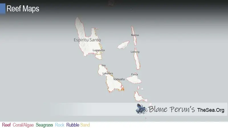
Vanuatu coral reef map
Narrow fringing reefs trace the coasts of a long volcanic chain.
On the map, reefs appear as thin bands along island coastlines rather than as broad lagoons. The northern Torres and Banks islands, the large central islands of Espiritu Santo, Malekula, Ambae, Pentecost and Ambrym, the Shepherd Islands and Efate, and the southern islands of Erromango, Tanna and Aneityum all carry fringing reef. The widest reef areas are in sheltered bays and channels, such as Santo’s south-east coast and the bays around Efate.
The reef outlines come from the UNEP-WCMC global warm-water coral reef dataset, combining satellite imagery and field surveys. Shading shows mapped reef extent, not live coral cover, and the map is a guide rather than a navigation chart.
A volcanic archipelago shapes its reefs
Steep, young islands leave little room for wide lagoons.
Vanuatu’s islands were built by volcanoes along the boundary where the Australian plate dives beneath the Pacific plate. They are geologically young and rise steeply from deep water, so there is little shallow shelf for reefs to spread across. The result is narrow fringing reefs rather than the barrier reefs and lagoons of older, subsided islands such as those of Fiji or New Caledonia.
The same tectonics lift and drop the land. On several islands, old coral reefs have been raised into limestone terraces stepping up the hillsides, and large earthquakes have pushed living reef flats out of the water, killing the coral there. Active volcanoes such as Mount Yasur on Tanna and the volcanoes of Ambrym and Ambae add ash and lava to the mix. See how coral reefs are formed.
The SS President Coolidge and Million Dollar Point
One of the world’s great wreck dives, reachable from the beach.
The SS President Coolidge was an American luxury liner converted to a troopship in the Second World War. In October 1942 it struck mines at the entrance to the harbour at Luganville on Espiritu Santo and was run aground; almost everyone on board got ashore before it slipped down the reef slope. The wreck now lies on its side from shallow to deep water, close enough to shore that divers walk in from the beach. Its holds, promenade decks and fittings are encrusted with coral and full of fish, and it is among the largest wrecks accessible to recreational divers anywhere.
Nearby, Million Dollar Point is where US forces dumped huge quantities of vehicles and equipment into the sea at the end of the war. The heap of machinery is now an artificial reef. See our shipwrecks section for more wreck sites.
Vanuatu’s main reef areas
Each island has its own reef character.
- Espiritu Santo — the Coolidge, Million Dollar Point, reef-fringed islands off the south-east coast and blue holes inland.
- Efate — Mele Bay, Hideaway Island marine reserve (with its underwater post box), Havannah Harbour and outer-reef dives near Port Vila.
- Malekula and its islands — remote fringing reefs and the Maskelyne Islands, known for community-managed reefs.
- Epi — Lamen Bay, where dugongs graze in seagrass close to shore.
- Tanna and the south — fringing reefs below active volcanoes; Aneityum’s reefs in the far south.
Reef life in Vanuatu
Western Pacific reef life, with dugongs, turtles and big walls.
Vanuatu’s reefs carry a rich western Pacific fauna, with many species of hard and soft coral, sea fans on steep walls, and reef fish such as parrotfish, surgeonfish, butterflyfish, anthias, groupers and trevally. Green and hawksbill turtles are common, reef sharks patrol outer slopes, and dugongs feed in seagrass beds at sites such as Lamen Bay. Mangroves and seagrass along sheltered coasts act as nurseries for reef fish and crustaceans. For more, see what animals and plants live in coral reefs.
Reefs and island life
Food, custom and a growing tourism industry.
Most ni-Vanuatu live in rural coastal villages, where reef fish, shellfish, octopus and seaweed are everyday food. Reefs also shield villages from waves and storms. Reef and wreck tourism is concentrated on Efate and Santo, bringing income to resorts and dive operators and, through reef fees and community partnerships, to some villages. Vanuatu has also taken a strong environmental stance, banning several single-use plastics in 2018 and leading the push for an International Court of Justice advisory opinion on states’ climate obligations.
Diving and snorkelling in Vanuatu
Shore entries, walls and wrecks, with the best infrastructure on Efate and Santo.
Because reefs sit close to shore, much of Vanuatu’s best snorkelling starts from the beach. On Efate, Hideaway Island and the reefs of Mele Bay are popular, and boat dives near Port Vila visit walls, caverns and small wrecks. On Santo, the Coolidge is a series of dives in itself, progressing deeper and further into the ship, and is best done with local guides who know its layout. The outer islands offer remote, uncrowded reefs but few facilities, and visitors usually pay a small custom fee to the reef owners.
- Ask before entering — reefs belong to communities, and some areas are tabu.
- Plan wreck dives carefully — the Coolidge is large and deep in parts; dive within your training.
- Watch the weather — the cyclone season runs roughly from November to April.
- Leave coral and shells — collecting damages reefs and can breach local rules.
Threats to Vanuatu’s coral reefs
Cyclones and earthquakes on top of local and global pressures.
Cyclones are a major and growing threat: Cyclone Pam in 2015 caused devastating damage, and in 2023 Cyclones Judy and Kevin struck within days of each other. Storm waves break up shallow coral and runoff smothers reefs. Earthquakes can lift or bury reefs, as the December 2024 earthquake near Port Vila was a reminder. Overfishing near growing towns, coastal development and pollution around Port Vila and Luganville, crown-of-thorns starfish outbreaks and marine heatwaves causing bleaching all add pressure. Customary tabu areas and community reserves help reefs recover between disturbances. See our reef conservation and coral reef bleaching pages.
Related on TheSea
Does Vanuatu have coral reefs?
Yes. Fringing reefs line most of its roughly 80 volcanic islands. UNEP-WCMC maps roughly 707 km² of reef.
Where is the SS President Coolidge?
The Coolidge lies just off the shore near Luganville on Espiritu Santo, where it sank after striking mines in October 1942. Divers can enter from the beach.
Where is the best snorkelling in Vanuatu?
Hideaway Island and Mele Bay on Efate, the islands off south-east Santo, and Lamen Bay on Epi, where dugongs are sometimes seen, are among the best-known spots.
Why doesn’t Vanuatu have big lagoons?
Its islands are young and volcanic and rise steeply from deep water, leaving little shallow shelf. Reefs therefore form narrow fringes along the shore rather than wide barrier reefs and lagoons.
Can you see dugongs in Vanuatu?
Yes. Dugongs graze in seagrass beds at several places, most famously Lamen Bay on Epi.
What threatens coral reefs in Vanuatu?
Severe cyclones, earthquakes, overfishing, coastal development and pollution, crown-of-thorns starfish and bleaching from marine heatwaves.
- UNEP-WCMC, WorldFish Centre, WRI, TNC: Global distribution of warm-water coral reefs, v4.1 (2021)
- Vanuatu Fisheries Department: community-based fisheries management
- Pacific Community (SPC): Vanuatu post-cyclone reef and fisheries assessments
Blane Perun has been exploring Earth’s oceans and marine life for over 25 years. Founder of TheSea.Org in 1999, underwater photographer, coral aquaculture pioneer, and explorer of 80+ countries.
About Blane Perun → More Oceania Coral Reef Maps →