Samoa Coral Reef Maps — Fringing Reefs and Lagoons of Upolu and Savai’i
Samoa’s coral reefs are mainly fringing reefs around its two large volcanic islands, Upolu and Savai’i, and the small islands of Manono and Apolima in the strait between them. Reef flats and shallow lagoons line much of the coast, widest along parts of Upolu’s south and east, where the Aleipata and Safata marine protected areas lie, and off Apia, where the Palolo Deep marine reserve has a reef drop-off a short swim from shore. UNEP-WCMC maps roughly 200 km² of reef. This page covers independent Samoa; American Samoa is a separate US territory with its own reefs.
Samoa’s reefs are not vast barrier systems, but they are woven into everyday life to an unusual degree. Most Samoans live in coastal villages that face directly onto a reef flat and lagoon, and those villages hold traditional authority over the reef in front of them. This page maps Samoa’s reefs, describes the main reef areas and looks at how village-based management is helping protect them.
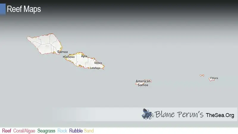
Samoa coral reef map
Fringing reefs hug the coasts of two volcanic islands.
On the map, coral shading traces much of Upolu’s coastline and large parts of Savai’i’s, with wider reef flats and lagoons in sheltered bays. Gaps appear where young lava flows meet the sea on Savai’i, along steep cliffs, and at river mouths. Manono and Apolima sit on the reef platform in the Apolima Strait between the two main islands. American Samoa’s islands lie off the map to the east.
The reef outlines come from the UNEP-WCMC global warm-water coral reef dataset, combining satellite imagery and field surveys. Shading shows mapped reef extent, not live coral cover, and the map is a guide, not a navigation chart.
Why Samoa has fringing reefs
Young volcanic islands have reefs that hug the shore.
Upolu and Savai’i are volcanic islands built by eruptions over the last few million years, and Savai’i is still volcanically active: lava flows from the Matavanu eruption of 1905–1911 buried villages and reached the sea on its north coast. On young, high islands like these, coral grows as fringing reef close to shore, with a reef flat and shallow lagoon behind a breaking reef crest. Over much longer time, as volcanic islands subside, fringing reefs can become barrier reefs and eventually atolls — a sequence visible across the Pacific. See how coral reefs are formed.
Samoa’s main reef areas
From city-edge reserves to remote lava coasts.
- Palolo Deep (Apia) — a small marine reserve where you can wade across a reef flat to a deep blue hole lined with coral; one of the easiest snorkels in the Pacific.
- Aleipata (eastern Upolu) — a broad lagoon with offshore islets such as Nu’utele and Nu’ulua, protected as a district marine protected area.
- Safata (southern Upolu) — a large community-managed marine protected area with lagoon, mangroves and reef.
- Upolu south coast — lagoons, beaches and the To Sua Ocean Trench, a collapsed lava cave connected to the sea.
- Savai’i — fringing reefs, lava coasts and blowholes such as Alofaaga; turtle-viewing pools in some villages.
- Manono and Apolima — small islands with reef flats and village fishing grounds in the strait.
Reef life in Samoa
Polynesian reef communities, and one famous worm.
Samoa’s reefs support corals such as Acropora, Pocillopora, Porites and Montipora, with reef fish including parrotfish, surgeonfish, butterflyfish, damselfish, groupers and trevally. Green and hawksbill turtles feed on the reefs, reef sharks and eagle rays patrol the edges, and humpback whales pass offshore in the southern winter. Giant clams have been restocked in some village reserves. For more, see what animals and plants live in coral reefs.
Village fisheries management
Fa’a Samoa meets modern reef science.
Under fa’a Samoa, the Samoan way, village councils of chiefs hold authority over the lagoon and reef next to their village. Since the mid-1990s, Samoa’s fisheries agency has worked with villages to turn that authority into formal fisheries management plans. Participating villages set their own rules, such as bans on destructive fishing, limits on undersized fish and no-take fish reserves, and many have restocked giant clams. These village reserves sit alongside larger marine protected areas at Aleipata and Safata and the Palolo Deep reserve, creating one of the Pacific’s best-known networks of community-managed reefs.
Mangroves, seagrass and the reef
The reef works as part of a connected coastal system.
Samoa’s reefs do not stand alone. Mangrove stands in sheltered bays, such as those within the Safata marine protected area and around parts of Upolu’s coast, trap sediment washing off the land and shelter juvenile fish and crabs. Seagrass beds in the lagoons feed turtles and provide nursery grounds for species that later move onto the reef. Freshwater springs that emerge along the coast, a feature of porous volcanic islands, create brackish pools that villages have used for bathing for generations.
Because these habitats are linked, damage in one spreads to the others. Clearing mangroves or filling coastal wetlands lets more sediment reach the reef; overfishing herbivorous fish allows algae to smother corals; and polluted runoff fuels algae in the lagoon. Many village management plans therefore protect mangroves and seagrass alongside the reef itself, and some communities have replanted mangroves after cyclones and the 2009 tsunami.
Snorkelling and diving in Samoa
Gentle lagoon snorkelling, with diving off the outer reef.
Most visitors explore Samoa’s reefs from the beach. Palolo Deep in Apia, the Aleipata lagoon and many south-coast beaches offer calm, shallow snorkelling inside the reef crest. Dive operators on Upolu and Savai’i run boat trips to outer reef slopes and passes, where visibility is better and larger fish are more common. Many beaches belong to villages that charge a small access fee and have rules on Sundays and dress; ask locally before swimming or fishing. Stay inside the reef unless with a guide, as passes can have strong outgoing currents.
Threats to Samoa’s coral reefs
Storms, a tsunami, crowding near Apia and a warming sea.
Cyclones have repeatedly damaged Samoa’s reefs, including Ofa (1990), Val (1991) and Evan (2012). The 2009 tsunami devastated the Aleipata coast of Upolu, scouring lagoons and reefs as well as destroying villages. Crown-of-thorns starfish outbreaks have killed coral in the past. Overfishing on village reef flats, runoff from steep cultivated slopes and pollution near Apia reduce reef health, and marine heatwaves bring bleaching. Samoa’s village reserves and protected areas give reefs a better chance to recover between these shocks. See our reef conservation and coral reef bleaching pages.
Related on TheSea
Does Samoa have coral reefs?
Yes. Fringing reefs and lagoons line much of the coasts of Upolu and Savai’i. UNEP-WCMC maps roughly 200 km² of reef.
Where is the best snorkelling in Samoa?
Palolo Deep marine reserve in Apia, the Aleipata lagoon on eastern Upolu and sheltered south-coast lagoons are the most popular spots.
What is Palolo Deep?
Palolo Deep is a small marine reserve near Apia where a short wade across the reef flat leads to a deep, coral-lined hole full of reef fish.
Are Samoa and American Samoa the same?
No. Samoa is an independent country made up of Upolu, Savai’i and smaller islands. American Samoa, to the east, is a US territory with its own reefs, including those of Tutuila and the Manu’a Islands.
What is the palolo worm?
It is a reef-dwelling worm whose reproductive segments swarm to the surface once a year, usually in October or November. Samoans gather them as a delicacy.
What threatens coral reefs in Samoa?
Cyclones, tsunamis, crown-of-thorns starfish, overfishing, runoff and pollution, and bleaching from marine heatwaves.
- UNEP-WCMC, WorldFish Centre, WRI, TNC: Global distribution of warm-water coral reefs, v4.1 (2021)
- Samoa Ministry of Agriculture and Fisheries: Community-Based Fisheries Management Programme
- Samoa Ministry of Natural Resources and Environment: Aleipata and Safata marine protected areas
Blane Perun has been exploring Earth’s oceans and marine life for over 25 years. Founder of TheSea.Org in 1999, underwater photographer, coral aquaculture pioneer, and explorer of 80+ countries.
About Blane Perun → More Oceania Coral Reef Maps →