Papua New Guinea Coral Reef Maps — Reefs at the Edge of the Coral Triangle
Papua New Guinea’s coral reefs fringe much of its mainland coast and surround its hundreds of islands in the Bismarck Sea, Solomon Sea and Coral Sea. The best-known reef regions are Kimbe Bay and Rabaul on New Britain, Kavieng and the islands of New Ireland, Milne Bay and the Louisiade Archipelago in the far south-east, the Madang coast, the Admiralty Islands around Manus, and the islands of Bougainville. PNG lies within the Coral Triangle, the global centre of marine biodiversity, and UNEP-WCMC maps roughly 8,300 km² of reef — by far the largest reef area of any Pacific island nation.
Papua New Guinea is one of the great reef nations of the world, yet its reefs are far less visited than those of Australia, Indonesia or the Philippines. Long coastlines, scattered islands, rugged terrain and limited infrastructure mean that many reefs are known mainly to the coastal communities who own and fish them. This page maps PNG’s reefs, explains why they are so diverse and looks at the pressures they face.
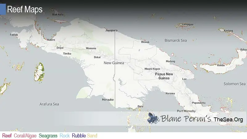
Papua New Guinea coral reef map
Reef wraps the mainland and the island arcs of the Bismarck and Solomon Seas.
On the map, coral shading follows much of the northern and eastern mainland coast and wraps around the large islands of New Britain, New Ireland, Manus and Bougainville. The densest concentrations appear in the island arcs of the Bismarck Sea and in the south-east, where Milne Bay and the Louisiade Archipelago break into hundreds of reef-ringed islands. Reefs are sparse along the Gulf of Papua in the south, where the great Fly and Purari rivers pour huge volumes of muddy water into the sea.
The reef outlines are taken from the UNEP-WCMC global warm-water coral reef dataset, which combines satellite imagery and field surveys. Shading shows mapped reef extent, not live coral cover, and many reefs in PNG remain poorly surveyed. The map is a guide, not a navigation chart.
Why PNG’s reefs are so diverse
The Coral Triangle is the world’s centre of reef biodiversity, and PNG forms its eastern edge.
The Coral Triangle spans Indonesia, the Philippines, Malaysia, Timor-Leste, Papua New Guinea and the Solomon Islands, and contains more species of reef-building coral and reef fish than any other marine region. Several factors combine to create this richness: warm, stable seas; a complex geology of island arcs, deep basins and shallow shelves; and ocean currents that link the Pacific and Indian Oceans. PNG’s seas have every habitat in this mix, from sheltered bays and mangrove-lined inlets to steep oceanic walls and remote atolls.
Because larvae drift on currents from reef to reef, healthy reefs in places such as PNG help supply young corals and fish to reefs downstream. That makes their protection important well beyond national borders. PNG is a member of the regional Coral Triangle Initiative, launched in 2009 to coordinate conservation among the six Coral Triangle countries.
Kimbe Bay and New Britain
Volcanic seamounts, deep water and coral diversity close to shore.
Kimbe Bay, on the north coast of New Britain, is one of the most celebrated reef areas in the Pacific. Deep water lies close to shore, and dozens of submerged seamounts and pinnacles rise from the depths, covered in hard and soft corals, sea fans and sponges. Surveys have recorded several hundred species of hard coral and a very large variety of reef fish in the bay, along with dolphins, pilot whales and occasional orcas offshore. The Nature Conservancy and local communities worked together here to design one of the first networks of marine protected areas planned around how reefs are connected by currents.
At the eastern end of New Britain, Rabaul combines active volcanoes with reefs and a harbour full of Second World War wrecks, reflecting its role as a major Japanese base.
Milne Bay, Madang, New Ireland and beyond
Each region has its own reef character, from muck diving to big-fish passages.
- Milne Bay and the Louisiades — at the eastern tip of the mainland, a maze of islands, fringing reefs and atolls; Milne Bay is famous for “muck diving” on sandy and silty slopes rich in unusual small animals such as frogfish, ghost pipefish and nudibranchs.
- Madang — on the north coast, a lagoon of islands and fringing reefs with WWII aircraft and ship wrecks close to town.
- Kavieng and New Ireland — channels between islands with strong currents, schools of barracuda and trevally, reef sharks and wreckage from the war.
- Manus and the Admiralty Islands — remote reefs and lagoons in the north, with dugongs in seagrass beds.
- Tufi (Oro Province) — drowned volcanic valleys, or fjords, with reefs at their mouths.
- Bougainville — reef-fringed islands in the east, close to the Solomon Islands.
Reef life in Papua New Guinea
From giant sea fans to tiny pygmy seahorses.
PNG’s reefs support an extraordinary range of life. Walls are covered in sea fans, whip corals, sponges and soft corals; slopes hold extensive hard coral gardens; and sandy or silty areas host a surprising number of small, cryptic species such as pygmy seahorses, mantis shrimp and rare nudibranchs. Larger animals include grey reef, whitetip and silvertip sharks, manta and eagle rays, turtles, dugongs and several species of dolphin and whale. Leatherback turtles nest on some PNG beaches, among the most important remaining nesting areas for the western Pacific population. For more, see what animals and plants live in coral reefs.
Reefs and coastal communities
For hundreds of thousands of people, the reef is the main source of protein.
Most coastal Papua New Guineans live in villages that depend on reef fish, shellfish, sea cucumbers and other marine resources for food and income. Reefs also protect low-lying coasts from waves, and mangroves and seagrass beds act as nurseries for fish. Reef tourism is small and concentrated in a handful of destinations, so the main economic value of most reefs lies in subsistence fishing and small-scale trade.
Threats to Papua New Guinea’s reefs
Land-based pollution and fishing pressure are growing alongside a warming ocean.
Sedimentation from logging, land clearing and road building washes onto nearshore reefs, especially near river mouths. Mining brings risks of pollution, and some mines have disposed of waste tailings into the sea. Overfishing is increasing near growing towns, and destructive practices such as fishing with explosives or poisons occur in places. Overharvesting of sea cucumbers for export has led to periodic fishery closures. Marine heatwaves have bleached reefs in PNG, as across the region, and crown-of-thorns starfish outbreaks affect some areas. On the positive side, PNG’s customary tenure and network of community-managed areas give it strong local tools for protection. See our reef conservation and coral reef bleaching pages.
Related on TheSea
Does Papua New Guinea have coral reefs?
Yes, extensive ones. Reefs fringe much of the mainland and surround its many islands. UNEP-WCMC maps roughly 8,300 km² of reef, the largest area of any Pacific island country.
Is Papua New Guinea part of the Coral Triangle?
Yes. PNG forms the eastern part of the Coral Triangle, together with Indonesia, the Philippines, Malaysia, Timor-Leste and the Solomon Islands — the region with the highest reef biodiversity on Earth.
Where is the best diving in Papua New Guinea?
Kimbe Bay on New Britain, Milne Bay, Kavieng in New Ireland, Madang and Rabaul are the best-known areas, each offering different experiences from seamounts and walls to muck diving and WWII wrecks.
What is muck diving in Milne Bay?
Muck diving means exploring sandy or silty slopes for small, unusual animals such as frogfish, ghost pipefish, octopus and nudibranchs. Milne Bay is one of the places where the style became famous.
Who owns the reefs in Papua New Guinea?
Most reefs are owned under customary tenure by clans and villages. Visitors often pay reef fees, and communities can set their own fishing rules and no-take areas.
What threatens coral reefs in Papua New Guinea?
Sediment from logging and land clearing, mining pollution, overfishing and destructive fishing, marine heatwaves and crown-of-thorns starfish outbreaks.
- UNEP-WCMC, WorldFish Centre, WRI, TNC: Global distribution of warm-water coral reefs, v4.1 (2021)
- Coral Triangle Initiative on Coral Reefs, Fisheries and Food Security (CTI-CFF)
- The Nature Conservancy: Kimbe Bay marine protected area network design
Blane Perun has been exploring Earth’s oceans and marine life for over 25 years. Founder of TheSea.Org in 1999, underwater photographer, coral aquaculture pioneer, and explorer of 80+ countries.
About Blane Perun → More Oceania Coral Reef Maps →