Coral Reef Underwater Park Trails — Map & Guide to Snorkel Trails in the Caribbean and Florida
A coral reef underwater park trail is a marked snorkelling route through a living reef, usually inside a national park or marine protected area. Underwater signs, plaques, buoys or a guide line lead swimmers along a set path and identify the corals, fish and other reef life they pass, turning an ordinary snorkel into a self-guided nature walk under the sea. The idea was pioneered in the US Virgin Islands — at Trunk Bay on St John and at Buck Island Reef off St Croix — and has since spread to reef parks across the Caribbean and the Florida Keys. The map below shows where some of the best-known trails lie.
Most people meet their first coral reef from the surface, face down in a mask, with no idea what they are looking at. An underwater park trail changes that. By laying a marked route across a shallow reef and labelling what lives there, a park can turn a confusing blur of colour into a lesson in reef ecology — and, just as importantly, keep hundreds of visiting snorkellers on a path that the reef can tolerate. This guide explains what underwater trails are, where the most famous ones are found in the Caribbean and Florida, how to snorkel one well, and why these small, carefully managed routes matter so much for reef conservation.
What is an underwater park trail?
An underwater trail is the marine version of a nature trail: a fixed route through a reef, with interpretation along the way.
On land, a nature trail is a path with signposts that tell walkers which tree they are looking at and why it matters. An underwater park trail does the same thing on a coral reef. Typically a series of plaques or markers is fixed to the sea floor or to blocks of rock along a chosen route. Each one names a coral, a fish or a reef feature and adds a line or two of explanation. Snorkellers follow the markers from one station to the next, reading as they float overhead, so a short swim becomes a self-guided tour.
Not every trail uses fixed signs. Some parks mark the route with surface buoys or a guide rope, hand out waterproof identification cards, or rely on guided snorkel tours that follow a set path. Others mark the start of shore-diving sites so that visitors can find the reef without damaging it. What they all share is the same basic idea: put a clear, managed route across a reef that people can enjoy without needing a boat captain, a dive certification or a marine-biology degree.
Trails are usually laid out over shallow, sheltered reef where the water is calm and clear and where most swimmers can see the bottom from the surface. That makes them ideal for families and nervous beginners, and it is why so many of them sit just off a beach. The trade-off is that shallow reefs are also the most vulnerable to careless fins and hands, which is exactly why careful route design and visitor education matter.
Map of underwater reef trails in the Caribbean and Florida
The map marks some of the best-known underwater reef trails against the mapped coral reefs of the Caribbean and Florida.
The reef shapes on this map come from the global coral-reef dataset compiled by UNEP-WCMC, traced from satellite imagery and field surveys, so the coral shading shows real, mapped reef extent. The labelled sites mark some of the region’s best-known underwater trails, from the US Virgin Islands in the east to the Florida Keys in the west. Reading the map this way makes one thing obvious: trails are tiny compared with the reefs around them. They are deliberate windows onto a much larger system, placed where access is easy and the reef can be watched over.
For the reefs of individual islands and countries, see our US Virgin Islands coral reef map, the Caribbean coral reef maps overview and the map of coral reefs in Florida.
Trunk Bay, St John — the classic snorkel trail
The underwater trail at Trunk Bay, inside Virgin Islands National Park, is the reef trail most people have heard of.
Trunk Bay sits on the north shore of St John, an island largely protected as Virgin Islands National Park, which was established in 1956. The bay is famous for its white sand beach and turquoise water, but its real claim to fame lies just offshore, around a small rocky cay. There the park laid out an underwater snorkel trail, with submerged signs placed along a route over the shallow reef. Swimmers follow the markers around the cay, reading about the corals, sea fans and fish they are looking at.
The appeal of Trunk Bay is how little it demands of visitors. There is no boat ride, no deep water and, on a calm day, very little current. A swimmer can walk in from the beach, follow the trail for a short loop and be back on the sand within an hour. For generations of visitors that loop has been a first introduction to a living coral reef, and the idea of labelling a reef for the public was copied widely as a result.
That popularity has a cost. Trunk Bay is one of the busiest beaches in the Virgin Islands, and its shallow reef has suffered from the same regional stresses — bleaching, disease and storm damage — that have affected reefs across the Caribbean. Visitors today will see a reef that is still well worth the swim, but one that depends on careful behaviour from every snorkeller who passes over it.
Buck Island Reef, St Croix — a barrier-reef trail
Off the north-east coast of St Croix, Buck Island Reef National Monument protects a small island ringed by reef, with a marked underwater trail on its eastern side.
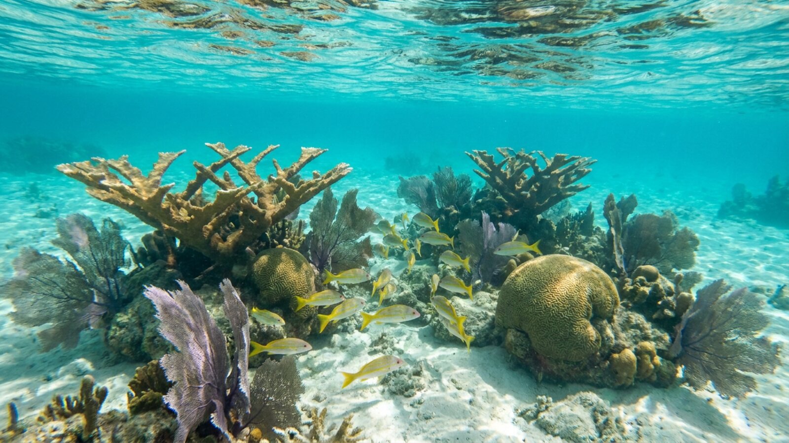
Buck Island Reef National Monument was proclaimed in 1961 to protect one of the finest reef systems in the Caribbean, and it was later enlarged to cover much more of the surrounding sea. The island itself is small and uninhabited; the reason people go is the reef that wraps around it, historically dominated by thickets of elkhorn coral, Acropora palmata, a branching coral that once built shallow reef crests across the region.
Visitors reach Buck Island by licensed boat from Christiansted. The underwater trail is laid out in the sheltered lagoon behind the reef, where markers guide snorkellers through channels between coral formations. Because it is set inside a lagoon protected by a barrier reef, the trail shows something Trunk Bay cannot: the structure of a true barrier reef, with its shallow back-reef, coral heads and grottoes, and the open sea breaking on the far side.
Like elsewhere in the Caribbean, elkhorn coral at Buck Island suffered heavy losses from disease and bleaching in recent decades. The monument’s protection gives the reef the best chance of recovery, and restoration work across the region is focused on exactly this kind of shallow, high-value habitat.
| Trail or site | Where | Known for |
|---|---|---|
| Trunk Bay underwater trail | St John, US Virgin Islands | Classic beach-access snorkel trail in a national park |
| Buck Island Reef | St Croix, US Virgin Islands | Marked trail in a barrier-reef lagoon; national monument |
| John Pennekamp Coral Reef State Park | Key Largo, Florida Keys | First undersea park in the US; boat-access reef snorkelling |
| Biscayne National Park | South Florida | Underwater heritage trail of shipwrecks on the reef |
| Bonaire shore-diving sites | Dutch Caribbean | Roadside markers for dozens of shore-entry reef sites |
| Marine-park snorkel routes | Across the Caribbean | Buoyed or guided routes inside protected reefs |
Underwater trails in Florida
Florida has the only extensive living coral barrier reef in the continental United States, and its parks were among the first to open reefs to the public.
John Pennekamp Coral Reef State Park on Key Largo was dedicated in 1963 as the first undersea park in the United States. Its reefs lie several miles offshore, so most visitors reach them by snorkel or glass-bottom boat tours from the park marina rather than from the beach. Sites such as Grecian Rocks and Key Largo Dry Rocks, home of the famous Christ of the Abyss statue, function as underwater trails in practice: well-known, buoyed reefs where boats tie up to mooring balls and snorkellers are guided over the shallowest coral. See our John Pennekamp snorkeling guide for detail.
Further north, Biscayne National Park protects the northern end of the Florida Reef Tract. Here the park created an underwater heritage trail linking shipwrecks that lie on and around the reef, with markers that explain each wreck’s history. It is a reminder that reefs have always been hazards to shipping as well as habitats, and that many Florida wrecks have themselves become artificial reefs crusted with coral and sponges.
The rest of the Keys reef is protected within the Florida Keys National Marine Sanctuary, which uses mooring buoys, zoning and visitor education to manage heavy use. Popular snorkel reefs off Key Largo, Islamorada, Marathon and Key West are not trails in the formal sense, but they work in a similar way: fixed moorings concentrate boats in known spots, and dive operators brief guests on reef etiquette before they enter the water. Far to the west, the moat wall around Fort Jefferson in Dry Tortugas National Park offers a gentle shore snorkel that many visitors treat as a trail of its own. Our best snorkeling in the Florida Keys guide covers these sites in more depth.
Reef trails across the wider Caribbean
The idea pioneered in the Virgin Islands now shows up in many forms across Caribbean marine parks.
On Bonaire, almost the entire coastline is protected as a marine park, and the island has built its reputation on shore diving and snorkelling. Instead of a single trail, dozens of named reef sites are marked along the coastal road, traditionally with painted yellow stones, so visitors can park, wade in and reach the reef without a boat. Visitors are given an orientation on reef rules, and the result is a coastline-long network of access points that works like a trail system. Our Bonaire snorkelling guide and Dutch Caribbean reef map cover the island in more detail.
Elsewhere, marine parks in places such as the Bahamas, the Cayman Islands, Belize and the Lesser Antilles use buoyed snorkel areas, guided routes and mooring systems that serve the same purpose. Some resorts and community groups have also created small interpretive trails over nearshore reefs or seagrass beds. The format varies, but the principle holds: steer people to a reef they can enjoy, explain what they are seeing, and keep them away from the most fragile coral.
If you are choosing where to snorkel, our guides to the best snorkeling in the Caribbean and the best snorkeling in St Thomas are good places to start.
How to snorkel an underwater trail
Reef trails are designed for beginners, but a little preparation makes the experience better for you and for the reef.
Practise in the sand first. Before heading over coral, spend a few minutes in shallow water over sand, clearing your mask and snorkel and getting comfortable floating face down. Most reef damage on trails happens when a swimmer panics, stands up and plants a fin on living coral.
Float, don’t stand. Coral may look like rock, but the surface is a thin layer of living animals. Standing, kneeling or holding on crushes polyps and opens wounds where disease can take hold. If you need to rest, roll onto your back and float, or swim back to sand. A snorkel vest makes this easy for less confident swimmers.
Mind your fins. Long fins kick up sand and strike coral without the swimmer noticing. Keep kicks slow and near the surface, and be especially careful when turning around or reading a sign.
Use reef-friendly sun protection. A rash guard or wetsuit top cuts the amount of sunscreen that washes into the water. Several Caribbean destinations and parts of Florida have rules on certain sunscreen ingredients, so check local guidance before you go.
Look but don’t take. Shells, sea fans and coral fragments are protected in parks, and feeding fish changes their behaviour. The best souvenirs are photographs.
Why reef trails matter for conservation
Underwater trails are not just attractions. They are a deliberate management tool that balances public access with reef protection.
The first benefit is education. Most people will never read a scientific paper on reef decline, but they may well remember the sign that told them a sea fan is an animal, or that a parrotfish produces sand. Trails turn a passive swim into a lesson and help build public support for protecting reefs. That support matters when parks need funding, when fishing rules are debated, or when coastal development threatens water quality.
The second benefit is containment. By concentrating visitors on a known route, providing mooring buoys instead of anchors, and setting trails inside protected areas, managers can accept that a small section of reef will be heavily used while sparing the rest. It is the same logic as a boardwalk through a wetland: a little sacrifice in one place to protect the whole.
The third benefit is monitoring. Because trail reefs are visited constantly and watched closely by rangers, guides and repeat visitors, changes such as bleaching, disease outbreaks or storm damage are noticed quickly. Popular trails often become places where restoration projects, such as outplanting nursery-grown corals, are trialled and shown to the public.
Pressures on reef-trail reefs
Trail reefs face every threat that other Caribbean reefs face, plus the pressure of constant visitors.
Across the region, coral cover has declined sharply since the late twentieth century. Warming seas cause repeated mass bleaching; outbreaks of coral disease, including stony coral tissue loss disease, have killed many reef-building species; and pollution, sediment and overfishing weaken reefs further. The die-off of the long-spined sea urchin in the early 1980s removed a key grazer and allowed seaweed to spread over many reefs. Hurricanes add sudden physical damage on top.
Heavy use adds local stresses: trampling and fin strikes, sunscreen and other chemicals washing into shallow water, boat traffic and anchor damage where moorings are absent. Parks respond with marked routes, mooring buoys, visitor briefings, limits on numbers at busy sites and, in some places, temporary closures to let reefs recover. Learn more on our coral reef threats and coral reef conservation pages.
None of this means you should avoid reef trails. Used well, they are among the best ways to see a reef responsibly. The point is that every visitor is part of the management plan: the way you float, kick and behave over the coral decides whether the trail stays worth visiting for the next generation of first-time snorkellers.
Related on TheSea
- Barbados Coral Reef
- Dominica Coral Reef Maps
- Guadeloupe Coral Reef Maps
- Montserrat Coral Reef Maps
- Saint Kitts & Nevis Coral Reef Maps
- Anguilla Coral Reef Maps
- Bahamas Coral Reef
- Grenada Coral Reef Maps
- Martinique Coral Reef Maps
- St Lucia Coral Reef Maps
- St Vincent & the Grenadines Coral Reef Maps
- Roatan Coral Reef
What is a coral reef underwater park trail?
A marked snorkelling route through a coral reef, usually inside a park or marine protected area, with underwater signs, buoys or a guide line that identify the corals and fish along the way. It makes reefs accessible, educates visitors and concentrates use on a set route to protect the wider reef.
Where is the most famous underwater snorkel trail?
The underwater trail at Trunk Bay on St John, inside Virgin Islands National Park, is the best known. Buck Island Reef National Monument off St Croix has another pioneering trail in a barrier-reef lagoon.
Is there an underwater trail in Florida?
Yes. John Pennekamp Coral Reef State Park on Key Largo was the first undersea park in the US, with boat trips to shallow snorkel reefs, and Biscayne National Park has an underwater heritage trail of shipwrecks. Many Keys reefs are managed with mooring buoys in a similar way.
Do you need to be a strong swimmer to snorkel a reef trail?
Most trails are shallow and sheltered, so confident beginners can manage them. A snorkel vest helps less experienced swimmers rest without standing on coral. Always check conditions, currents and any guided options before entering the water.
How do underwater trails protect coral reefs?
They concentrate visitors on one route, use mooring buoys instead of anchors, sit inside protected areas and teach people not to touch or stand on coral — sparing the rest of the reef from damage.
Can you touch the coral on an underwater trail?
No. Coral is a thin layer of living animals, and touching or standing on it crushes polyps and invites disease. Float above the reef, keep fins clear and rest only over sand.
Blane Perun has been exploring Earth’s oceans and marine life for over 25 years. Founder of TheSea.Org in 1999, underwater photographer, coral aquaculture pioneer, and explorer of 80+ countries.
About Blane Perun → More Coral Reef Maps →