Grenada Coral Reef Maps — Reefs, Wrecks and Sculptures of the Spice Isle
Grenada’s coral reefs fringe the sheltered Caribbean (west and south-west) coast of the main island and ring the Grenadine dependencies of Carriacou and Petite Martinique to the north. The best-known sites lie off the south-west coast near St George’s: Molinere Bay, home to the world’s first underwater sculpture park, and the wreck of the cruise liner Bianca C, often called the ‘Titanic of the Caribbean’. Carriacou’s reefs, around Sandy Island and the offshore cays, offer some of the clearest water in the country. UNEP-WCMC maps roughly 59 km² of reef across Grenada and its Grenadines.
Grenada is best known as the Spice Isle, a green volcanic island of nutmeg, cocoa and rainforest at the southern end of the Windward Islands. Below the waterline it offers an unusual mix: natural fringing reefs, one of the largest shipwrecks in the Caribbean and an underwater gallery of sculptures that has become a living reef. This page maps where Grenada’s coral reefs are, explains how the island’s geology shapes them, and looks at the pressures they face.
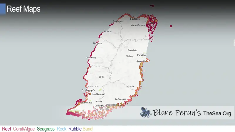
Grenada coral reef map
Reef gathers on the calm leeward coast of Grenada and around the low Grenadine islands to the north.
On the map, coral shading follows the sheltered west and south-west coasts of the main island, from the bays north of St George’s down past Grand Anse and Point Salines and along the indented south coast, where headlands and bays such as Prickly Bay and Woburn Bay create calm water. The windward (Atlantic) east coast, battered by the trade-wind swell, carries less mapped reef. To the north, beyond the submarine volcano Kick ’em Jenny, shading rings Carriacou, Petite Martinique and the scatter of small cays around them, where the sea is shallow and clear.
The reef outlines come from the UNEP-WCMC global warm-water coral reef dataset, compiled from satellite imagery and field surveys. Shading shows where reef structure has been mapped, not how much live coral it carries, and the map is a guide rather than a navigation chart. Shallow reef and coral heads are a genuine hazard to boats, particularly around Carriacou and the cays.
Grenada’s main reef and dive areas
Most diving is concentrated off the south-west coast, with a second hub around Carriacou.
- Molinere Bay (west coast, north of St George’s) — a sheltered bay with fringing reef and the Molinere Underwater Sculpture Park, suitable for both snorkellers and divers.
- Bianca C (off Grand Anse and St George’s) — the wreck of a large cruise liner lying in deep water, an advanced dive known for its scale, coral growth and passing eagle rays.
- South-west and south coast reefs — fringing and patch reefs off Point Salines and the south-coast bays, with a range of shallow and deeper dive sites.
- Carriacou (Grenadines) — reefs around the island and its satellite cays, including Sandy Island, with some of the healthiest coral and clearest water in the country.
- Petite Martinique — a small, steep island with fringing reef and a long boat-building and fishing tradition.
Grenada’s waters also hold a number of other wrecks, some sunk deliberately as dive sites, which add hard structure for coral and fish in areas with little natural reef.
The underwater sculpture park and the Bianca C
Art and history give Grenada two dive sites found nowhere else.
The Molinere Underwater Sculpture Park began in the mid-2000s with work by the sculptor Jason deCaires Taylor and is widely described as the world’s first underwater sculpture park. Life-size figures, including a ring of children holding hands, were cast in a pH-neutral marine cement and placed on sand in shallow, sheltered water. Over the years corals, sponges and algae have settled on them, and fish now shelter among the figures. The park was partly a conservation idea: by giving visitors a striking new site, it draws traffic away from fragile natural reefs and adds hard surface where coral larvae can settle. Later pieces by other artists have expanded the collection.
The Bianca C is an Italian cruise liner that caught fire in St George’s harbour in October 1961. Rescuers from the island helped bring passengers ashore, and the burning ship was later towed out of the harbour, where she sank. She now rests upright on sand in deep water off Grand Anse. Her size, the depth and the currents that often sweep the site make her a dive for experienced, properly trained divers. Over six decades she has been colonised by sponges, black coral and hard corals, and the open water around the wreck is known for eagle rays, barracuda and turtles.
Volcanic Grenada and its Grenadines
A steep volcanic island in the south, low reef-fringed islets in the north.
The main island of Grenada is volcanic in origin, with forested ridges and a steep, river-cut interior. As on other volcanic islands of the Lesser Antilles, its shores drop quickly into deep water and its reefs are mostly narrow fringing reefs, best developed where bays and headlands block the Atlantic swell. Rivers carry sediment and nutrients to the coast after heavy rain, which limits coral growth near some river mouths. Between Grenada and Carriacou lies Kick ’em Jenny, one of the most active submarine volcanoes in the Caribbean, and boats are advised to respect the exclusion zone around it when it shows signs of activity.
The Grenadine islands to the north are smaller and lower. Carriacou and Petite Martinique sit on a shallow bank shared with St Vincent’s Grenadines, and their coasts are lined with reef, seagrass and, in places, mangroves. The shallow water, small population and lack of large rivers make Carriacou’s reefs some of the clearest in the country. For the northern half of the same chain, see our St Vincent and the Grenadines coral reef maps.
Reef life around Grenada
Typical eastern Caribbean reef life, with wrecks and sculptures adding extra habitat.
Grenada’s reefs carry the corals and fish of the wider eastern Caribbean: brain, star and finger corals, sea fans and sea rods, and large barrel and tube sponges. Parrotfish, surgeonfish, angelfish, damselfish, grunts and snappers are common on the reefs, with moray eels and spiny lobster in the crevices. Hawksbill and green turtles feed on reefs and in seagrass, and southern stingrays and spotted eagle rays cross the sandy areas. The open-water dives, including the Bianca C, attract larger visitors such as barracuda and jacks. For a broader look at reef communities, see what animals and plants live in coral reefs.
Seagrass beds and mangrove-lined bays on Grenada’s south coast and on Carriacou are an important part of the system. They act as nurseries for juvenile fish, lobster and conch and help trap sediment before it reaches the coral.
Reefs, fisheries and protection
Grenada relies on its reefs for food, tourism and shoreline protection.
Fishing is part of daily life in Grenada, and on Carriacou and Petite Martinique the sea, sailing and traditional wooden boat-building are central to the community. Reef fish, lobster and conch support local livelihoods, while dive and snorkel tourism built around the reefs, wrecks and sculpture park brings in visitors. In a hurricane-prone region, reefs also act as natural breakwaters that take energy out of waves before they reach the shore.
Grenada has designated marine protected areas to manage these resources, including the Molinere–Beausejour MPA off the west coast and protected areas around Sandy Island and Oyster Bed on Carriacou, along with others in the south. These areas use zoning, moorings and fees to limit anchor damage and overfishing. The wider case for reef protection is set out on our coral reef conservation page.
Threats to Grenada’s reefs
Hurricanes, heat stress, disease, runoff and fishing pressure.
Grenada sits near the southern edge of the hurricane belt, but major storms still reach it. Hurricane Ivan struck the island hard in September 2004, and Hurricane Beryl made landfall on Carriacou in July 2024, devastating Carriacou and Petite Martinique and damaging shallow reefs and coastal habitats. Like the rest of the region, Grenada’s reefs are also exposed to marine heatwaves and coral bleaching, coral diseases including stony coral tissue loss disease, overfishing of reef fish and herbivores, and sediment and nutrient runoff from land clearing and coastal development. Seasonal Sargassum influxes have affected some shores.
The island’s MPAs, mooring programmes and coral restoration efforts help, but the long-term future of its reefs depends on managing local pressures while global warming is brought under control. For the regional picture, see causes of coral reef destruction in the Caribbean.
Related on TheSea
- Bermuda Coral Reef Maps
- Saint Kitts & Nevis Coral Reef Maps
- Turks Caicos Coral Reef Maps
- Montserrat Coral Reef Maps
- Cuba Coral Reef Maps
- British Virgin Islands (UK Virgin Islands) Coral Reef Maps
- US Virgin Islands Coral Reef Maps
- Barbados Coral Reef
- Bahamas Coral Reef
- Roatan Coral Reef
- Coral Reef Underwater Park Trail
- Caribbean Coral Reefs
Does Grenada have coral reefs?
Yes. Fringing reefs line the sheltered west and south coasts of the main island, and reefs surround Carriacou, Petite Martinique and the nearby cays. UNEP-WCMC maps roughly 59 km² of reef across the country.
Where is the best snorkelling in Grenada?
Molinere Bay and the underwater sculpture park are popular on calm days, along with reefs off the south-west coast. On Carriacou, Sandy Island and the surrounding cays have clear water and healthy reef.
What is the Grenada underwater sculpture park?
A collection of submerged sculptures in Molinere Bay, begun by Jason deCaires Taylor in the mid-2000s and widely described as the world’s first underwater sculpture park. The figures have become an artificial reef colonised by coral, sponges and fish.
How deep is the Bianca C wreck?
The Bianca C lies in deep water off Grand Anse, beyond normal recreational depths for much of the wreck, and currents are common. It is treated as an advanced dive and is best done with a local operator.
Is Grenada good for scuba diving?
Yes. Grenada combines fringing reefs, a large historic wreck and the sculpture park, while Carriacou adds quieter reefs and clear water, giving a wide range of dives for beginners and experienced divers.
What threatens Grenada’s coral reefs?
Hurricanes such as Ivan (2004) and Beryl (2024), marine heatwaves and bleaching, coral disease, overfishing, and sediment and nutrient runoff from land are the main threats.
- UNEP-WCMC, WorldFish Centre, WRI, TNC: Global distribution of warm-water coral reefs, v4.1 (2021)
- Government of Grenada, Fisheries Division: marine protected areas
- NOAA Coral Reef Information System: Caribbean reef ecology
Blane Perun has been exploring Earth’s oceans and marine life for over 25 years. Founder of TheSea.Org in 1999, underwater photographer, coral aquaculture pioneer, and explorer of 80+ countries.
About Blane Perun → More Caribbean Coral Reef Maps →