Venezuela Coral Reef Maps — Los Roques, Las Aves & Morrocoy
Venezuela’s coral reefs lie mostly offshore, around the islands and archipelagos that dot the southern Caribbean north of the mainland. By far the most important is Los Roques, an atoll-like archipelago of reefs, cays and turquoise lagoons about 150 km north of Caracas, protected as a national park since 1972. Smaller reef archipelagos lie at Las Aves and La Orchila, more reefs fringe Margarita and the eastern islands, and Morrocoy National Park protects coastal reefs, cays and mangroves on the mainland. Global mapping by UNEP-WCMC records roughly 350 km² of coral reef in Venezuela. The map below shows where they are.
Venezuela has one of the longest Caribbean coastlines in South America, but very little of its coral grows along the mainland shore. Rivers, upwelling and sediment make most of the coast unsuitable for large reefs. Instead, the country’s best reefs are found out at sea, on islands and banks bathed in clear oceanic water. This page explains where Venezuela’s reefs are, what makes Los Roques special, how to read the map and the pressures the reefs face.
Where are Venezuela’s coral reefs on the map?
The map shows a chain of offshore reef clusters strung along the southern Caribbean, with the broad ring of Los Roques as the dominant feature.
Los Roques lies north of Caracas. West of it are the two small reef archipelagos of Las Aves (Aves de Barlovento and Aves de Sotavento), and near Los Roques is La Orchila, a military island with fringing reefs. Further east, reefs surround La Blanquilla, Los Testigos, Los Frailes and parts of Margarita and Cubagua. On the mainland, Morrocoy National Park in Falcón state protects coastal reefs, cays and mangroves, and Mochima National Park near Puerto La Cruz has coral communities in sheltered bays.
This offshore pattern is typical of the southern Caribbean. Venezuela’s reefs share the same oceanic setting as the reefs of nearby Bonaire and Curaçao, the islands of the Leeward Antilles just to the west.
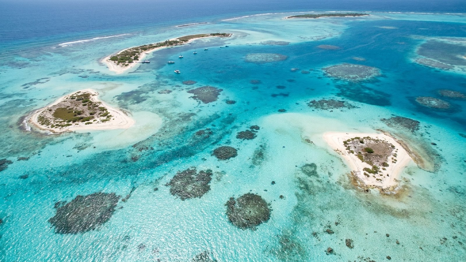
Los Roques: Venezuela’s best coral reef
Los Roques is one of the natural wonders of the southern Caribbean, an oval of reefs and cays enclosing a vast, shallow lagoon.
The archipelago is made up of hundreds of small cays and islets set within a large reef system. Barrier reefs line its eastern and southern edges, facing the open sea, while the sheltered lagoon inside holds patch reefs, seagrass beds, sand flats and mangroves. Its shape resembles an atoll, although it formed on a submerged continental platform rather than a sinking volcano. Declared a national park in 1972, Los Roques is one of the largest marine protected areas in the Caribbean, and in 1996 it was listed as a Ramsar wetland of international importance.
Its reefs are among the best developed and most diverse in Venezuela. Divers see brain, star, elkhorn and pillar corals, sea fans, sponges, schools of grunts and snappers, groupers, parrotfish, rays, nurse sharks and turtles. The clear, shallow lagoon is world famous among anglers for bonefishing, and the cays host colonies of seabirds and nesting beaches for green and hawksbill turtles. Gran Roque, the only island with a sizeable village, is the main entry point for visitors.
Las Aves, La Orchila and the eastern islands
Beyond Los Roques, Venezuela’s other offshore islands hold smaller but often well-preserved reefs.
The two Las Aves archipelagos lie west of Los Roques and are remote and lightly visited, reached mainly by yachts and fishing boats. Their reefs, cays and mangroves support seabird colonies and fish nurseries. La Orchila, a restricted military island, has fringing reefs that have seen little human use as a result.
In the east, the islands of La Blanquilla, Los Testigos and Los Frailes have rocky shores and coral communities washed by clear water, while Margarita and Cubagua have patchier reefs, influenced by the seasonal upwelling that makes these waters rich in sardines and other fish. Far to the north, the tiny Isla de Aves is an important nesting site for green turtles.
Morrocoy and Venezuela’s mainland reefs
Mainland reefs are easier to reach but more exposed to coastal pressures.
Morrocoy National Park, created in 1974 on the coast of Falcón state, protects a mosaic of small cays, fringing and patch reefs, mangrove channels and seagrass. It is one of Venezuela’s most popular beach destinations, especially for weekend visitors. In 1996 Morrocoy suffered a mass mortality event that killed much of its coral and many reef animals; the cause has been debated, and recovery has been slow and uneven.
Mochima National Park, further east between Puerto La Cruz and Cumaná, protects a deeply indented coast of bays and islands with coral communities. Here, as at Morrocoy, coral grows close to towns, tourism and runoff, and reefs show more signs of stress than those offshore.
Threats and protection for Venezuela’s coral reefs
Venezuela protects its key reefs in national parks, but management capacity, fishing pressure and warming seas are ongoing challenges.
Venezuela was an early leader in Caribbean marine conservation, creating Los Roques, Morrocoy and Mochima national parks in the 1970s. Together they protect a large share of the country’s coral. In practice, the level of management and monitoring has varied with the country’s wider economic and political situation, and pressures from fishing, tourism and coastal development have at times outpaced protection.
Like reefs across the Caribbean, Venezuela’s are affected by warming-driven bleaching and coral disease, including the spread of stony coral tissue loss disease in the region. Invasive lionfish arrived in the southern Caribbean around 2009 and prey on native reef fish. Overfishing of groupers, snappers, conch and lobster, pollution and sedimentation near the mainland add to the stress. The remote offshore reefs of Los Roques and Las Aves remain in better condition than the mainland reefs, protected largely by distance. Learn more in our coral reef conservation pages and causes of coral reef destruction in the Caribbean.
Visiting Venezuela’s reefs
Los Roques is the main destination for divers, snorkellers and anglers, reached by small plane or boat.
Most visitors reach Los Roques by small aircraft from the Caracas area to Gran Roque, where guesthouses (posadas) and dive operators are based. Visitors pay a national park fee, and parts of the park are zoned with restricted access to protect sensitive areas. The lagoon offers easy snorkelling and calm water, while the outer reefs suit divers. Conditions for travel change, so check current advice before planning a trip. Wherever you go, keep off the coral, use reef-safe sun protection and avoid buying conch, coral or turtle products.
Related on TheSea
Does Venezuela have coral reefs?
Yes. Venezuela’s reefs lie mainly offshore around Los Roques, Las Aves, La Orchila, Margarita and the eastern islands, with mainland reefs protected at Morrocoy and Mochima national parks.
What is Los Roques?
An atoll-like archipelago of hundreds of cays and islets surrounding a shallow lagoon, north of Caracas. A national park since 1972, it has Venezuela’s best-developed coral reefs.
Is Los Roques good for snorkelling and diving?
Yes. The clear, calm lagoon is excellent for snorkelling, and the outer barrier reefs offer diving with corals, sea fans, reef fish, rays and turtles.
How much coral reef does Venezuela have?
The UNEP-WCMC global dataset maps roughly 350 km² of coral reef in Venezuela, most of it around Los Roques and the other offshore islands.
Why are there few coral reefs along Venezuela’s mainland coast?
River runoff, sediment and seasonal upwelling of cool, nutrient-rich water limit reef growth along much of the coast. Clear oceanic water around the offshore islands is far better for coral.
What happened to the reefs at Morrocoy?
In 1996 Morrocoy National Park suffered a mass mortality event that killed much of its coral and many reef animals. The cause has been debated, and recovery has been slow.
What threatens Venezuela’s coral reefs?
Bleaching and coral disease, invasive lionfish, overfishing, tourism, pollution and sedimentation near the mainland, and uneven park management and monitoring.
- UNEP-WCMC, WorldFish Centre, WRI, TNC (2021). Global distribution of warm-water coral reefs, v4.1.
- Ramsar Sites Information Service: Archipiélago Los Roques.
- Published surveys of coral reefs in Los Roques and Morrocoy national parks.
Blane Perun has been exploring Earth’s oceans and marine life for over 25 years. Founder of TheSea.Org in 1999, underwater photographer, coral aquaculture pioneer, and explorer of 80+ countries.
About Blane Perun → More Coral Reef Maps →