Manatee Island Park — Daytona Beach’s River Island
Manatee Island Park is a free riverfront park on the Halifax River, part of the Intracoastal Waterway, at 351 N. Beach Street in downtown Daytona Beach. Since 2022 it has been part of the mile-long Riverfront Esplanade, reached through Manatee Plaza and open sunrise to sunset. Manatees live in the Halifax River year-round and are most visible in the cooler months, but sightings at the park are a matter of luck. For near-guaranteed winter viewing, drive about 45 minutes to Blue Spring State Park, where a record 932 manatees gathered in January 2024. Not to be confused with Fort Pierce’s manatee center.
This is a riverfront city park, not a wildlife refuge. You come for a walk along the river, a picnic or a festival, and if you’re lucky, a manatee surfaces in the river. Treat it as a bonus rather than a sure thing.
Manatee Island sits on the river side of Beach Street in historic downtown Daytona Beach, a short walk from the riverfront shops and across the Halifax River from the beach. Since 2022 it has been folded into the Riverfront Esplanade, a privately funded linear park that now runs along roughly a mile of the waterfront, and it pairs well with a Halifax River boat or paddle tour.
Manatee Island Park — at a glance
- Location: 351 N. Beach St., Daytona Beach, FL 32114 (within the Riverfront Esplanade)
- Water: Halifax River (Intracoastal Waterway)
- Hours: Sunrise to sunset
- Admission: Free
- Gateway: Manatee Plaza, with restroom, ranger station and Osprey Tower nearby
- Boating rule: Year-round slow-speed manatee zone through downtown Daytona
- Best manatee season: Cooler months; present year-round
Can you see manatees at Manatee Island Park?
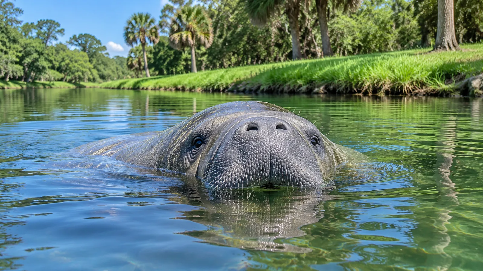
Sometimes. Manatees live in the Halifax River around Daytona Beach all year and are easiest to spot in the cooler months, when they move more slowly and stay in sheltered water. From the waterfront paths and overlooks, scan for the round, glassy “footprints” a manatee’s tail leaves on the surface, then watch for a snout. Manatees surface to breathe every few minutes and can rest underwater for around 15 minutes. Dolphins are often easier to spot in the river.
The name is a promise the river cannot always keep. Daytona’s downtown stretch of the Halifax is a working waterway with marinas, bridges and steady boat traffic, and manatees use it mostly as a travel corridor and a feeding area rather than as a place to gather in crowds. A visitor who comes once in July may see nothing but mullet jumping; a visitor who walks the riverfront every morning for a month will very likely see a few. The odds go up on calm, overcast or early-morning days when the water surface is flat and there is less glare, and they go down on windy afternoons when chop hides the small swirls that give a manatee away.
It helps to know what you are looking for. A manatee rarely shows more than the top of its head and the two nostrils at the tip of its snout. When it breathes, the nostril flaps open, you may hear a soft exhale, and the snout sinks again within a second or two. Larger signs are a broad, smooth patch of water where a heavy body has just pushed up from below, a line of bubbles drifting along the bottom, or the rounded edge of the paddle-shaped tail as an animal dives. On sunny days, polarised sunglasses cut the reflection and let you see grey shapes resting in shallower water near the bulkheads and docks.
Pick a calm morning, find a spot on the waterfront with the sun behind you and watch one patch of water for ten minutes. Most first manatee sightings come to people who stay put.
What is Manatee Island Park today?
For years Manatee Island Park was listed by the City of Daytona Beach as a stand-alone riverfront park on a small island in the Intracoastal Waterway, with a boardwalk, a fishing pier, picnic pavilions, a playground, restrooms and an amphitheater and stage that hosted annual seafood festivals. It was free, opened at sunrise and closed at sunset, and it shared the riverbank with the older Riverfront Park that lined Beach Street.
That riverbank has since been rebuilt. In 2019 the city commission voted unanimously to lease the mile-long riverfront property to the Brown Riverfront Esplanade Foundation, a nonprofit set up in 2017 by J. Hyatt Brown, the co-founder of the insurance firm Brown & Brown, and his wife Cici Brown. Under the lease the foundation renovates, runs and maintains the park for 50 years, while the city contributes a fixed annual maintenance payment of at least $800,000. Construction began in June 2020. The northern half, from Main Street to International Speedway Boulevard, opened at sunrise on June 4, 2022, and the southern half, from International Speedway Boulevard to Orange Avenue, celebrated its official opening in October 2023.
The finished Riverfront Esplanade covers about 22.5 acres along the Halifax River. City reports put the total project cost at about $35 million, and by late 2023 the foundation said it had invested more than $37 million, with an annual operating budget of around $2.2 million. The design team was led by Marquis Latimer + Halback. The original promise of a $15 million renovation plus a $3 million endowment grew considerably once the full design was drawn.
Manatee Island is now part of this park rather than a separate destination. The city describes Manatee Plaza, where a restroom building styled after the historic Kress building stands, as the gateway to Manatee Island. A ranger station, an Osprey Tower and a veterans monument framed by palms and colour-changing fountains sit in the same part of the park. Events listed for the Esplanade sometimes name “Manatee Island” as the host area, which is a useful clue when you search for festivals or markets.
What else is on the Riverfront Esplanade?
Because the island now sits inside a much larger park, a visit usually turns into a walk along the whole waterfront. The Sweetheart Trail runs the length of the Esplanade beside the river and has been resurfaced with a blue, cushioned running track that is easier on the knees than concrete. Swings for adults and children, benches angled toward the water and a broad event lawn shaded by large live oaks line the northern section, along with sculpted ponds whose fountains change colour at dusk.
Behind the News-Journal Center, the Halifax River Overlook was raised 10 feet, to about 15 feet above sea level, and is reached by an accessible spiral walkway lined with coquina boulders and bench swings. It is the best high vantage point on the downtown riverfront and the place to try first if you want to scan a wide stretch of water for surfacing manatees or dolphin fins. Further south, near International Speedway Boulevard and Orange Avenue, the newer section adds themed botanical gardens including coastal dune, palm, river and rose gardens, a large splash pad, a playground and a fenced dog park that requires an annual permit.
The Esplanade also honours the city’s best-known educator with the Dr. Mary McLeod Bethune Plaza at the corner of Mary McLeod Bethune Boulevard and Beach Street, where a bronze statue of her was unveiled in August 2022. Bethune founded the school for African American girls in Daytona Beach that grew into Bethune-Cookman University, and she later served as a national adviser to President Franklin D. Roosevelt. A tall bronze piece by Florida sculptor Paul Baliker, called Wild Florida, stacks twelve native animals on top of one another, among them a pelican, a spoonbill, an osprey, a Florida panther, a sea turtle, an alligator, a dolphin and a manatee.
Practical details are simple. The park opens at sunrise and closes at sunset, admission is free, and park security and local police monitor dozens of cameras along the waterfront. Opening can run a few minutes late because staff unlock the gates by hand; the city noted at the 2022 opening that 37 gates had to be opened every morning. Weekly markets, yoga sessions, holiday lights and family festivals keep the lawns busy, so mornings on weekdays are the quietest time for wildlife watching.
What is the Halifax River?
The Halifax River is not really a river in the usual sense. It is a narrow, tidal lagoon about 25 miles long that separates the Daytona Beach mainland from the barrier island on which the beach and the hotels stand. It begins at Tomoka Bay, where the Tomoka River, Bulow Creek and Halifax Creek meet beside Tomoka State Park, and flows south past Ormond Beach, Holly Hill, Daytona Beach, South Daytona and Port Orange before reaching the Atlantic through Ponce de Leon Inlet. Its drainage basin covers most of eastern Volusia County. Salt water enters through the inlet with every tide, so the water around Manatee Island is brackish to salty and rises and falls with the ocean.
The river forms part of the Atlantic Intracoastal Waterway, the protected route that lets boats travel along the East Coast without going out to sea. Before 1913 most Florida channels and canals were dug and maintained by private companies; one of them, organised in 1882, set out to link Jacksonville and Biscayne Bay through a chain of lagoons and cuts, and the Halifax became one link in that chain. Today the marked channel runs down the middle of the river past downtown Daytona, and the bridges that cross it are high enough for most traffic to pass beneath.
Four of those bridges are visible from the downtown waterfront. The Broadway Bridge, which carries U.S. 92, was replaced with a high span in 2001 and is decorated with mosaics of manatees, dolphins and other Florida wildlife, so it is worth a look from the Esplanade even when the water is empty. North of it are the Main Street Bridge, first opened in 1888, and the Seabreeze Bridge; to the south is the Veterans Memorial Bridge, whose old drawbridge was closed in 2016 and replaced with a tall fixed span.
How did the Halifax River get its name?
People have lived along this lagoon for about 7,000 years. The ancestors of the Timucua fished and gathered oysters here and left large shell mounds on both banks; most were later dug up for road fill, but a few, such as Ormond Mound and the Spruce Creek Mound Complex, are preserved. The Spanish captain Antonio de Prado explored the area around the inlet in 1569 and called it los Mosquitos for its clouds of biting insects, and Spanish maps labelled the lagoon the North Mosquito River. The present name dates from the British period between 1763 and 1784, when surveyors handing out land grants renamed it after George Montagu-Dunk, the 2nd Earl of Halifax and President of the Board of Trade, the same man for whom Halifax, Nova Scotia, is named.
Daytona itself grew on the west bank of the river. The ground under the historic downtown was once the Orange Grove Plantation, granted to Samuel Williams in 1787 and burned in 1835. In 1871 Mathias Day Jr. of Mansfield, Ohio, bought the tract and built a hotel, and although he soon lost title to the land, residents named the town Daytona after him when they incorporated in 1876. The railway arrived in 1886, Henry Flagler bought the line in 1889, and in 1926 Daytona, Daytona Beach, Kingston and Seabreeze merged into the present city. Beach Street, which runs beside Manatee Island, was the riverfront main street of that original mainland town.
When is the best time to see manatees in Daytona Beach?
In winter, roughly November to March. When the river and the ocean cool, manatees concentrate in warmer, sheltered water, and inland springs like Blue Spring fill up on cold mornings. In summer, manatees spread out along the river and coast and are harder to predict. More on why in manatee habitat.
Temperature drives everything. Florida manatees are near the northern edge of their range, and water below about 68°F (20°C) for long periods puts them at risk of cold stress, a condition that can damage skin, weaken the immune system and kill. As the Halifax cools in late autumn, many animals in the Daytona area travel west and south to the warm, steady water of Blue Spring on the St. Johns River, while others shelter in deeper, slower-cooling sections of the lagoon, canals and marina basins. On a mild winter day after a cold snap, animals that have stayed in the lagoon may surface more often in the shallows to warm up in the sun, which is one of the better times to watch from the downtown waterfront.
Spring and early summer bring a different kind of activity. As the water warms, manatees disperse widely to feed on seagrass and algae, travel up and down the coast, and gather in loose mating herds in which several males follow a single female for days or weeks. Calves are born after a pregnancy of about 12 to 14 months and stay with their mothers for up to two years, learning the routes to warm water and feeding grounds as they go. A mother and calf moving slowly along a seawall is one of the classic summer sightings in Volusia County waterways.
Why are boats told to slow down on the Halifax River?
Collisions with boats are the largest human-caused threat to Florida manatees. Manatees are slow, they spend much of their time near the surface, and in narrow, shallow waterways they often have nowhere to go when a fast hull approaches. Studies of carcasses found that 96 percent of adult Florida manatees carried scars from boat strikes, some from ten or more separate hits, and that boats caused about 53 percent of adult deaths between 1985 and 2017. The number of watercraft deaths reached a record 137 in 2019. Slower boats give both the animal and the operator time to react, which is why speed zones are the main protection tool.
In Volusia County those zones are set by state rule. Through downtown Daytona Beach, from a line 600 feet north of the Seabreeze Bridge south to a marked channel point, the entire river, including the main Intracoastal channel, is a year-round slow-speed zone. Along the Daytona Beach and Port Orange shorelines there is also a 300-foot slow-speed buffer from the shore. Up the Tomoka River and in Strickland, Thompson and Dodson creeks the rules are slow speed or idle speed year-round, and the Halifax River and several of those tributaries are designated as manatee sanctuary waters.
Volusia County also has its own Manatee Protection Plan. The first phase, covering habitat, education, research and boater interaction, was approved by the Florida Fish and Wildlife Conservation Commission in February 2001. The second phase, approved in October 2005, controls where new marinas and boat slips can be built by setting slip-to-shoreline ratios across the county, and its mitigation fees feed a Manatee Conservation Fund that pays for on-the-water speed-zone enforcement. For a visitor on a tour boat, kayak or paddleboard, the practical result is a calm, slow river through the city centre, which also makes it a safer place to paddle.
What other wildlife lives around Manatee Island?
Birds are the most reliable wildlife on this stretch of the river. Brown pelicans glide low over the water and plunge for fish, double-crested cormorants dry their wings on pilings, and American white ibis, snowy egrets, great egrets and great blue herons work the shallows and the edges of the bulkheads. Several kinds of gull, a variety of ducks in winter, and the occasional bald eagle, osprey or red-shouldered hawk overhead round out the list. Wood storks, a species that was listed under federal law for decades, also feed in the Halifax basin.
The river is also a good fishing water, and anglers along the waterfront and on the bridges target spotted seatrout, red drum, black drum, sheepshead, flounder, mangrove snapper and snook, with tarpon passing through in the warmer months. Bottlenose dolphins hunt along the channel edges throughout the year and are, for most visitors, a far more likely sighting than a manatee. Watch for the curved dorsal fin and the short, sharp exhale; dolphins usually surface several times in a row as they move, while a manatee shows only a snout and then disappears.
Where else can you see manatees near Daytona Beach?
Blue Spring State Park, Orange City (about 45 minutes): the best winter manatee site in Central Florida. The spring is the largest on the St. Johns River, holds a steady temperature of about 72 to 73°F and is a designated manatee refuge. A record 932 manatees were counted there in January 2024. Reservations are needed for entry.
Blue Spring has a long research history. Rangers and Save the Manatee Club researchers have recorded the life stories of individual manatees there since 1978, identifying each animal by the pattern of scars on its back and tail, and those records form one of the longest-running manatee databases anywhere. A boardwalk about a third of a mile long leads from the St. Johns River to the head of the spring, and all swimming, paddling and diving in the spring run stops during manatee season from mid-November through March. In the 2025–2026 season, Save the Manatee Club reported a high count of 859 manatees in early February, and the season formally closed on March 27, 2026.
Tomoka State Park, Ormond Beach: rivers and creeks where manatees and dolphins are seen; canoe and kayak rental and guided pontoon tours. The park sits where the Tomoka River enters the head of the Halifax, about three miles north of Ormond Beach on North Beach Street, and protects the site of the Timucua village of Nocoroco, which a Spanish explorer mentioned in 1569. Its creeks are slow-speed or idle-speed zones year-round.
Ponce Inlet: boat tours through protected wetlands and mangroves, with chances of dolphins, turtles and manatees. The 175-foot brick lighthouse at the inlet, first lit in 1887 and now a National Historic Landmark, makes a good half-day pairing with a tour.
Halifax River tours: narrated boat tours and paddleboard tours that often see dolphins and manatees.
How does Manatee Island Park compare with Florida’s big manatee sites?
| Site | Type | Manatee odds |
|---|---|---|
| Manatee Island Park, Daytona | Riverfront city park | Occasional |
| Blue Spring State Park | Natural spring refuge | Excellent in winter |
| Crystal River | Spring-fed bay | Excellent; in-water swims allowed |
| Apollo Beach | Power plant canal | Excellent in cold weather |
| Fort Pierce | Creek and lagoon center | Good in winter |
| Manatee Bay | Remote Keys bay | By boat or kayak |
The comparison comes down to warm water. The sites at the top of most lists, Blue Spring, Crystal River and the power-plant outflow at Apollo Beach, all offer manatees a reliable refuge from cold, so the animals gather there in large numbers every winter. A downtown lagoon park offers no such magnet, and Manatee Island will never match them for numbers. What it offers instead is a chance to meet manatees in the ordinary working waterways where they spend most of the year, with no reservation, no fee and a coffee shop across the street.
Many visitors combine both kinds of experience in one trip. A cold January morning at Blue Spring shows the population at its densest, with hundreds of animals packed into the spring run. An afternoon walk along the Daytona waterfront, or a slow tour down the Halifax toward Ponce Inlet, shows how those same animals live the rest of the year, grazing, travelling and resting among the docks and seawalls of a busy coastal city.
- Park address: 351 N. Beach St., Daytona Beach
- River: Halifax River / Intracoastal Waterway, about 25 miles long
- Riverfront Esplanade: about 22.5 acres, Main St. to Orange Ave.
- Blue Spring temperature: about 72–73°F year-round
- Blue Spring record: 932 manatees (Jan 2024)
Where is Manatee Island Park?
At 351 N. Beach Street in downtown Daytona Beach, on the Halifax River. It is now part of the Riverfront Esplanade, entered through Manatee Plaza.
Are there manatees at Manatee Island Park?
They live in the Halifax River year-round and are occasionally seen from the waterfront, especially in cooler months. Sightings are never guaranteed.
Is Manatee Island Park free?
Yes. The Riverfront Esplanade, including Manatee Island, is free and open from sunrise to sunset.
Where is the best place to see manatees near Daytona Beach?
Blue Spring State Park in Orange City, about 45 minutes away, in winter.
When is manatee season in Daytona Beach?
Roughly November to March, though manatees are present all year.
Can you fish near Manatee Island?
Fishing is popular on the Halifax River from banks, boats and bridges. Check current Esplanade rules for specific spots, and follow state saltwater licence rules.
Why is the river a slow-speed zone downtown?
State manatee rules make the Halifax River through downtown Daytona Beach a year-round slow-speed zone to cut boat strikes, the leading human cause of manatee deaths.
Is Manatee Island Park the same as the Fort Pierce manatee center?
No. Fort Pierce’s Manatee Observation and Education Center is roughly 160 miles south on the Indian River Lagoon.
- City of Daytona Beach / Sports Volusia. Manatee Island Park facility listing: address, hours, admission, amenities, seafood festivals.
- City of Daytona Beach news releases (2022, 2023). Riverfront Esplanade phase openings, Manatee Plaza and Manatee Island, Halifax River Overlook, Bethune Plaza, 37 gates, $37 million investment, $2.2 million operating budget.
- City of Daytona Beach CRA Annual Report 2023–2024. Riverfront Esplanade: 22.5 acres, $35 million project cost, $800,000 annual city contribution.
- The Jaxson / Modern Cities (2022). Daytona Beach’s Riverfront Esplanade: design team, construction start, 2019 lease.
- News Daytona Beach (2019). Browns reveal concepts for new riverfront park: 50-year lease, $15 million renovation pledge and $3 million endowment.
- Daytona Beach CVB. Riverfront Esplanade listing; Wild Florida sculpture by Paul Baliker; where to see manatees and dolphins.
- Florida Administrative Code 68C-22.012. Volusia County manatee protection zones: Halifax River and Tomoka River.
- Volusia County. Manatee Protection Plan, Phase I (2001) and Phase II (2005).
- Save the Manatee Club. Blue Spring manatee sighting updates, 2025–2026 season.
- AccuWeather / Smithsonian. Record 932 manatees at Blue Spring State Park, January 2024.
- US Fish and Wildlife Service. 2017 reclassification of the West Indian manatee to threatened.
- Wikipedia summaries: Halifax River; Daytona Beach, Florida; City Island (Daytona Beach); Blue Spring State Park; Tomoka State Park; West Indian manatee; Ponce de Leon Inlet Light.
Blane Perun has been exploring Earth’s oceans and marine life for over 25 years. Founder of TheSea.Org in 1999, underwater photographer, coral aquaculture pioneer, and explorer of 80+ countries.
About Blane Perun →