Java Sea — Indonesia’s Shallow Sea on the Drowned Sunda Shelf
The Java Sea is a shallow sea entirely within Indonesia, lying between Java to the south, Borneo to the north, Sumatra to the west and Sulawesi to the east. It covers about 320,000 km² (120,000 sq mi), stretches some 1,600 km east to west, and averages only 46 m deep. During the last ice age its entire floor was dry land, part of the Sunda Shelf that joined these islands to mainland Asia. Today it is one of the busiest and most heavily fished seas in Southeast Asia.
The Java Sea is a shallow, warm sea set entirely inside Indonesia, ringed by some of the most densely populated coastlines on Earth. It was dry land in the last ice age, was the scene of a major naval battle in the Second World War, and today feeds and connects millions of people. This guide covers its geography and depth, its monsoon currents, wildlife, islands, history, wrecks and threats.
Where is the Java Sea?
The Java Sea is enclosed by the Indonesian islands of Java, Borneo (Kalimantan), Sumatra and Sulawesi. To the north-west the Karimata and Bangka straits connect it to the South China Sea; the Sunda Strait between Java and Sumatra opens to the Indian Ocean; to the east it meets the Bali and Flores seas, and the Makassar Strait leads north. Jakarta, Indonesia’s capital, sits on its southern shore, along with Semarang and Surabaya.
How deep is the Java Sea?
The Java Sea is one of the shallowest seas of its size. It covers the southern part of the 1.8-million-km² Sunda Shelf, and its floor is almost uniformly flat, with an average depth of 46 m. Sonar surveys still reveal the drowned channels of ancient river systems that once drained the exposed shelf, a landscape scientists call Sundaland. When sea level was about 120 m lower during the last glacial maximum, people and animals could walk from mainland Asia to Java, Sumatra and Borneo; rising seas after about 15,000–7,000 years ago flooded the plain to form today’s sea.
Java Sea — key figures
| Measure | Value | Note |
|---|---|---|
| Surface area | ~320,000 km² | 120,000 sq mi |
| Length × width | ~1,600 × 380 km | |
| Average depth | 46 m | Flat, drowned shelf |
| Bordering country | 1 | Indonesia |
| Salinity | ~31–34 PSU | Freshened by rivers like the Barito and Musi |
| Surface temperature | ~27–30 °C | Little seasonal change |
| Currents | Reverse with the monsoon | West in the east monsoon, east in the west monsoon |
How does the monsoon affect the Java Sea?
Its circulation is driven by the Asian–Australian monsoon. From about December to March the west monsoon brings heavy rain and pushes surface water east; from about June to September the dry east monsoon reverses the flow. The seasonal swing in rainfall and river discharge changes salinity across the sea, and the shallow water mixes easily, keeping it warm and well oxygenated throughout.
What is the weather like on the Java Sea?
The Java Sea is hot and humid all year. Surface water stays around 27–30 °C, and air temperatures change little between seasons. What changes is wind and rain. During the west monsoon, from about December to March, frequent heavy downpours and squalls sweep across the sea, waves build in the shallow water, and ferries and small boats are sometimes held in port. During the east monsoon, from about June to September, the weather is drier and the sea generally calmer, which is the main season for island-hopping and diving.
Because the sea lies only a few degrees south of the equator, it is largely spared the full force of tropical cyclones, which rarely form so close to the equator. Even so, distant storms to the south and north can send swells and strong winds across it, and short, violent thunderstorms are common in the afternoons and evenings during the wet season.
Which islands lie in the Java Sea?
Although the open Java Sea is mostly flat and featureless, it is scattered with island groups. Just north of Jakarta lie the Thousand Islands (Kepulauan Seribu), a chain of more than a hundred small coral islands, some with resorts and villages and others protected in a marine national park. Off central Java, the 27 islands of Karimunjawa form another national park of reefs, seagrass and mangroves.
Farther east, Madura is a large, populous island separated from Java’s north-eastern coast by a narrow strait and linked to Surabaya by the Suramadu Bridge. North of it, the small island of Bawean is home to the Bawean deer, a rare species found nowhere else in the wild. The Kangean islands lie east of Madura. On the western edge of the sea, Bangka and Belitung, off Sumatra, have a long history of tin mining, and Belitung is known for granite boulders strewn along its white-sand beaches.
What lives in the Java Sea?
More than 3,000 marine species have been recorded in the area. Although the muddy central sea is mostly soft seabed, islands and banks support coral reefs, seagrass and mangroves.
- Coral reefs — Karimunjawa National Park, 27 islands off central Java, protects reefs, seagrass and mangroves; the Thousand Islands (Kepulauan Seribu) north of Jakarta have a marine national park. See Indonesia coral reef maps.
- Fisheries — small pelagic fish such as scads, mackerels and anchovies support huge purse-seine and lift-net fleets from Java’s north-coast ports.
- Turtles and mammals — hawksbill and green turtles nest on outer islands; Irrawaddy dolphins and finless porpoises live in coastal waters.
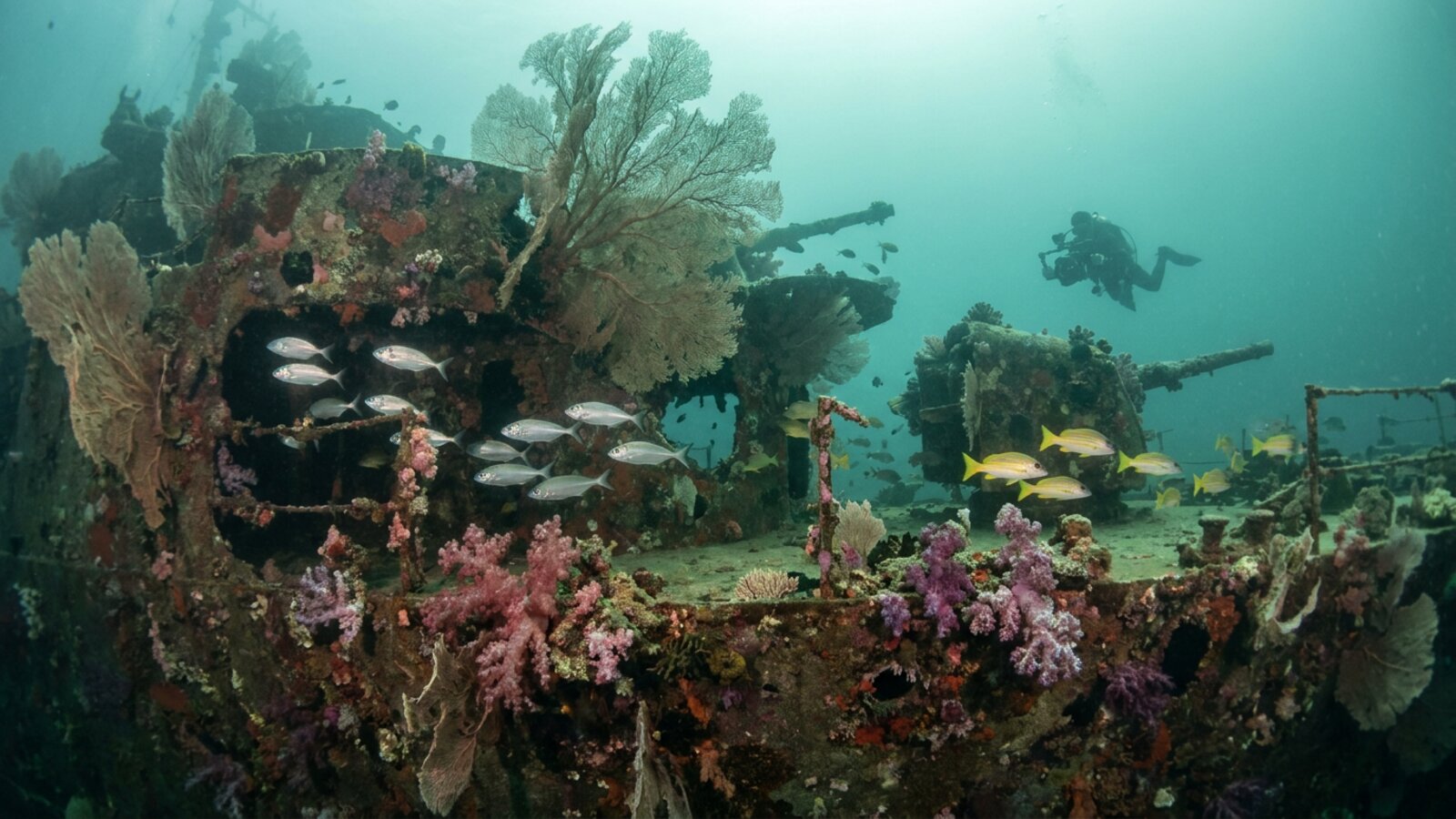
- Wreck reefs — sunken ships across the sea act as artificial reefs for fish and corals; see shipwrecks.
Why has the Java Sea been so important for trade?
For more than a thousand years the Java Sea has been a highway between the Indian Ocean and the South China Sea. Ships carrying spices, rice, textiles, ceramics and metals crossed it on the monsoon winds, linking the islands of the Indonesian archipelago with China, India and the Arab world. Ports on Java’s north coast, such as Banten, Demak, Gresik and Tuban, grew rich on that trade, and coastal towns became early centres of Islam in Java.
European powers followed. The Dutch East India Company made Batavia, today’s Jakarta, its Asian headquarters in the early 17th century, and the Java Sea became the heart of the Dutch colonial economy for more than three centuries. Today Jakarta’s Tanjung Priok is Indonesia’s busiest port, and Surabaya’s Tanjung Perak is another major hub. Ferries, cargo ships, tankers and traditional wooden boats still crisscross the sea, carrying people and goods between Java, Borneo, Sumatra and Sulawesi.
The sea also preserves older traces of that trade. In 1998 fishermen found a ninth-century Arab-style sewn-plank ship off Belitung, on the western edge of the Java Sea. Known as the Belitung shipwreck, it carried a large cargo of Chinese ceramics and gold and silver objects, and it is one of the most important finds for understanding early maritime trade between China and the Middle East.
What happened in the Battle of the Java Sea?
On 27 February 1942, an Allied fleet of Dutch, British, American and Australian warships under Dutch Rear Admiral Karel Doorman tried to stop a Japanese invasion force heading for Java. The Allies lost two Dutch cruisers, HNLMS De Ruyter and Java, and several destroyers, and Doorman was killed; follow-up actions in the following days sank HMS Exeter, USS Houston and HMAS Perth nearby. More than 2,000 Allied sailors died. In 2016 divers discovered that the wrecks of several of these ships had largely vanished from the seabed, illegally salvaged for scrap metal, prompting international outrage because they are war graves.
Can you dive the Java Sea?
Yes, though it is not Indonesia’s most famous dive region. The open sea is shallow and often murky, because rivers carry large loads of sediment off Java, Borneo and Sumatra and the monsoon stirs up the muddy bottom. The best diving is around the offshore island groups. Karimunjawa and the outer Thousand Islands have fringing reefs, seagrass beds and reasonable visibility in the drier months, roughly from about May to October, and reef fish, turtles and occasional reef sharks can be seen.
The sea’s many shipwrecks, from trading vessels to warships, attract technical divers, but the major Second World War wrecks lie deep in open water, are protected as war graves and have been badly damaged by illegal salvage. For clearer water and richer reefs, most divers head east to the Coral Triangle waters beyond the Java Sea; see the Indonesia coral reef maps.
Who fishes the Java Sea?
Fishing is a way of life along the Java Sea. Villages and ports on Java’s north coast, such as Pekalongan, Tegal and Rembang, as well as Madura and the coasts of Borneo and Sumatra, send out fleets ranging from small outrigger canoes to large purse-seiners. Many boats work at night, using bright lights to draw schools of small fish and squid to the surface, and fixed or floating lift-net platforms known as bagan are a common sight close to shore.
The catch is dominated by small pelagic fish, which are sold fresh, salted, dried or turned into fish paste and crackers, and it is a major source of protein for tens of millions of people. Because so many boats chase the same stocks in a small, shallow sea, scientists have repeatedly warned that catches per boat have fallen and that larger, slower-growing fish have become scarce. Indonesia has introduced fishing zones, licensing and catch rules to manage the pressure, but enforcement across thousands of small vessels is difficult.
Coastal communities face other changes too. Mangroves along much of Java’s north coast have been cleared for fish and shrimp ponds, leaving shorelines exposed to erosion and flooding, and several projects are now replanting mangroves to rebuild that natural buffer.
What threatens the Java Sea?
Heavy fishing pressure has depleted many stocks, and destructive practices such as blast fishing have damaged reefs. Rapid coastal development, pollution and plastic from Java’s densely populated north coast, sediment from deforested river catchments, and oil and gas activity all affect water quality. Jakarta itself is sinking by several centimetres a year in places because of groundwater extraction, making it highly vulnerable to sea-level rise and floods from the Java Sea — one reason Indonesia is building a new capital, Nusantara, on Borneo.
- The Java Sea is a 320,000-km² sea entirely within Indonesia.
- It averages only 46 m deep and was dry land in the ice age.
- The monsoon reverses its currents each year.
- The 1942 Battle of the Java Sea left war-grave wrecks, many since illegally salvaged.
- Overfishing, pollution and a sinking Jakarta are key issues.
Where is the Java Sea?
It lies within Indonesia, between Java, Borneo, Sumatra and Sulawesi, connected to the South China Sea in the north-west.
How deep is the Java Sea?
It is very shallow, averaging only 46 m, because it covers part of the drowned Sunda Shelf.
How big is the Java Sea?
About 320,000 km² (120,000 sq mi), roughly 1,600 km long and 380 km wide.
Which countries border the Java Sea?
Only Indonesia.
Was the Java Sea once dry land?
Yes. During the last ice age, when sea level was about 120 m lower, its floor was part of Sundaland, a land bridge linking Java, Sumatra and Borneo to mainland Asia.
What was the Battle of the Java Sea?
A February 1942 naval battle in which an Allied fleet failed to stop the Japanese invasion of Java; several Allied warships and more than 2,000 sailors were lost.
Is the Java Sea good for diving?
Parts are, especially Karimunjawa and the outer Thousand Islands, which have coral reefs and wrecks, though visibility is lower than in eastern Indonesia.
Blane Perun has been exploring Earth’s oceans and marine life for over 25 years. Founder of TheSea.Org in 1999, underwater photographer, coral aquaculture pioneer, and explorer of 80+ countries.
About Blane Perun → More on Seas →