Yellow Sea — Why It Is Yellow, How Deep It Is, and Why Its Tidal Flats Matter
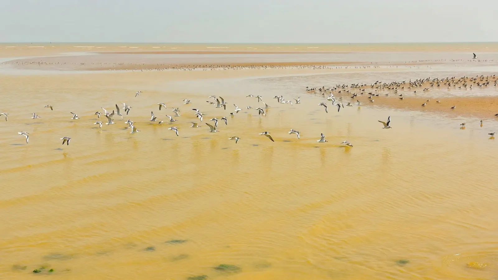
The Yellow Sea is a shallow marginal sea of the western Pacific between mainland China and the Korean Peninsula, forming the northern part of the wider East China Sea. It covers roughly 380,000 km² (about 150,000 sq mi) not counting its inner gulf, the Bohai Sea, averages only about 44 m deep and reaches about 152 m at its deepest. It is named for the golden-yellow silt carried in by the Yellow River (Huang He) and other rivers. Its very large tides — several metres along the Korean coast — expose some of the most extensive tidal flats on Earth, a vital refuelling stop for millions of migrating shorebirds.
The Yellow Sea is one of the most heavily used seas on Earth. Hundreds of millions of people live in the river basins that drain into it, its ports rank among the busiest in the world, and its fisheries and shellfish farms feed much of East Asia. Yet it is also a remarkably young and fragile sea: a flooded plain that was dry land at the end of the last ice age, shallow enough that its water warms, cools and mixes quickly, and lined with mudflats whose value for wildlife has only been widely recognised in recent decades.
Where is the Yellow Sea?
Between China’s Shandong and Jiangsu coasts to the west and the Korean Peninsula to the east.
The Yellow Sea stretches roughly 900–1,000 km from north to south and up to about 700 km across. Its innermost north-western arm is the Bohai Sea, almost enclosed by China’s Liaodong and Shandong peninsulas, and Korea Bay lies in the north-east between China’s Liaoning province and North Korea. To the south it merges into the East China Sea along a line usually drawn from near the mouth of the Yangtze River to Jeju Island off southern Korea.
Major cities and ports on its shores include Qingdao, Dalian, Tianjin (on the Bohai), Yantai and Lianyungang in China, Incheon and Gunsan in South Korea, and Nampo, the port of Pyongyang, in North Korea. Shipping lanes across the sea connect some of the busiest container ports in the world.
Why is the Yellow Sea yellow?
Because rivers pour vast amounts of fine yellow silt into it — the name is literal.
The Yellow River drains the Loess Plateau of northern China, a region of deep, wind-blown, yellowish silt that erodes easily. Historically the river carried one of the heaviest sediment loads of any river in the world, and that silt, together with sediment from other rivers, tints the coastal waters golden-yellow to brown, especially after summer floods. Dams, reservoirs and soil-conservation work have greatly reduced the river’s sediment delivery since the mid-20th century, but the coastal water is still noticeably turbid. In spring, dust storms from the Asian interior also drop yellow dust over the sea.
The Yellow River has not always emptied into the same place. For several centuries before 1855 its mouth lay on the Jiangsu coast of the Yellow Sea proper; a major course change that year shifted it north into the Bohai Sea, where it still enters today. The old delta on the Jiangsu coast has been eroding ever since. The Yellow Sea is one of four seas named for colours, alongside the Black, Red and White seas.
How deep is the Yellow Sea?
Very shallow: about 44 m on average and roughly 152 m at its deepest — it is a drowned piece of continental shelf.
During the last ice age, global sea level was around 120 m lower than today, and the entire floor of the Yellow Sea was dry land — a broad plain crossed by rivers flowing toward the deeper water of the East China Sea. As the ice sheets melted, rising seas flooded the plain over thousands of years. The result is a sea with a gently sloping, sediment-covered floor. Its deepest water lies in a trough toward the south-east, closer to Korea.
Because it is so shallow, the Yellow Sea has strong seasons. In winter, cold northerly monsoon winds chill and mix the water from top to bottom, and parts of the Bohai Sea and Korea Bay can freeze. In summer the surface warms strongly while a pool of cold bottom water left over from winter — known as the Yellow Sea Cold Water Mass — persists in the central basin beneath it.
Why are the Yellow Sea tides so big?
The broad, shallow basin and the shape of its coastline amplify the tide, especially on the Korean side.
Tides in the Yellow Sea behave like water sloshing in a large, shallow tray. The tidal wave entering from the south is steered around the basin, and along the west coast of Korea it piles up to produce ranges of several metres at spring tides. Incheon, Seoul’s port, has one of the largest tidal ranges in Asia, and its harbour relies on lock gates so ships can operate at low tide.
The tides also produce famous local spectacles. In the narrow Myeongnyang Strait off south-western Korea, tidal currents run fast enough to have shaped naval history. Near Jindo Island, unusually low spring tides expose a natural causeway of sand and shell to the neighbouring island of Modo for a short time, an event celebrated each year as the Jindo Sea-Parting Festival.
The Yellow Sea tidal flats and migratory birds
The huge tides expose vast mudflats that are the single most important refuelling stop on the East Asian–Australasian Flyway.
At low tide, enormous stretches of mud and sand are exposed along both the Chinese and Korean coasts. These flats are packed with worms, clams, snails and crabs, and they are where millions of shorebirds stop to feed on their journeys between breeding grounds in Siberia and Alaska and wintering grounds in South-East Asia, Australia and New Zealand. For many species there is no alternative stopover of comparable size.
Birds that depend on the Yellow Sea include the great knot, the bar-tailed godwit — famous for some of the longest non-stop flights of any bird — the Far Eastern curlew and the Critically Endangered spoon-billed sandpiper. UNESCO recognised the importance of the region by inscribing China’s Migratory Bird Sanctuaries along the Coast of the Yellow Sea–Bohai Gulf in 2019 and Korea’s Getbol tidal flats in 2021 as World Heritage Sites.
What else lives in the Yellow Sea?
A productive shelf sea that supports large fisheries, marine mammals and some spectacular jellyfish blooms.
Fish and shellfish. Croakers, hairtail, anchovy, mackerel, flatfish, prawns and squid have long supported major fisheries, and the coastal waters host extensive farms of shellfish, kelp and laver seaweed. Many fish stocks migrate seasonally, wintering in deeper southern water and moving north to spawn and feed in spring and summer.
Marine mammals. Spotted seals breed on winter sea ice in the Bohai Sea and are seen around Korea’s Baengnyeong Island in summer. Finless porpoises live in the shallow coastal waters.
Jellyfish. Nomura’s jellyfish, one of the largest jellyfish in the world, with a bell that can approach 2 m across, blooms in the Yellow and East China seas in some years and drifts into Japanese waters, clogging fishing nets. See our page on giant jellyfish for another heavyweight.
What threatens the Yellow Sea?
Land reclamation, overfishing and nutrient pollution have changed the sea profoundly in a few decades.
Large areas of tidal flat along the Chinese and Korean coasts were reclaimed in the late 20th and early 21st centuries for ports, industry, farmland and aquaculture ponds, and studies have estimated that a large share of the region’s tidal flats has been lost over the past half-century. South Korea’s Saemangeum seawall, completed in 2006, closed off a major estuary that had been one of the most important shorebird sites in the country.
Fishing pressure has depleted many traditional stocks. Fertiliser and sewage from the river basins fuel harmful algal blooms, low-oxygen zones and huge “green tides” of Ulva seaweed, such as the bloom that had to be cleared from Qingdao’s coast before the 2008 Olympic sailing events. In recent years, reclamation of natural tidal flats has been tightly restricted in both China and South Korea, and the World Heritage listings have added protection, but restoring a heavily used sea will take sustained regional cooperation.
Why is it called the Yellow Sea?
Because fine yellow silt washed in by the Yellow River and other rivers, much of it eroded from China’s Loess Plateau, tints its coastal waters golden-yellow to brown.
How deep is the Yellow Sea?
It averages about 44 m deep and reaches about 152 m at its deepest. During the last ice age, when sea level was much lower, it was dry land.
Which countries border the Yellow Sea?
China, North Korea and South Korea.
Is the Yellow Sea part of the Pacific Ocean?
Yes. It is a marginal sea of the western Pacific and is usually treated as the northern part of the East China Sea.
Is the Yellow Sea actually yellow?
Near the coasts and river mouths it often is, especially after floods. Further offshore, where the silt settles out, the water looks green or blue like other shelf seas.
What is the Bohai Sea?
The innermost north-western gulf of the Yellow Sea, enclosed by Chinese coastline, into which the Yellow River now flows.
Why are the Yellow Sea tidal flats important?
They are the most important stopover on the East Asian–Australasian Flyway, where millions of migrating shorebirds, including the Critically Endangered spoon-billed sandpiper, refuel on worms and shellfish.
- UNESCO World Heritage Centre: Migratory Bird Sanctuaries along the Coast of Yellow Sea–Bohai Gulf of China (2019); Getbol, Korean Tidal Flats (2021)
- East Asian–Australasian Flyway Partnership: Yellow Sea shorebird habitat
- Encyclopedic summaries: Yellow Sea; Bohai Sea; Yellow River
Blane Perun has been exploring Earth’s oceans and marine life for over 25 years. Founder of TheSea.Org in 1999, underwater photographer, coral aquaculture pioneer, and explorer of 80+ countries.
About Blane Perun → More on Seas →