How Deep Is Zhemchug Canyon? — Rim, Walls and Floor of the Bering Sea’s Giant
Zhemchug Canyon has a vertical relief of about 2,600 m (8,530 ft), the height of its walls from the rim at the edge of the Bering Sea shelf down to its floor. That is roughly 40 percent deeper than Arizona’s Grand Canyon (about 1,857 m). Because the canyon begins underwater, its floor lies even deeper below the sea surface: the main channel drops from about 100 to 150 m at the shelf edge to more than 3,000 m, and the traced channel ends near 3,800 m in the Aleutian Basin. The deepest a person has gone into it is about 536 m (1,757 ft), in a small submarine in 2007.
How deep is Zhemchug Canyon?
The short answer is that Zhemchug Canyon is about 2,600 metres, or 8,530 feet, deep. That figure is its vertical relief: the difference in height between the canyon’s rim, where it cuts into the edge of the Bering Sea continental shelf, and its floor, where it opens out into the deep Aleutian Basin. It is the figure used by the US Geological Survey geologists who compared the world’s largest submarine canyons, and it is the basis for the common claim that Zhemchug is deeper than the Grand Canyon. The Grand Canyon in Arizona reaches about 1,857 metres (6,093 ft) from rim to river, so Zhemchug is roughly 40 percent deeper.
There is a second way to answer the question, which is to ask how far below the sea surface the canyon floor lies. Because the whole canyon is underwater, its rim is already well below sea level. The Bering Sea shelf edge, where the canyon begins, lies roughly 100 to 170 metres deep. From there the canyon floor descends along its length until it reaches the basin floor more than 3,000 metres down. A 2018 NOAA proposal to the international committee that names undersea features placed the canyon’s name point at a depth of about 3,016 metres and traced its channel down to about 3,811 metres near the 180th meridian. So, depending on what is being measured, Zhemchug is “2,600 metres deep” or “nearly 3,800 metres deep”, and both statements can be correct.
Why do sources give different depths?
Confusion about canyon depths comes from the difference between relief and depth below the surface, and also from how a canyon’s ends are defined. On land, the depth of a canyon is usually measured from the rim to the river at the bottom. Under the sea there is no river, and a submarine canyon gets deeper continuously from its head to its mouth, so its relief changes from place to place along its length. Researchers often quote the maximum relief, the greatest height of the canyon walls at any cross-section, which for Zhemchug is about 2,600 metres.
NOAA’s 2018 description of the whole canyon system, from its shallowest feeder channels on the shelf at about 64 metres to its deepest traced point at about 3,811 metres, gave a total relief of about 3,750 metres. That is a different measurement: it describes the full drop along the channel rather than the height of the walls at one spot. Popular articles sometimes add to the confusion by quoting depth in feet or metres without saying which measure they mean. For comparisons with the Grand Canyon, wall height is the fairer measure, and on that basis the usual figure of about 2,600 metres stands.
How deep is the Bering Sea around the canyon?
To picture the canyon’s depth, it helps to see the sea it cuts into. The Bering Sea has two very different halves. Its north-eastern half is the broad continental shelf, mostly less than 200 metres deep and in large parts less than 100 metres, which in winter is covered by sea ice that forms in the north and drifts south. Its south-western half is the Aleutian Basin, a deep plain generally between about 3,500 and 4,000 metres deep, bounded to the south by the Aleutian Islands arc. Between the two runs the continental slope, the steep step down from shelf to basin, and it is into this step that Zhemchug and its neighbouring canyons are cut.
Standing on the shelf above the canyon head, a submarine would be in water little deeper than a tall office tower. Moving west across the shelf break, the floor would fall away beneath it, first gradually and then steeply, until it was more than three kilometres down in the basin. Zhemchug Canyon is essentially a giant notch in that slope, reaching back into the shelf and funnelling water, sediment and nutrients between the two worlds.
How was the depth of Zhemchug Canyon measured?
Everything we know about the shape of Zhemchug Canyon comes from echo sounding. A ship sends a pulse of sound to the seafloor and times the echo; knowing the speed of sound in seawater, roughly 1,500 metres per second and varying with temperature, salinity and pressure, the depth can be calculated. Early surveys used single-beam echo sounders, which measure depth directly beneath the ship along its track. The first chart of the feature came from such a survey by the US Coast and Geodetic Survey ship Pioneer in 1953, and Soviet fishery vessels, including one named Zhemchug, surveyed the area in 1958.
In the 1960s, David Scholl and colleagues at the US Geological Survey combined echo soundings with seismic reflection profiles, which use sound to image layers of sediment and rock beneath the seabed. Their 1970 paper in Marine Geology mapped the large Bering Sea canyons and estimated that Zhemchug had removed about 8,500 cubic kilometres of sediment, making it potentially the largest canyon in the world. Later studies used multibeam echo sounders, which sweep a wide fan of beams across the seafloor and produce detailed three-dimensional maps. William Normark and Paul Carlson of the USGS, comparing giant canyons worldwide in 2003, gave Zhemchug a relief of about 2,600 metres, a volume of about 5,800 km³ and a drainage area of about 11,350 km². The difference between the two volume estimates reflects different methods and definitions of the canyon’s boundaries.
How steep are the walls of Zhemchug Canyon?
Submarine canyons are usually less dramatic in profile than their land equivalents, because their walls are mainly soft sediment and the canyons are very wide. Zhemchug is a broad valley rather than a slot; its main branches are tens of kilometres across at the shelf edge. Its walls descend steeply relative to the surrounding seafloor but are not sheer cliffs over their whole height. The contrast with the shelf is striking: the Bering Sea shelf above the canyon is extraordinarily flat, falling by only about three or four inches per mile, according to the writer Dan O’Neill, quoted in accounts of the 2007 expedition. At the shelf break the seafloor tips over into the canyon and the continental slope, and the depth increases by thousands of metres over a relatively short distance.
The overall gradient of the canyon floor along its length is gentle. NOAA’s 2018 proposal listed an average slope of about 0.3 degrees along the traced channel, because the channel runs for hundreds of kilometres. The steepest parts are the canyon walls and the upper slope, where sediment slides and flows have cut deep gullies and scarps.
How deep have humans gone into Zhemchug Canyon?
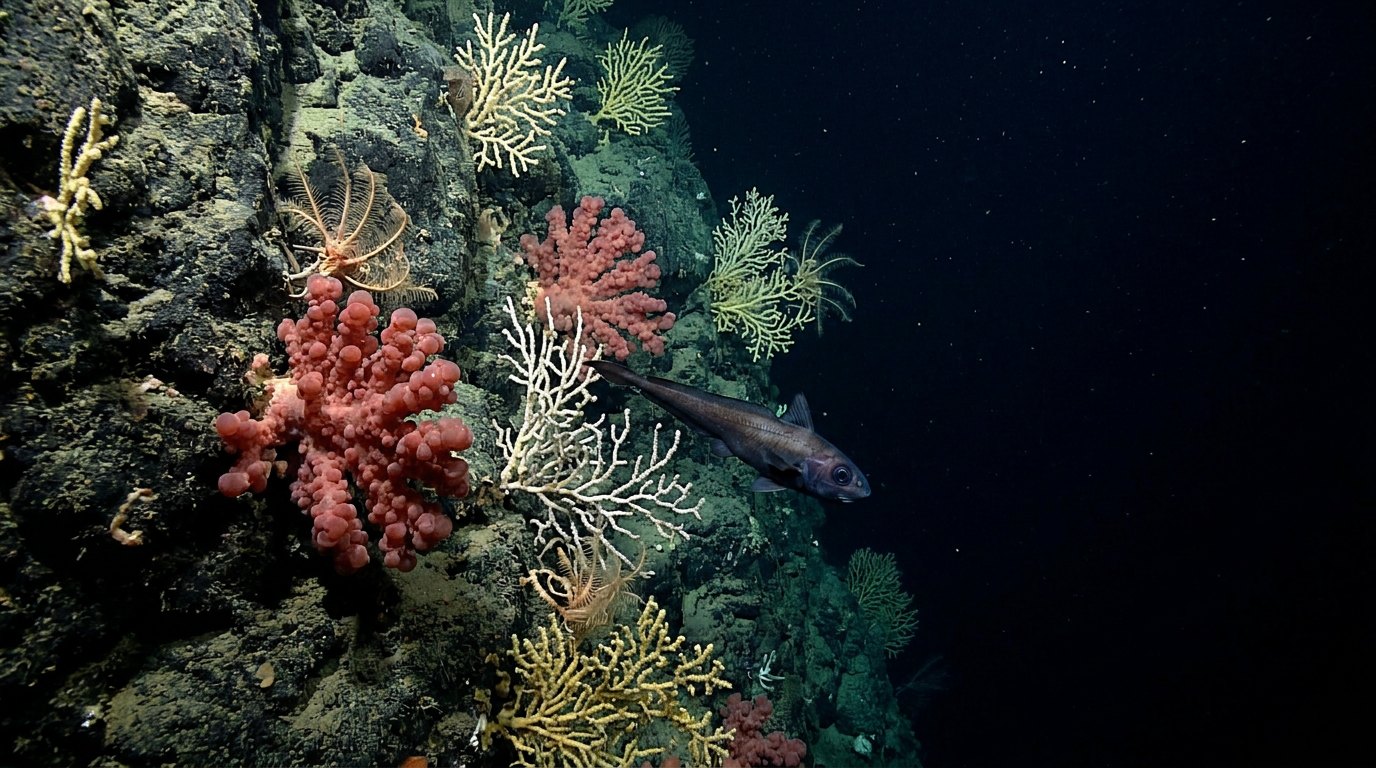
Only a handful of people have ever been inside Zhemchug Canyon. In August 2007, during a Greenpeace expedition aboard the ship Esperanza, Juneau marine ecologist Michelle Ridgway descended alone into the canyon in a small one-person submersible about eight feet long, with a titanium hull and an acrylic dome. Dall’s porpoises followed her down to about 90 metres. She reached a ledge at about 536 metres (1,757 ft), roughly a fifth of the canyon’s depth, where she saw corals, sponges, fish and crabs in shades from pale gold to brick red, including a small golden king crab sheltering in an orange sponge. She also reported dense zooplankton at every depth she passed through, rather than only near the surface.
Ridgway and her colleagues hoped to return with a vehicle rated to about 1,300 metres and with a remotely operated vehicle capable of reaching the canyon floor. The deepest parts of Zhemchug have been sampled mainly by remote means: trawls, grabs, drop cameras and towed camera sleds deployed from research ships. In 2014, NOAA’s Alaska Fisheries Science Center ran a large camera survey of the eastern Bering Sea slope and outer shelf, including the canyons, taking more than 250,000 photographs along 250 transects.
What are conditions like at different depths?
Like all deep water, the inside of Zhemchug Canyon changes dramatically with depth. Near the rim, at about 100 to 200 metres, there is still some daylight, and the water is strongly influenced by the seasons: cold, nutrient-rich, and in winter close to freezing on the shelf. Below about 200 metres, sunlight fades into the twilight or mesopelagic zone, where there is too little light for photosynthesis. Below about 1,000 metres, the canyon is in the midnight or bathypelagic zone, permanently dark apart from the glow of bioluminescent animals.
Pressure rises by about one atmosphere for every 10 metres of depth. At the 536-metre ledge Ridgway reached, the pressure was more than 50 times that at the surface. At 2,600 metres it is roughly 260 times surface pressure, and at the canyon’s deepest traced point, near 3,800 metres, about 380 times. Deep water in the Bering Sea basin is cold, generally around 2 to 3 °C, and relatively low in oxygen at mid-depths, where an oxygen minimum layer is a typical feature of the North Pacific. These conditions shape which animals can live on the canyon walls and floor.
What lives at different depths in the canyon?
The upper canyon and surrounding shelf break are among the most productive waters in the Bering Sea. Here, nutrient-rich water from the deep basin is mixed upward along the shelf edge, supporting large blooms of phytoplankton and the zooplankton, fish and squid that feed on them. Walleye pollock, Pacific cod, rockfish and flatfish are abundant, along with snow crab, Tanner crab and king crab. Northern fur seals from the Pribilof Islands, whales, dolphins and porpoises feed over the canyon, and seabirds, including the endangered short-tailed albatross, gather to forage on the surface.
Deeper on the canyon walls, scientists have recorded habitat-forming invertebrates that grow on any hard surface: bubblegum coral, bamboo coral, sea whips, soft corals and glass sponges. Surveys in 2007 found gorgonian corals at densities of up to about 0.13 colonies per square metre in Zhemchug and about 0.73 in neighbouring Pribilof Canyon. Because rocky substrate is scarce on the sediment-covered Bering Sea slope, corals are patchy, and the 2014 NOAA camera survey found the highest densities in Pribilof Canyon. At greater depths, the canyon floor is home to the slow-moving, sparse fauna typical of the deep North Pacific: sea cucumbers, brittle stars, grenadiers and other deep-sea fishes, and animals that feed on organic matter sinking from the productive water far above.
How does Zhemchug’s depth compare with other canyons?
Zhemchug is one of a family of giant submarine canyons. Its relief of about 2,600 metres is greater than that of most canyons on continental margins, including Monterey Canyon off California, whose walls rise as much as about 1.6 km (1 mile) in places and which runs about 153 km to depths of some 3,600 metres at its mouth, but which holds a far smaller volume. Bering Canyon, its neighbour to the south, is longer, about 400 km, but has a smaller volume. The Great Bahama Canyon, cut between the Bahamas carbonate banks, is often cited as having the tallest walls of any canyon, up to about 4 to 5 km, because it is incised between platforms that rise almost vertically from the deep sea floor. On land, the Grand Canyon reaches about 1,857 metres, and some Himalayan gorges, such as the Yarlung Tsangpo in Tibet, are deeper still when measured from the surrounding peaks, but no land canyon matches Zhemchug’s volume.
| Canyon | Approximate depth or relief | Setting |
|---|---|---|
| Zhemchug Canyon | About 2,600 m relief | Bering Sea shelf edge |
| Bering Canyon | Floor reaches about 3,200 m | Bering Sea, longest at about 400 km |
| Monterey Canyon | Walls up to about 1.6 km | Off central California |
| Great Bahama Canyon | Walls up to about 4 to 5 km | Between the Bahama Banks |
| Grand Canyon | About 1,857 m | Arizona, carved by the Colorado River |
Why does the depth of Zhemchug Canyon matter?
Depth is more than a record. Large submarine canyons like Zhemchug act as conduits that move sediment, organic matter and water between the continental shelf and the deep sea, and they create a wide range of habitats over a short distance, from sunlit shelf edge to cold, dark abyss. Their steep, varied walls give corals and sponges places to settle in an otherwise muddy landscape, and the currents they funnel support some of the richest fisheries in North America. Understanding how deep the canyon is, and how its depth changes along its length, helps scientists model those currents and predict where vulnerable habitats lie.
How deep is Zhemchug Canyon?
It has about 2,600 m (8,530 ft) of vertical relief from rim to floor.
How far below the sea surface is the canyon floor?
More than 3,000 m in its main channel, and about 3,800 m at its deepest traced point.
Is Zhemchug Canyon deeper than the Grand Canyon?
Yes. Its walls are about 2,600 m high versus about 1,857 m for the Grand Canyon.
Has anyone been to the bottom of Zhemchug Canyon?
No. The deepest human dive, in 2007, reached about 536 m.
How was Zhemchug Canyon’s depth measured?
By ship-based echo sounders and seismic surveys from the 1950s onward.
What lives deep in Zhemchug Canyon?
Corals, glass sponges, crabs, rockfish and deep-sea fishes, with whales and seabirds feeding above.
- Normark, W.R. & Carlson, P.R. (2003). Giant submarine canyons: Is size any clue to their importance in the rock record? GSA Special Paper 370.
- Scholl, D.W. et al. (1970). The structure and origin of the large submarine canyons of the Bering Sea. Marine Geology 8: 187–210.
- Zimmermann, M. & Prescott, M. (2018). Zhemchug Canyon proposal to IHO-IOC SCUFN. NOAA Alaska Fisheries Science Center.
- Rozell, N. (2007). A visit to one of Earth’s great canyons. Alaska Science Forum, University of Alaska Fairbanks.
- Miller, R.J. et al. (2012). Structure-forming corals and sponges in the Pribilof and Zhemchug canyons. PLoS ONE.
- Rooper, C.N. et al. (2017). Corals, canyons and conservation. Frontiers in Marine Science 4: 142.
Blane Perun has been exploring Earth’s oceans and marine life for over 25 years. Founder of TheSea.Org in 1999, underwater photographer, coral aquaculture pioneer, and explorer of 80+ countries.
About Blane Perun →