Zhemchug Canyon Coordinates — Pinning Down a Canyon in the Middle of the Bering Sea
The official name point for Zhemchug Canyon, set in a 2018 NOAA proposal to the international committee that names undersea features, is 58°01.8′N, 174°49.2′W, at a water depth of about 3,016 m. That point marks the canyon’s deep central course, not its head. The canyon cuts the edge of the eastern Bering Sea shelf roughly 170 miles (275 km) northwest of St. Paul Island in Alaska’s Pribilof Islands, between the Pribilofs and St. Matthew Island. Its long, branching channel runs from shelf depths of about 64 m to roughly 3,800 m in the Aleutian Basin near 56°10′N, 179°57′W, close to the 180th meridian.
Where is Zhemchug Canyon?
Zhemchug Canyon lies in the middle of the Bering Sea, the northernmost arm of the Pacific Ocean between Alaska and the Russian Far East. The eastern half of the Bering Sea is underlain by one of the widest continental shelves in the world, a flat, shallow plain mostly less than 200 metres deep that stretches hundreds of kilometres west from the Alaskan coast. Along its western and southern edge, the shelf ends at a steep continental slope that drops into the Aleutian Basin, a deep ocean floor more than 3,000 metres down. Zhemchug Canyon is one of several giant canyons that cut into that edge, and it sits roughly in the middle of the shelf break, between the Pribilof Islands to the southeast and St. Matthew Island to the north.
The nearest inhabited place is St. Paul Island, the largest of the Pribilof Islands. Accounts of the 2007 Greenpeace submarine expedition to the canyon put it about 170 miles (roughly 275 km) northwest of St. Paul. Mainland Alaska is much farther away, more than 500 km to the east, and the nearest Russian coast, the Koryak and Chukotka shores, lies several hundred kilometres to the northwest. For anyone looking at a map of the region, Zhemchug is in genuinely remote water, in one of the stormiest and most productive seas on Earth.
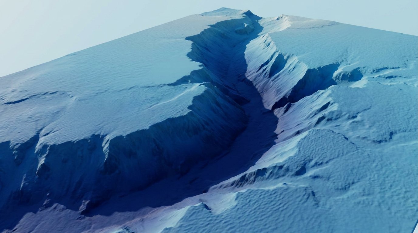
What are the official coordinates of Zhemchug Canyon?
Large undersea features are named and located internationally by the Sub-Committee on Undersea Feature Names (SCUFN), a joint body of the International Hydrographic Organization and UNESCO’s Intergovernmental Oceanographic Commission. It maintains the GEBCO Gazetteer of Undersea Feature Names, the standard reference for where named ridges, seamounts, trenches and canyons lie.
In 2018, scientists from NOAA’s Alaska Fisheries Science Center, Mark Zimmermann and Megan Prescott, submitted a set of proposals to SCUFN that updated the names and positions of the Bering Sea canyons using new bathymetric compilations. For Zhemchug Canyon, they proposed a name point at 58°01.8′N, 174°49.2′W, at a depth of about 3,016 metres. In decimal degrees that is roughly 58.03°N, 174.82°W. A name point is the place where a label is put on a chart or in the gazetteer; for a canyon, it is placed along the main channel, so it does not represent the canyon’s head on the shelf or its mouth on the basin floor.
The same proposal described the canyon as a line rather than a single point. Its traced channels start at shelf depths of about 64 to 68 metres, one near 58°17.5′N, 169°41′W and another as far north as 60°45′N, 171°37′W, and run down to a deep end near 56°10.4′N, 179°56.8′W at about 3,811 metres. That deep end lies almost on the 180th meridian, so the canyon system spans nearly ten degrees of longitude from its shallowest feeder channels to its outlet.
Why is it hard to give one coordinate for a canyon?
A mountain has a summit and a lake has a centre, but a submarine canyon is a long, branching valley. Zhemchug is often described as T-shaped or two-armed: two large branches cut into the shelf edge and merge into a single trunk that runs down the continental slope to the basin. Each branch is itself larger than most continental-margin canyons elsewhere, such as Monterey Canyon off California. Where you put the dot depends on what you are trying to mark.
Older references, including the GEBCO gazetteer and the US Advisory Committee on Undersea Features, recorded Zhemchug as a single point. GEBCO’s gridded bathymetry shows it as a line along the channel, the “thalweg”, the deepest path along the valley floor. NOAA’s 2018 proposal asked that both records be updated so that the canyon was represented consistently. Because of these different conventions, websites, atlases and apps can give coordinates for Zhemchug Canyon that differ by tens of kilometres, all of which may be valid for some part of the canyon.
How big is the area the canyon covers?
The NOAA proposal measured the traced length of the canyon system at about 1,054 km and its width at about 35 km, with a total relief, from the shallowest feeder channel to the deepest point, of about 3,750 metres. These figures describe the whole channel network, from the shelf to the basin, and are larger than the more commonly quoted figure for the canyon’s main incision. Geologists who compared the world’s largest submarine canyons, notably William Normark and Paul Carlson of the US Geological Survey, gave Zhemchug a vertical relief of about 2,600 metres, a drainage area of about 11,350 km² and a volume of about 5,800 km³. An earlier USGS study led by David Scholl in 1970 estimated the excavated volume at about 8,500 km³. Either way, it is far larger than most submarine canyons, which hold less than 500 km³.
Who mapped Zhemchug Canyon first?
The GEBCO gazetteer credits the discovery of the canyon to two Soviet fishery vessels, Zhemchug and Pervenets, in 1958, during the expansion of Soviet trawling and research in the eastern Bering Sea. Both ships gave their names to canyons: Zhemchug and the more northerly Pervenets Canyon. Zhemchug is Russian for “pearl”.
NOAA’s 2018 review found an earlier record. In 1953 the US Coast and Geodetic Survey ship Pioneer ran a sounding survey across the area and charted the feature, labelling it “Marine Canyon” on a survey sheet that was then classified as confidential. Because that survey was not public and the name Zhemchug had been in wide use for decades, the NOAA authors recommended keeping the established name. In the 1960s, American geologists led by David Scholl of the USGS mapped the Bering Sea canyons in detail with echo sounders and seismic profiles, and their 1970 paper in Marine Geology established Zhemchug as possibly the largest submarine canyon on Earth.
Whose waters is Zhemchug Canyon in?
Zhemchug Canyon lies within the United States Exclusive Economic Zone off Alaska, east of the maritime boundary agreed between the United States and the Soviet Union in 1990. Fisheries there are managed by the North Pacific Fishery Management Council and NOAA Fisheries, and the canyon is part of the federal Bering Sea and Aleutian Islands management area. That is why most scientific surveys of the canyon, including camera and trawl surveys of its corals and fish, have been carried out by NOAA’s Alaska Fisheries Science Center. The deep outlet of the canyon, near the 180th meridian, lies close to the edge of the US zone, beyond which the central Bering Sea includes an area of high seas known as the Donut Hole.
How would you get to Zhemchug Canyon?
There is no practical way for a tourist to visit Zhemchug Canyon. It lies far offshore in water that is ice-influenced in winter and often stormy at any time of year, and its rim is more than a hundred metres below the surface. The ocean above the canyon looks like any other patch of the Bering Sea. Most people who have been there are fishermen, crew on research vessels, or the small number of scientists and activists aboard the Greenpeace ship Esperanza in 2007, when marine ecologist Michelle Ridgway piloted a small submersible into the canyon.
The usual route to the canyon starts at Dutch Harbor in the Aleutian Islands, the busiest fishing port in the United States by volume, or at St. Paul Island. From Dutch Harbor a research or fishing vessel would steam north-west for well over a day. Commercial vessels cross the area constantly, because the shelf edge and the canyons are among the richest fishing grounds in the Bering Sea, with pollock, Pacific cod, flatfish and snow crab.
How do scientists find their way around the canyon?
Modern research vessels navigate with satellite positioning and map the seafloor beneath them with multibeam echo sounders, which sweep a fan of sound beams across the bottom and produce a detailed depth model. Much of what we know about the shape of Zhemchug comes from combining older single-beam soundings with these newer surveys. Submersibles and remotely operated vehicles are guided to precise spots on the canyon walls using acoustic positioning systems that track them from the ship. Fisheries scientists also use the canyon coordinates to plan stratified trawl and camera surveys along the eastern Bering Sea slope, which NOAA has run regularly for decades.
What is near Zhemchug Canyon?
Several neighbouring features help place Zhemchug on a map. To the south-east lies Pribilof Canyon, which cuts the shelf edge south of the Pribilof Islands and joins Bering Canyon, the longest of the group, at about 400 km, which runs north-west from near Unimak Island in the Aleutians. To the north of Zhemchug lie the smaller Pervenets and Navarin canyons, and between the canyons the shelf edge forms broad spurs, including the Zhemchug Spur and the Saint Paul Spur. The Pribilof Islands themselves are a summer home to roughly half the world’s northern fur seals, which travel out to feed over the shelf edge and the canyons.
| Feature | Approximate position | Relation to Zhemchug |
|---|---|---|
| Zhemchug Canyon name point | 58°02′N, 174°49′W | Main channel |
| Deep end of channel | 56°10′N, 179°57′W | Outlet near the 180th meridian |
| St. Paul Island | About 57°N, 170°W | About 170 miles to the south-east |
| Bering Canyon | About 54°12′N, 168°15′W | Longest Bering Sea canyon |
| Pribilof Canyon | South of the Pribilofs | Neighbouring canyon to the south-east |
| Pervenets and Navarin canyons | North-west of Zhemchug | Smaller canyons to the north |
Where was the canyon during the Ice Age?
The canyon’s position looks very different when sea level changes are taken into account. During the coldest phases of the last ice age, around 20,000 years ago, global sea level stood roughly 120 metres lower than today. Much of the shallow Bering Sea shelf was then dry land, part of the region known as Beringia, which linked Siberia and Alaska and allowed people and animals to cross between Asia and the Americas. At those times, the outer edge of the shelf, where Zhemchug Canyon begins, lay much closer to the coastline.
That geography is central to how geologists explain the canyon. In their 1970 study, David Scholl and colleagues argued that Zhemchug and Pribilof canyons formed largely during the Pleistocene, when lowered sea levels may have allowed large Alaskan rivers, the Yukon and the Kuskokwim, to discharge sediment near the canyon heads. Masses of unstable sediment piled up on the outer shelf and upper slope, then slid and flowed downslope into the deep basin, eroding the canyon as they went. The canyon’s location also followed older structure: it sits over down-faulted basins in the underlying rock that had been filled with softer sediment, which was easier to carve away. So the coordinates of the canyon are not random. They mark a place where ancient rivers, sediment supply and buried geological structure came together.
Why is the canyon’s location so rich in life?
Zhemchug Canyon lies along what oceanographers call the Bering Sea “Green Belt”, a band of high productivity along the shelf break described by Alan Springer, Peter McRoy and Mikhail Flint in 1996. Here, nutrient-rich water from the deep basin is brought up and mixed onto the shelf edge by currents, tides and eddies, fuelling dense blooms of phytoplankton. Large canyons such as Zhemchug and Pribilof enhance that exchange, channelling deep water towards the shelf. The result is a concentration of zooplankton, fish, squid, seabirds and marine mammals above and around the canyons. The 2007 submarine dives reported dense zooplankton throughout the water column, and the waters above the canyon are feeding grounds for northern fur seals, whales and the endangered short-tailed albatross. A position on a map, in other words, also describes a meeting point of ocean currents.
Why do these coordinates matter?
Exact positions matter for more than labelling charts. Fishery managers draw closure areas and survey strata using coordinates, and the debate in the 2000s and 2010s over whether to protect corals and sponges in Zhemchug and Pribilof canyons turned on exactly where habitat lay relative to fishing effort. Seafloor mapping has also become a diplomatic and scientific priority, because much of the ocean floor is still poorly charted. Accurate positions for big features like Zhemchug help connect old surveys with new data, and make it possible to compare the canyon with others around the world.
What are the coordinates of Zhemchug Canyon?
Its official name point is about 58°01.8′N, 174°49.2′W, at about 3,016 m depth.
How far is Zhemchug Canyon from land?
About 170 miles (275 km) north-west of St. Paul Island in the Pribilofs.
Is Zhemchug Canyon in US or Russian waters?
It lies in the US Exclusive Economic Zone off Alaska.
Why do sources give different coordinates?
The canyon is a long branching valley, so different references mark different points along it.
Who discovered Zhemchug Canyon?
It was first charted by the US ship Pioneer in 1953 and named after a Soviet vessel that surveyed it in 1958.
Can you visit Zhemchug Canyon?
Not as a tourist. It is far offshore and its rim lies over 100 m below the surface.
- Zimmermann, M. & Prescott, M. (2018). Proposal for Zhemchug Canyon, IHO-IOC SCUFN 31. NOAA Alaska Fisheries Science Center.
- Scholl, D.W., Buffington, E.C., Hopkins, D.M. & Alpha, T.R. (1970). The structure and origin of the large submarine canyons of the Bering Sea. Marine Geology 8: 187–210.
- Normark, W.R. & Carlson, P.R. (2003). Giant submarine canyons: Is size any clue to their importance in the rock record? GSA Special Paper 370.
- Rozell, N. (2007). A visit to one of Earth’s great canyons. Alaska Science Forum, Geophysical Institute, University of Alaska Fairbanks.
Blane Perun has been exploring Earth’s oceans and marine life for over 25 years. Founder of TheSea.Org in 1999, underwater photographer, coral aquaculture pioneer, and explorer of 80+ countries.
About Blane Perun →