Where Is the Southern Ocean on a World Map? — Finding the Ocean Around Antarctica
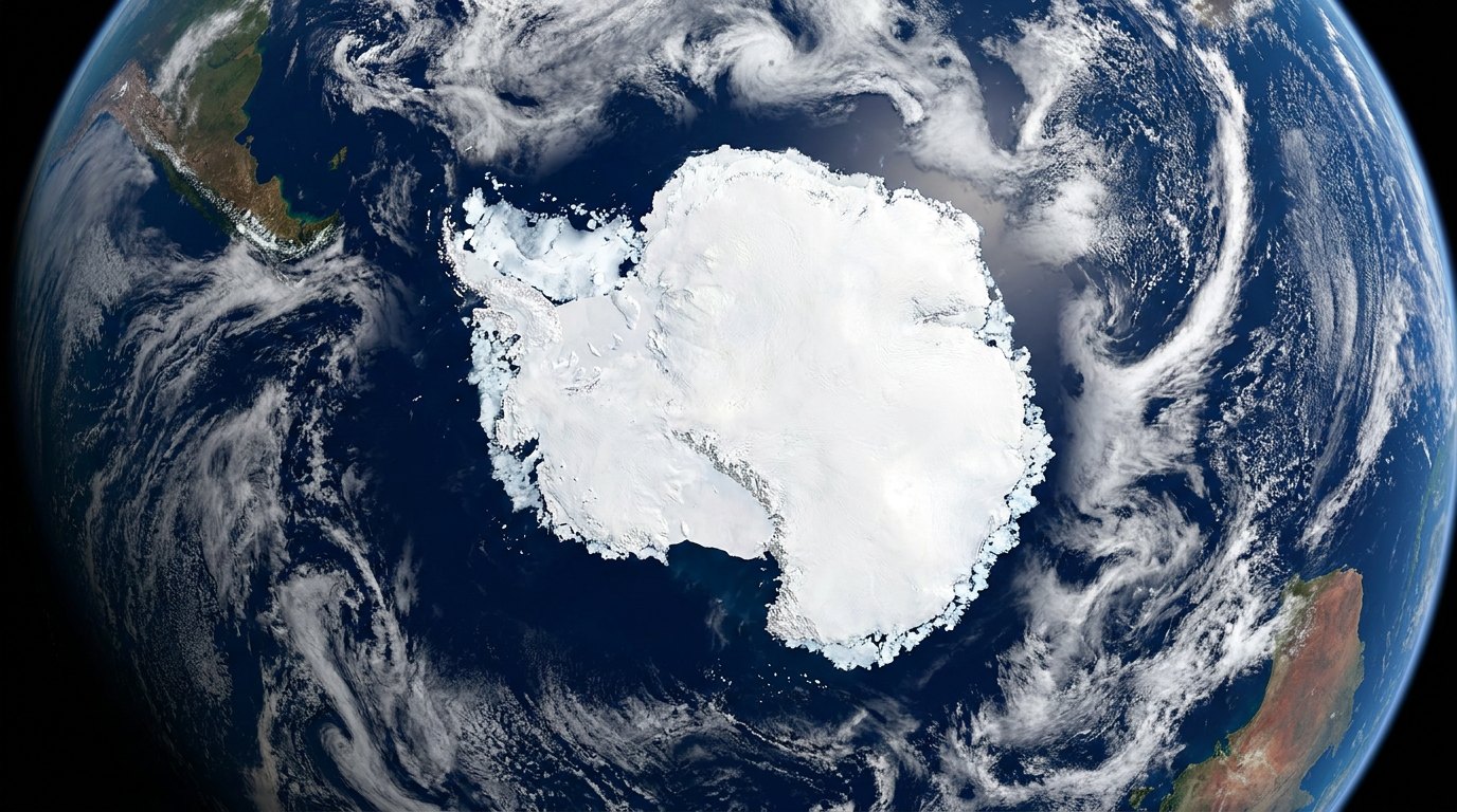
On a world map the Southern Ocean is the ring of water surrounding Antarctica. Its southern edge is the Antarctic coast; its northern edge is usually drawn at 60° South, where it meets the Atlantic, Indian and Pacific Oceans. On rectangular world maps it appears as a stretched band along the bottom; a map centred on the South Pole shows its true shape, a ring about 20.3 million km² in area.
Mapmakers usually use the 60°S line. Many scientists prefer the Antarctic Convergence, a natural front between cold Antarctic water and warmer water to the north that lies roughly between 50°S and 60°S and shifts with the seasons.
Look for the Southern Ocean on a typical classroom world map and you may struggle to find it. It sits along the bottom edge, often unlabelled, stretched into a long white-and-blue band beneath South America, Africa and Australia, sometimes cut off by the map’s border. Turn a globe so that you look straight down on the South Pole, and the picture changes completely: a continuous ring of ocean surrounds the frozen continent, connecting the three great oceans to the north. This page explains exactly where the Southern Ocean is, how its boundaries are drawn, and how to read it on different kinds of maps.
Where exactly is the Southern Ocean?
The Southern Ocean is the body of water that completely surrounds Antarctica. Its southern boundary is the coast of the Antarctic continent, including the seaward edges of the floating ice shelves. Its northern boundary is not a coastline but a line drawn across open water. The most widely used line is the parallel of 60° South, the boundary proposed by the International Hydrographic Organization in 2000 and used by the US government and National Geographic.
At 60°S, the Southern Ocean meets three other oceans. South of Africa it borders the Atlantic, south of the Indian Ocean basin and Australia it borders the Indian Ocean, and south of New Zealand and across to South America it borders the Pacific. There is no wall of land between them, which is why the Southern Ocean is often described as the ocean that connects the others.
Why does it look so strange on world maps?
Most world maps use a projection, a mathematical way of flattening the curved surface of the globe onto a flat sheet. Every projection distorts something. The Mercator projection, still familiar from classroom walls and online maps, keeps the shapes of small areas correct but stretches regions more and more as they approach the poles. Antarctica, a roughly circular continent, becomes a vast white band across the bottom of the map, and the ocean around it is stretched along with it. On many Mercator maps the poles cannot be shown at all, because the projection stretches them to infinity, so the map simply stops somewhere in the Southern Ocean.
Other projections, such as the Robinson or Winkel tripel projections used by many atlases, distort less, but they still split the ring of the Southern Ocean along the bottom edge of the map. Only a polar projection, centred on the South Pole, shows the Southern Ocean as it really is: a broad ring around a central continent.
How can you find it on a globe or online map?
On a globe, turn it until you are looking straight down on Antarctica. The Southern Ocean is the band of water between the Antarctic coast and the line of latitude marked 60°S. On most globes, that line is printed or can be estimated two-thirds of the way between the Antarctic Circle at about 66.5°S and the tip of South America.
On digital globes and map apps that let you tilt and rotate the view, zoom out until the whole Earth is visible and drag Antarctica to the centre of the screen. Flat online maps that use the Mercator projection are the least helpful, because they hide or distort the polar regions.
What land lies nearest to the Southern Ocean?
South America comes closest. The Drake Passage separates Cape Horn from the Antarctic Peninsula and is the narrowest gap between Antarctica and any other continent, roughly 800 kilometres wide. Under the 60°S definition, only the southern part of that passage is in the Southern Ocean; the waters immediately off Cape Horn, at about 56°S, belong to the Atlantic and Pacific.
Australia, New Zealand and South Africa all lie well north of 60°S, so none of them borders the Southern Ocean under that definition. Australia, however, has used a broader definition in which the waters directly south of its own coast are called the Southern Ocean, and Australians commonly use the name for the sea off their southern shores. That is one reason the same water can carry different names on different maps.
Which seas are part of the Southern Ocean?
Several large seas indent the Antarctic coast and form part of the Southern Ocean. The Weddell Sea lies east of the Antarctic Peninsula, south of the Atlantic, and is famous for its heavy pack ice. The Ross Sea lies south of New Zealand and is home to the Ross Ice Shelf, the largest ice shelf on Earth. The Amundsen and Bellingshausen Seas lie along the coast of West Antarctica, facing the Pacific, and the Scotia Sea lies between the Antarctic Peninsula and the islands of the Scotia Arc.
Smaller named seas, such as the Davis, Mawson, Cosmonauts, Cooperation, Lazarev, Riiser-Larsen and D’Urville Seas, run around the coast of East Antarctica. On many world maps these smaller seas are not labelled at all, but they appear on detailed Antarctic charts and polar maps.
Which islands are in the Southern Ocean?
Under the 60°S definition, the main island groups are the South Shetland Islands and South Orkney Islands, off the Antarctic Peninsula, the southern end of the South Sandwich Islands, and isolated islands such as the Balleny Islands south of New Zealand and Peter I Island in the Bellingshausen Sea. Many smaller islands hug the Antarctic coast.
Some famous sub-Antarctic islands lie north of 60°S and so are technically outside the Southern Ocean on most maps. South Georgia, at about 54°S, is the best example: its wildlife and climate are Antarctic in character, and it lies south of the Antarctic Convergence, but under the 60°S line its waters are part of the Atlantic. Kerguelen, Heard and Macquarie Islands are similar cases in the Indian and Pacific sectors. If the Convergence were used as the boundary, all of them would fall inside the Southern Ocean.
How did early maps show the far south?
For centuries, European maps filled the bottom of the world with an imagined continent, Terra Australis Incognita, the unknown southern land. Geographers reasoned that a great landmass must exist in the south to balance the continents of the north, and maps such as Abraham Ortelius’s world map of 1570 showed it sprawling across much of the Southern Hemisphere. As voyages pushed further south and found open water, the imagined continent shrank. James Cook’s circumnavigation of high southern latitudes in the 1770s showed that any southern land must lie within the ice, far smaller and colder than the old maps suggested. The water that replaced it on later maps is today’s Southern Ocean.
How do travellers reach the Southern Ocean?
Most visitors cross into the Southern Ocean on expedition cruises to the Antarctic Peninsula, departing from Ushuaia in Argentina and sailing south across the Drake Passage, a crossing that usually takes about two days and is known for rough seas. Others fly from Punta Arenas in Chile to the South Shetland Islands and join a ship there. Voyages to the Ross Sea usually leave from New Zealand or from Hobart in Tasmania and take considerably longer, and some ships sail from Cape Town towards the coast of East Antarctica. On the way south, passengers often notice the drop in water temperature and the change in seabirds as the ship crosses the Polar Front, the natural edge of the Southern Ocean, before it reaches the 60°S line on the chart.
What is the Antarctic Convergence?
The Antarctic Convergence, also called the Polar Front, is a zone where cold, relatively fresh Antarctic surface water flowing north meets warmer, saltier sub-Antarctic water and sinks beneath it. Sea-surface temperatures can change by several degrees across the front within a short distance, and the plankton, fish and seabirds on either side are noticeably different.
The Convergence circles Antarctica, generally between about 50°S and 60°S, but its position varies with longitude, season and year. Because it marks a real change in the ocean, many oceanographers and biologists consider it the natural northern boundary of the Southern Ocean. The Convention for the Conservation of Antarctic Marine Living Resources uses it to define the area it manages, which is why fisheries maps of the region often show a wavy line rather than a straight parallel.
How does the Antarctic Circumpolar Current fit on the map?
The Antarctic Circumpolar Current flows from west to east all the way around Antarctica, roughly following the Polar Front and the band between about 45°S and 60°S, depending on location. It is the only current that circles the globe unimpeded by land, and its path squeezes through the Drake Passage before spreading out again in the Scotia Sea. On ocean-current maps it appears as a broad eastward-flowing ring around the bottom of the world, the feature that makes the Southern Ocean a distinct ocean.
How big is the Southern Ocean compared with the others?
Using the 60°S boundary, the Southern Ocean covers about 20.3 million square kilometres, slightly more than twice the area of the United States. That makes it the fourth largest of the five oceans, larger only than the Arctic. The Pacific is by far the largest, followed by the Atlantic and Indian Oceans. With a boundary drawn at the Convergence, the Southern Ocean would be considerably larger.
How does its size change through the year?
The map of the Southern Ocean changes dramatically with the seasons because of sea ice. At its minimum, in late summer around February and March, the pack ice covers roughly 2.6 million square kilometres, mostly in the Weddell Sea and along parts of the coast. By its maximum, around September, it covers about 18.8 million square kilometres, an area larger than Antarctica itself. In winter the sea ice reaches out to about 55°S in the Atlantic sector and 65°S in the Pacific sector.
Satellite maps show this as a white ring that grows and shrinks each year, effectively doubling the size of the frozen continent in winter. In recent years Antarctic sea ice has fallen to record lows, and maps of the ice edge have become an important way of tracking climate change.
Which countries claim land beside it?
Seven countries have made territorial claims in Antarctica: Argentina, Australia, Chile, France, New Zealand, Norway and the United Kingdom. Several of these claims overlap, and they are not recognised by most other nations. Under the Antarctic Treaty of 1959, which applies to the area south of 60°S, the claims are frozen: neither recognised nor rejected, and no new claims can be made. The treaty sets aside the region for peaceful purposes and scientific research.
Political maps sometimes show these claims as wedge-shaped sectors radiating from the South Pole, extending out over the Southern Ocean. Those wedges do not represent recognised national waters, and the treaty’s 60°S boundary is one reason the same latitude became the most widely used limit of the Southern Ocean.
How do mapmakers label it today?
Since National Geographic recognised the Southern Ocean in 2021, its maps label the waters around Antarctica as the Southern Ocean, with the boundary at 60°S. Many other publishers, government agencies and online mapping services also label it, though practice is not universal and some maps still show the Atlantic, Indian and Pacific extending to Antarctica. On older maps, or in some languages, you may see the name Antarctic Ocean instead.
What time zone is the Southern Ocean in?
Like the other oceans, the Southern Ocean spans every line of longitude and therefore every time zone. Research stations in Antarctica usually keep the time of the country that supplies them, so a station on the Ross Sea may run on New Zealand time while one on the Antarctic Peninsula keeps Chilean or Argentine time. On a polar map, the time zones converge like slices of a pie at the South Pole, a vivid reminder of why the Southern Ocean is best viewed from above.
Where is the Southern Ocean on a map?
It surrounds Antarctica, from the Antarctic coast north to about 60°S.
Why is it hard to see on world maps?
Flat projections stretch the polar regions into a band along the bottom edge.
What oceans border the Southern Ocean?
The Atlantic, Indian and Pacific Oceans.
Which continent is closest?
South America, across the Drake Passage.
Is South Georgia in the Southern Ocean?
Not under the 60°S line, though it lies south of the Antarctic Convergence.
How big is the Southern Ocean?
About 20.3 million km², the second-smallest ocean.
What is the Antarctic Convergence?
A front where cold Antarctic water meets warmer water to the north, between about 50°S and 60°S.
- CIA World Factbook, Southern Ocean (geography), via IndexMundi
- International Hydrographic Organization, Circular Letter 55/2001, draft 4th edition of S-23
- Smithsonian Magazine (2021), Wave hello to Earth’s newest ocean
- Antarctic Treaty (1959), Article VI, area of application
Blane Perun has been exploring Earth’s oceans and marine life for over 25 years. Founder of TheSea.Org in 1999, underwater photographer, coral aquaculture pioneer, and explorer of 80+ countries.
About Blane Perun →