Dolphins in Marco Island — Resident Bottlenose on the Edge of the Ten Thousand Islands
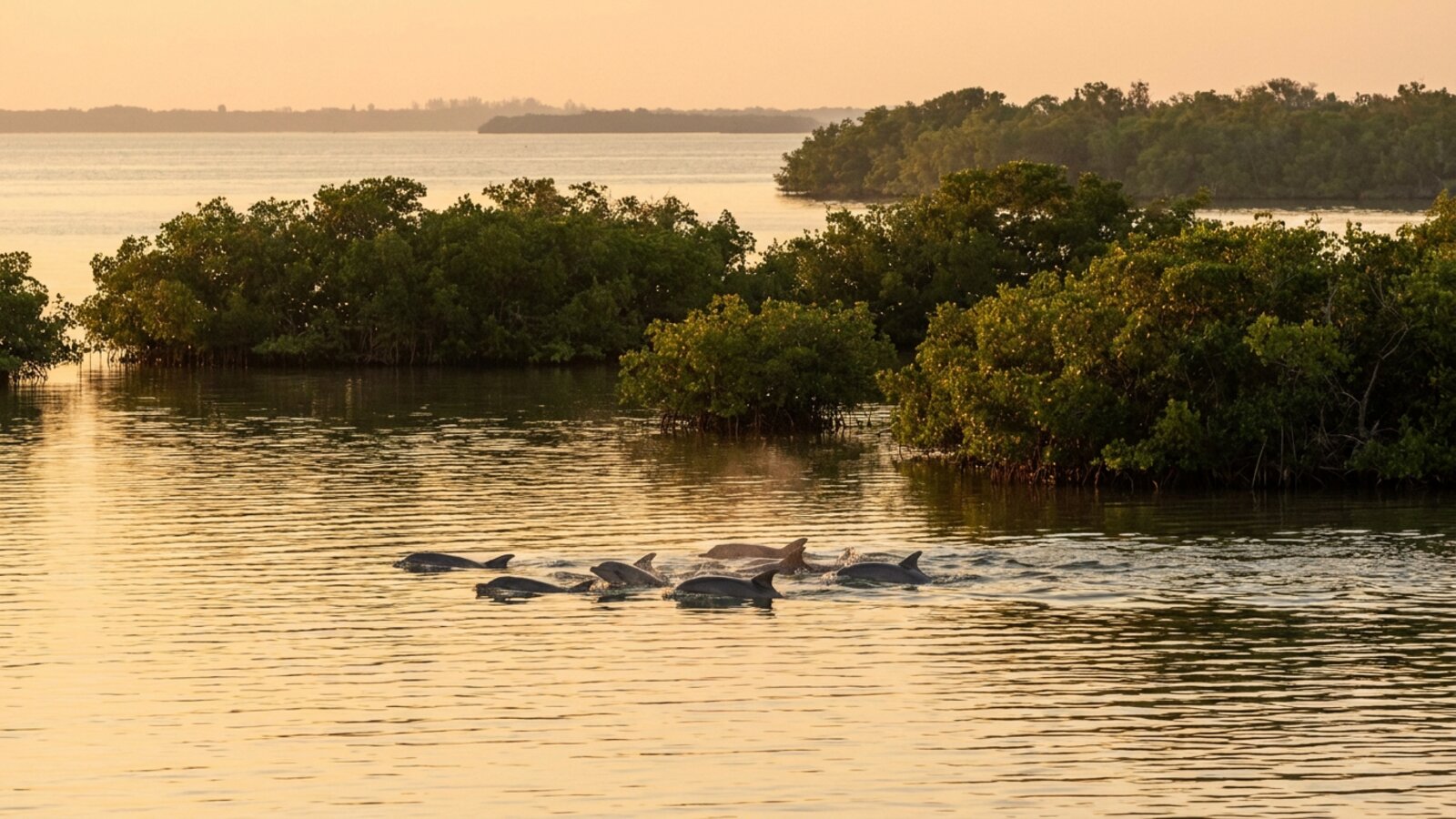
Marco Island has wild bottlenose dolphins all year. They feed in the tidal passes (Capri Pass, Big Marco Pass and Caxambas Pass), the Marco River, and the mangrove channels of Rookery Bay and the Ten Thousand Islands. Boat tours, including the 10,000 Islands Dolphin Project research cruise aboard the Dolphin Explorer, photograph fins to track individual dolphins over years. Keep 50 yards away and never feed them.
The best places are where water moves: the passes on either end of the island, the Marco River, and the channels leading into Rookery Bay and the Ten Thousand Islands. Dolphins also travel the Gulf beaches, including South Beach near Caxambas Pass and the Tigertail Beach lagoon area, and can be seen from shore on calm mornings. Kayak and paddleboard trips through the mangroves often meet them in shallow channels.
Why are there so many dolphins around Marco Island?
Rich estuaries: mangroves and seagrass feed the fish that feed the dolphins.
Marco Island sits at the northern edge of the Ten Thousand Islands, a maze of mangrove islands and tidal creeks that stretches south into Everglades National Park. Mangrove roots and seagrass beds are nurseries for mullet, pinfish, snook, sheepshead and shrimp, and strong tidal flows through the passes concentrate prey. Much of the surrounding water is protected within the Rookery Bay National Estuarine Research Reserve, about 110,000 acres of mangrove forest, bays and uplands, which keeps the habitat productive.
| Area | What dolphins do there | How to see it |
|---|---|---|
| Capri Pass and Big Marco Pass | Feed in tidal current | Boat tours, north end |
| Caxambas Pass and South Beach | Travel and feed along the beach | From shore at dawn |
| Marco River | Commute between bays and Gulf | Bridge and boat views |
| Rookery Bay channels | Hunt in shallow mangrove creeks | Guided kayak trips |
| Ten Thousand Islands | Resident groups, mothers and calves | Longer boat trips |
What is Rookery Bay?
Rookery Bay National Estuarine Research Reserve is the protected backdrop to most Marco Island dolphin watching. Designated in 1978, it covers about 110,000 acres, beginning about five miles south of Naples and taking in the coast between Naples and the Ten Thousand Islands. About 70,000 acres, or 64% of the reserve, is open water: bays, passes, tidal creeks and nearshore Gulf. The remaining 40,000 acres are mostly mangrove forest, fresh to brackish marshes and uplands. More than 150 bird species use the reserve, and its wildlife includes threatened and endangered animals such as the Florida panther.
Rookery Bay is one of 30 reserves in the US National Estuarine Research Reserve System. It is managed by the Florida Department of Environmental Protection with funding and technical support from NOAA. Reserves in the system run long-term water-quality monitoring, and Rookery Bay’s stations report data every ten minutes. For dolphins, those measurements of salinity, temperature, dissolved oxygen and turbidity describe the conditions in which their prey live, and they can show when a red tide or a pulse of polluted fresh water is moving through the estuary.
The reserve’s value to dolphins lies in its mix of habitats. Mangrove-lined creeks and seagrass flats shelter juvenile fish, and the tidal passes channel those fish past waiting predators twice a day. Dolphins that know the area well can move between quiet back bays, where calves are safer, and the passes and beaches, where feeding is more productive. Long-term studies elsewhere on the coast, such as in Sarasota Bay, show that many inshore bottlenose dolphins belong to resident communities that stay in the same area for years rather than wandering widely.
Are Marco Island dolphins different from offshore dolphins?
Yes. Common bottlenose dolphins form two broad ecotypes. Coastal dolphins, like those around Marco Island, are adapted to warm, shallow water. They are generally smaller, with proportionally larger flippers that help with manoeuvring in shallow channels and with shedding heat. Offshore dolphins are larger and darker, with relatively shorter fins and beaks, and blood characteristics suited to deeper diving. Some offshore populations travel up to 4,200 km in a season, while inshore groups tend to stay put. Worldwide, the common bottlenose dolphin has been estimated at about 600,000 animals.
For a dolphin watcher, this means that the dolphins seen from a Marco Island tour boat are probably local animals with a home range covering the passes, Rookery Bay and nearby parts of the Ten Thousand Islands. Offshore bottlenose dolphins and other species, such as Atlantic spotted dolphins, live farther out on the West Florida Shelf and are rarely seen on short inshore trips.
How does photo-identification work?
Dolphins mark one another. When bottlenose dolphins interact, they often grab each other with their teeth, and over time those encounters leave nicks and notches along the trailing edge of the dorsal fin. Combined with scars and the fin’s shape, the notches make most adults individually recognisable from a good side-on photograph. Researchers build a catalogue of fin images and, on each survey, match new photos against it. That is the method used aboard the Dolphin Explorer, and it is used by dolphin studies worldwide.
The best example of what long-term photo-ID can reveal is the Sarasota Bay study roughly 100 miles to the north. By 2016 its dataset covered more than 45 years, more than 32,000 sightings of dolphin groups and more than 1,100 individual dolphins, making it the most comprehensive long-term record of any free-ranging dolphin population. Records like these let scientists measure how long dolphins live, how often females give birth, and how they respond to threats such as red tide and human feeding.
Long-term tracking can also reveal how long dolphins live in the wild. In the Mississippi Sound, 50 dolphins were freeze-branded during a 1982 health assessment. Photo-ID surveys from 2011 to 2026 re-sighted 10 of them; seven of those still alive are over 30 years old, and one is confirmed to be 47 as of 2026. Some had stayed in the same area for decades.
Fin catalogues also record family life. Female bottlenose dolphins give birth to a single calf after a gestation of about a year. Newborns are 0.8–1.4 m long and weigh 15–30 kg, nurse for 18–20 months, and may stay with their mothers until they are three to eight years old. Females typically calve every three to six years, and males often form alliances to court females. Wild bottlenose dolphins live at least 40 years and up to about 60, with females usually outliving males. A Marco Island calf photographed today could still be swimming in the passes in the 2060s.
What is the 10,000 Islands Dolphin Project?
A long-running citizen-science photo-ID study run from tour boats out of Marco Island.
Aboard the Dolphin Explorer, a catamaran running roughly three-hour trips (a 2015 travel report described a 30-foot boat; a 2026 listing describes a 47-foot catamaran) into the Gulf and nearby estuaries, a naturalist photographs every dolphin’s dorsal fin. Nicks and notches on a fin are as individual as a fingerprint, so photos let the team recognize the same dolphins year after year, recording their sex, associations, calves and feeding habits. Guests often see up to 20 dolphins per trip and help log sightings. Photo-ID is the same method used by long-term studies like the Sarasota Dolphin Research Program farther north. See dolphin fin vs shark fin for why fins are so useful.
How does red tide affect Marco Island dolphins?
Red tide toxins can sicken and kill dolphins, mostly through contaminated fish.
Southwest Florida is the heart of Florida red tide, blooms of the alga Karenia brevis that release brevetoxins. Dolphins absorb the toxin by eating contaminated fish and breathing toxic sea-spray aerosols. During the severe 2017–2019 bloom, NOAA declared an unusual mortality event, covering 1 July 2018 to 30 June 2019, for bottlenose dolphins in Southwest Florida. Red tide also reduces the fish dolphins depend on. Water quality in the Caloosahatchee and Everglades systems is closely tied to these blooms.
What did the 2018–2019 dolphin die-off show?
NOAA’s unusual mortality event ran from 1 July 2018 to 30 June 2019 and covered seven counties on the southwest coast: Collier, Lee, Charlotte, Sarasota, Manatee, Hillsborough and Pinellas. Collier County includes Marco Island. In that year, 183 bottlenose dolphins were found stranded. Of 132 dolphins tested, 126 (95%) had brevetoxin at background levels or higher in at least one tissue, and 74 (56%) had high concentrations above 200 ng/g. Scientists attributed the event to brevetoxin exposure from the Karenia brevis bloom. The UME is now closed, with follow-up monitoring of strandings and future blooms.
Karenia brevis is a single-celled dinoflagellate 20–40 micrometres across that swims with two flagella and tends to move toward light, keeping it near the surface. It grows best at 22–28 °C and in salty water, and it can use both organic and inorganic nitrogen and phosphorus. The organism was first identified in Florida in 1947, but descriptions of large fish kills in the Gulf go back to Spanish explorers in the 16th century, including Cabeza de Vaca.
Red tide hurts dolphins indirectly as well. In Sarasota Bay, underwater listening stations recorded a quick, sustained drop in sound levels across frequencies used by soniferous fish after K. brevis cells arrived. Fish catch rates and species counts fell at the same time, and marine mammal deaths in the region increased. For a dolphin, a bloom can mean poisoned prey and also far less food. Manatees, which share the same channels around Marco Island, are also killed by brevetoxins, which can weaken their immune systems.
How are red tides tracked?
Spotting a bloom early gives managers and boat operators time to warn the public and watch for sick wildlife. Traditional monitoring relies on collecting water samples and counting K. brevis cells under a microscope, which is slow and labour-intensive. Newer tools speed this up. The Brevebuster is an optical instrument that can be mounted on a fixed platform or an autonomous underwater vehicle and detects the bloom’s distinctive pigments in the water. Molecular tests, including real-time PCR and an RNA-based assay that targets a K. brevis gene, can confirm and count cells in a water sample within hours.
Satellites add the big picture. Ocean-colour sensors such as MODIS and the European MERIS instrument have been used to map blooms from space, picking out K. brevis by its chlorophyll fluorescence and the way it scatters light. For seafood safety, laboratory tests such as ELISA and liquid chromatography–mass spectrometry can detect brevetoxins in shellfish more sensitively than the older mouse bioassay. None of these tools can stop a bloom, but together they show where red tide is moving along the Collier County coast, which helps explain dolphin and manatee strandings when they happen.
Why do Everglades dolphins carry so much mercury?
The mangrove estuaries south of Marco Island, in the Florida Coastal Everglades, are a known mercury hotspot. A 2024 study comparing dolphins across the US Southeast found some of the highest skin mercury levels in the Everglades, an average of about 10,900 ng/g wet mass, second only to St. Joseph Bay in the Florida Panhandle and about twenty times the levels in Charleston, South Carolina.
A 2026 study of 89 Everglades dolphins found that mercury rose with trophic level and was highest in animals that fed more in estuarine and freshwater food webs, matching the pattern of mercury in their prey. Methylmercury, the form that builds up through food chains, made up 78–100% of the total, and between 55% and 68.5% of the dolphins exceeded the estimated threshold for mercury-related liver disease. Selenium, which can reduce mercury’s toxicity, was also measured. Earlier work found the opposite pattern for PCBs: dolphins in the Lower Florida Keys carried more of these industrial pollutants than Everglades dolphins. Each location has its own mix of contaminants.
These studies concern dolphins living farther south than Marco Island, and no comparable published data were found for the Marco Island dolphins themselves. Because these dolphins live in the same kind of mangrove estuary, long-term monitoring of the local population is worthwhile.
Why is feeding dolphins so harmful?
Feeding wild dolphins is illegal under the US Marine Mammal Protection Act, and long-term research shows why. In Sarasota Bay, a growing share of the resident dolphins has become conditioned to people through direct and indirect food provisioning by people. A 2016 analysis found that dolphins learned the habit from each other, so that associating with already conditioned animals strongly predicted whether a dolphin would start approaching boats. Conditioned dolphins were also more likely to be injured by human interactions than unconditioned animals, with possible consequences for survival.
Begging can also reshape dolphin society. Near Savannah, Georgia, dolphins that forage behind shrimp trawlers formed tighter groups with each other than with other dolphins. The lesson for Marco Island is simple: a dolphin that learns to take fish from a boat or a dock passes the habit on, and it is more likely to be injured by people. Watch from a distance and let them hunt on their own.
How should you watch dolphins around Marco Island?
Slow down, stay back and let dolphins decide.
- Stay at least 50 yards away and limit viewing to 30 minutes.
- Never feed dolphins; it is illegal and teaches them to approach boats.
- Watch for manatees too; much of the area has slow-speed zones.
- Do not chase or box in dolphins, especially mothers with calves.
- Kayakers should hold position quietly rather than paddling toward dolphins.
For more Southwest Florida context, read Marco Island and Naples, Florida, and compare with the Panhandle in dolphins in Destin.
Are there dolphins on Marco Island?
Yes. Wild bottlenose dolphins live in the passes, bays and Ten Thousand Islands all year.
Where is the best place to see dolphins on Marco Island?
Capri Pass, Big Marco Pass, Caxambas Pass and the channels into Rookery Bay.
Can you see dolphins from the beach on Marco Island?
Yes, often at South Beach and near the passes on calm mornings.
What is the Dolphin Explorer?
A Marco Island catamaran that runs research cruises for the 10,000 Islands Dolphin Project, photo-identifying dolphins.
What kind of dolphins live near Marco Island?
Common bottlenose dolphins; other species live far offshore.
Can you swim with dolphins in Marco Island?
You should not approach wild dolphins in the water; it can count as harassment.
Does red tide kill dolphins?
Yes. Brevetoxins from Florida red tide have caused dolphin die-offs in Southwest Florida.
- TravelAge West (2015): Learn about dolphins with the 10,000 Islands Dolphin Project.
- Rookery Bay National Estuarine Research Reserve (NOAA/Florida DEP).
- NOAA Fisheries: 2018–2019 bottlenose dolphin unusual mortality event, Southwest Florida.
- Florida Fish and Wildlife Conservation Commission: Red tide and marine mammals.
- NOAA Fisheries. Unusual Mortality Event: 2018–2019 Southwest Bottlenose Dolphins (closed) (checked 8 Nov 2026).
- NOAA Office for Coastal Management. Rookery Bay National Estuarine Research Reserve (checked 8 Nov 2026).
- Gulfshore Life (2026). Dolphin Explorer listing.
- Christiansen, F. et al. (2016). Food provisioning increases the risk of injury in a long-lived marine top predator. Royal Society Open Science. doi:10.1098/rsos.160560
- Solangi, M. et al. (2026). Dolphin longevity and long-term site fidelity in the Mississippi Sound: insights from a 1982 health assessment. Ecology and Evolution. doi:10.1002/ece3.74432
- Rycyk, A.M. et al. (2020). Passive acoustic listening stations show rapid onset of ecological effects of harmful algal blooms in real time. Scientific Reports. doi:10.1038/s41598-020-74647-z
- Paz, V. et al. (2026). Factors affecting mercury accumulation and toxicological risk in coastal and estuarine bottlenose dolphins within a mercury hotspot. Environmental Research. doi:10.1016/j.envres.2026.126068
- Griffin, M.L. et al. (2024). Spatial variation in mercury accumulation in bottlenose dolphins in southeastern U.S.A. Toxics 12: 327. doi:10.3390/toxics12050327
- Damseaux, F. et al. (2017). Spatial variation in the accumulation of POPs and mercury in bottlenose dolphins of the Lower Florida Keys and the coastal Everglades. Environmental Pollution. doi:10.1016/j.envpol.2016.10.005
- Kovacs, C.J., Perrtree, R.M. & Cox, T.M. (2017). Social differentiation in common bottlenose dolphins that engage in human-related foraging behaviors. PLoS ONE. doi:10.1371/journal.pone.0170151
Blane Perun has been exploring Earth’s oceans and marine life for over 25 years. Founder of TheSea.Org in 1999, underwater photographer, coral aquaculture pioneer, and explorer of 80+ countries.
