Where Do the Indian and Atlantic Oceans Meet? — Cape Agulhas and the 20° East Meridian
By convention, the Indian and Atlantic oceans meet at Cape Agulhas, the southernmost point of Africa, and the boundary runs due south from there along the 20° E meridian to Antarctica. It is not at the Cape of Good Hope, which lies further west on the Cape Peninsula. In the water there is no sharp line: the real meeting zone is a broad, shifting region where the warm Agulhas Current turns back on itself and meets the cold Benguela system.
Why Cape Agulhas and not the Cape of Good Hope?
Because the boundary is a convention, and the convention follows the true southern tip of the continent. The International Hydrographic Organization (IHO), which publishes the standard reference Limits of Oceans and Seas, defines the western limit of the Indian Ocean as running from Cape Agulhas in 20° East, southward along that meridian to the Antarctic continent. Britannica gives the same line and notes that the cape’s meridian is the official boundary between the two oceans.
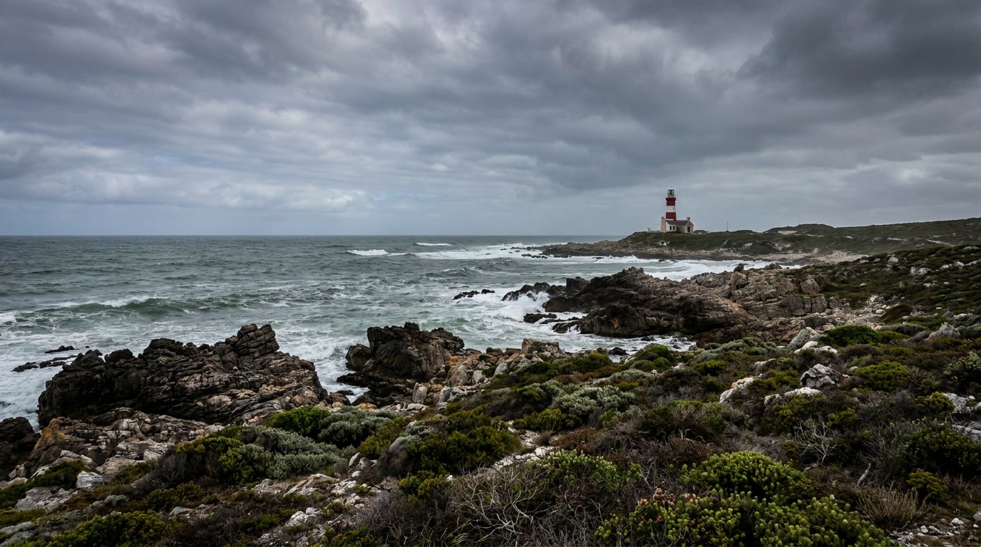
Cape Agulhas lies at about 34°49′ S, 20°01′ E, roughly 176 km southeast of Cape Town. The Cape of Good Hope, by contrast, is at the end of the Cape Peninsula south of Cape Town, well to the west. It is famous, dramatic and easy to reach from the city, and tour guides often call it the place where the two oceans meet, but it lies entirely on the Atlantic side of the conventional line. The confusion is understandable: in everyday speech the Cape of Good Hope has long stood for the whole southern tip of Africa, and its cliffs make a far better photograph than the low, rocky shore at Agulhas.
A boundary that has moved on paper
Ocean boundaries are drawn by people, and the lines have changed over the past century. The first edition of the IHO’s Limits of Oceans and Seas, in 1928, included a Southern Ocean around Antarctica bounded by land: Cape Horn, Cape Agulhas, the southern coast of Australia and New Zealand. In the 1937 second edition the Southern Ocean extended north to 40° S between Cape Agulhas and Cape Leeuwin in Western Australia, which would have put the waters directly south of Africa in a different ocean altogether. The third edition, of 1953, dropped the Southern Ocean and simply ran the Atlantic–Indian line south along 20° E all the way to Antarctica. That is the edition still formally in force.
In 2002 the IHO circulated a draft fourth edition that reinstated a Southern Ocean south of 60° S. It has never been ratified, but many agencies and atlases now use it. Under that scheme, the Atlantic–Indian boundary runs south along 20° E only as far as 60° S, where both oceans give way to the Southern Ocean. Either way, the anchor point on land has stayed the same since 1928: Cape Agulhas.
Can you see where the two oceans meet?
Not as a line in the water. Photos showing two differently coloured seas side by side are usually of sediment plumes, river mouths or glacial meltwater meeting the sea, not of the Indian and Atlantic. A meridian is an imaginary line, and the water does not change at 20° E.
What you can sometimes notice is temperature. The Atlantic coast west of the Cape Peninsula is chilled by the Benguela system and its coastal upwelling, which brings cold water up from depth. East of Cape Agulhas, the coast is bathed by water from the Indian Ocean. The change is not abrupt and does not happen at the cape itself: it shifts with winds, eddies and the seasons, and on any given day the warmest and coldest water may be found well away from the official boundary.
The real meeting: the Agulhas Current and its retroflection
The oceanographic meeting point of the Indian and Atlantic oceans is not a cape but a current. The Agulhas Current is the western boundary current of the southwest Indian Ocean, flowing south along the east coast of Africa from about 27° S to 40° S. It is narrow, swift and strong. Estimates of its net transport start at about 70 sverdrups (70 million cubic metres of water per second) and reach 95 to 136 Sv near the Agulhas Bank; by comparison, the Brazil Current carries about 16 Sv, the Gulf Stream about 34 Sv and the Kuroshio about 42 Sv at comparable latitudes. Its high-speed core averages about 34 km wide, with mean peak speeds of about 1.36 m/s and occasional bursts to about 2.45 m/s. Britannica describes the whole current as about 95 km wide and extending down to about 1,200 m.
The current follows the continental shelf from Maputo to the tip of the Agulhas Bank, about 250 km south of Cape Agulhas. There its momentum carries it off the shelf and out into the southeast Atlantic. Then, sheared by the eastward-flowing Antarctic Circumpolar Current, it turns sharply back on itself, a manoeuvre called the Agulhas Retroflection, and flows east again as the Agulhas Return Current, rejoining the Indian Ocean gyre. Most of the water, up to about 85 Sv, goes back to the Indian Ocean this way. The Benguela oceanography programme places the retroflection, and with it the southern boundary of the Benguela system, typically between 36° and 37° S.
The retroflection is the true meeting place of the two oceans. It sits well to the south and west of Cape Agulhas, in what is conventionally Atlantic water, and it moves. On any given day the place where Indian Ocean water stops and Atlantic water begins can be hundreds of kilometres from the line on the map.
Agulhas leakage: Indian Ocean water in the Atlantic
Not all of the Agulhas Current turns back. Where the retroflection loop pinches off, it periodically releases huge rings of warm water, Agulhas rings, into the South Atlantic. Each ring is estimated to carry 3 to 9 Sv. Together with filaments and direct branches of the current, this “Agulhas leakage” moves as much as 15 Sv of Indian Ocean water directly into the South Atlantic: about 10 Sv of relatively warm, salty thermocline water and about 5 Sv of cold, low-salinity Antarctic Intermediate Water. Indian Ocean surface water arriving this way is around 24 to 26 °C, significantly warmer and saltier than the South Atlantic water around it.
That leakage matters far beyond South Africa. It is a major source of heat and salt for the South Atlantic. Some of it joins the North Brazil Current, crosses the equator, warms further, and eventually feeds the Gulf Stream, where its extra salt helps North Atlantic water become dense enough to sink. In this way, Indian Ocean water arriving around the tip of Africa is thought to contribute to the Atlantic Meridional Overturning Circulation, the system that carries heat north in the Atlantic. Model studies have suggested that the leakage has increased as the Southern Hemisphere westerly winds shifted towards the pole. Looking back in time, studies of seafloor sediments suggest that during the Last Glacial Maximum, about 20,000 years ago, the leakage was considerably weaker, which is one reason the Agulhas system has become a focus of climate research.
The meeting zone is also biologically rich. The Agulhas acts as an ocean convergence zone: surface water is forced down along the current, and cold, nutrient-rich water wells up on its southern side, while plankton tend to be concentrated in and around the current. Satellite maps of chlorophyll show the result most clearly in the Agulhas Retroflection, where concentrations tend to be significantly higher than in the surrounding South Indian and South Atlantic waters. So the place where the two oceans really meet is not just a line of changing temperature but a productive feeding ground for the plankton-based food web.
Water also flows the other way at depth. North Atlantic Deep Water rounds the southern tip of Africa and enters the Indian Ocean, most of it turning east and a smaller part flowing north beneath the Agulhas Current into the Natal Valley. So the two oceans are connected in layers, warm Indian water spilling west near the surface and cold Atlantic water moving east far below.
The Atlantic side: the Benguela upwelling system
West of the cape, the Atlantic coast of southern Africa is dominated by the Benguela Current, which flows north between about 35° and 15° S. According to the Benguela Current Large Marine Ecosystem programme, its total equatorward flow is about 15 to 25 Sv, of which some 7 Sv is water of Indian Ocean origin, much of it delivered by the Agulhas leakage. Winds blowing along the coast drive surface water offshore through a process called Ekman transport, and cold, nutrient-rich water rises to replace it. The principal upwelling cell lies near Lüderitz in Namibia, at about 27° S, where climatological sea surface temperatures run 5 to 6 °C colder than expected for the latitude.
The result is one of the most productive marine ecosystems on Earth, with total primary production roughly comparable to the Humboldt system off Peru and substantially greater than off California. The Benguela is unusual among the great upwelling systems in being bordered at both ends by warm water: the Angola Current to the north, at a front typically between 14° and 17° S, and the Agulhas Current to the south. That makes the southern tip of Africa one of the very few places in the world where a warm western boundary current and a cold eastern boundary upwelling system sit almost side by side.
Why is the sea off Cape Agulhas so dangerous?
The Agulhas Bank is a wide, shallow shelf where strong currents, Southern Ocean swells and storms meet. The danger is greatest where swell runs against the Agulhas Current. An opposing current shortens and steepens waves and can bunch them into groups, producing sudden, unusually steep seas. A 2025 study of an accident involving the cargo ship Beluga Reefer in the Agulhas retroflection zone found that a strong opposing current of about 1.27 m/s steepened waves and compressed wave groups, creating brief hazardous conditions even though the overall sea state, with significant wave heights peaking around 3.2 m, did not look extreme. The authors concluded that visually calm, aligned wave conditions can mask dangerous wave–current interactions.
The same shallow bank that makes the seas so dangerous also makes them rich: Britannica notes that the Agulhas Bank is excellent for trawling. The coast itself is also treacherous. The name Agulhas is Portuguese for “needles.” Britannica gives two explanations: the jagged rocks and reefs that have wrecked many ships, and the observation by early Portuguese navigators that their compass needles showed no magnetic deviation there. Some 150 wrecked ships lie scattered along the South African coast in this region. The Cape Agulhas Lighthouse, whose design was inspired by the Pharos of Alexandria, was completed in December 1848 and first lit on 1 March 1849. Its 27 m tower now houses a museum, and its light has a range of about 30 nautical miles. See is the Indian Ocean dangerous? for the wider picture.
Visiting the meeting point
Cape Agulhas is reached by road from Cape Town via the small town of Bredasdorp; the village of L’Agulhas lies about 30 km south of Bredasdorp. Visitors walk out to the southernmost point of the continent, at the conventional meeting place of the two oceans, and to the historic lighthouse and its museum nearby. The low, rocky shore is much less dramatic than the cliffs of the Cape Peninsula, which is one reason the more spectacular Cape of Good Hope gets the credit in photographs.
If you visit both capes, you will have stood on the Atlantic side at Good Hope and at the conventional junction at Agulhas, and you may well feel a difference in water temperature between the cold Atlantic beaches near Cape Town and the shores further east. Just remember that the real meeting of the oceans is happening offshore, in the restless loop of the Agulhas Retroflection.
Common misconceptions
Three myths come up again and again. The first is that the oceans meet at the Cape of Good Hope; by convention they meet at Cape Agulhas. The second is that you can see a visible line where they meet; there is none, only gradual changes in temperature and colour that move with the currents. The third is that the boundary is a fixed natural feature. It is a line chosen by a hydrographic committee, and the real exchange of water between the two oceans happens tens to hundreds of kilometres offshore, in the loops and rings of the Agulhas Retroflection.
Where do the Indian and Pacific oceans meet?
The Indian–Pacific boundary is usually drawn from South East Cape on Tasmania south along 147° E, and, further north, through the straits and seas of the Indonesian archipelago, where water moves between the two oceans through gaps between the islands. For how far apart these two boundaries are and the overall size of the ocean between them, see how wide is the Indian Ocean?, and for the full ocean profile see our Indian Ocean guide.
Where do the Indian and Atlantic oceans meet?
At Cape Agulhas, South Africa, along the 20° E meridian.
Do the oceans meet at the Cape of Good Hope?
No. That is a popular myth; the conventional boundary is at Cape Agulhas, further east and further south.
Can you see the line where two oceans meet?
No. There is no visible line, though water temperature changes across the region.
What is the Agulhas retroflection?
The sharp turn the warm Agulhas Current makes south of Africa, shedding warm-water rings into the Atlantic.
Which ocean is warmer at the Cape?
The Indian Ocean side, warmed by the Agulhas Current; the Atlantic side is cooled by the Benguela Current.
Who decides ocean boundaries?
The International Hydrographic Organization publishes the standard limits.
- International Hydrographic Organization. Limits of Oceans and Seas, 1st (1928), 2nd (1937) and 3rd (1953) editions; 2002 draft 4th edition (via Wikipedia: Borders of the oceans).
- Britannica: Cape Agulhas; Indian Ocean (boundary at 20° E, Agulhas Current).
- Wikipedia: Agulhas Current; Cape Agulhas Lighthouse; L’Agulhas.
- Benguela Current Large Marine Ecosystem Programme: Oceanography fact file.
- Beal, L.M. et al. (2011). On the role of the Agulhas system in ocean circulation and climate. Nature 472: 429–436. doi:10.1038/nature09983.
- Biastoch, A. et al. (2009). Increase in Agulhas leakage due to poleward shift of Southern Hemisphere westerlies. Nature. doi:10.1038/nature08519.
- Setordjie, V.E. et al. (2025). Wave–current interactions in the Agulhas Retroflection: the Beluga Reefer accident. Journal of Marine Science and Engineering.
Blane Perun has been exploring Earth’s oceans and marine life for over 25 years. Founder of TheSea.Org in 1999, underwater photographer, coral aquaculture pioneer, and explorer of 80+ countries.
About Blane Perun →