Scuba Diving Puerto Rico — Walls, Islands & Clear Blue Water
Puerto Rico’s diving is spread around its coasts and offshore islands. La Parguera on the south coast has The Wall, a drop-off running about 20 miles (32 km) along the shelf edge. Off the west coast, Desecheo Island, a national wildlife refuge 13 miles from Rincón, has visibility of 30–45 m (100–148 ft). Mona Island, 41 miles west in the Mona Passage, offers remote walls such as Carabinero, which drops past 150 m. In the east, Culebra (50+ sites) and Vieques have shallow, easy reefs with nurse sharks and turtles. From roughly December to May, humpback whales pass through the Mona Passage.
Most US divers skip it for the Caymans or Bonaire, but Puerto Rico needs no passport for Americans, has direct flights, and offers genuine wall diving, remote-island expeditions and beginner reefs in one trip.
The west and south (Rincón, Aguadilla, La Parguera) are the base for Desecheo, The Wall and Mona trips. The east (Fajardo) is the hub for Culebra and Vieques, which also have their own small dive shops.
Puerto Rico diving — at a glance
- Signature wall: La Parguera, ~20 mi (32 km) long
- Clearest water: Desecheo Island, 30–45 m visibility
- Remote expedition: Mona Island, 41 mi (66 km) west
- Easy reefs: Culebra (50+ sites), Vieques, Fajardo
- Humpback whales: Mona Passage, ~December–May
- Water temperature: Warm year-round; a 3 mm suit is usual
Where is the best scuba diving in Puerto Rico?
It depends on your level. Experienced divers head for The Wall at La Parguera, Desecheo and Mona Island. Newer divers will love Culebra, Vieques and the reefs off Fajardo.
| Area | Coast | Highlight | Depth | Level |
|---|---|---|---|---|
| La Parguera / The Wall | South | ~20 mi wall; Black Wall, Efra’s Wall, Fallen Rock | Reef from ~20 m, drops past recreational limits | Advanced |
| Desecheo Island | West, 13 mi off Rincón | 30–45 m visibility, caverns, arches | Varies, 24 sites | Intermediate |
| Mona Island | Mona Passage | Remote walls, sharks, dolphins | Carabinero Wall from 6 m to 150+ m | Advanced |
| Culebra | East | 50+ sites, nurse sharks at Cayo Lobito | Mostly shallow | Beginner |
| Vieques | East | Mosquito Pier, Patti’s Reef | 12–30 m max | Beginner–intermediate |
| Fajardo (Sandslide) | Northeast | Turtles, barracuda, morays | 5–24 m | Beginner |
| Rincón (Tres Palmas) | West | Elkhorn coral, shore diving | Shallow | Beginner |
What is The Wall at La Parguera?
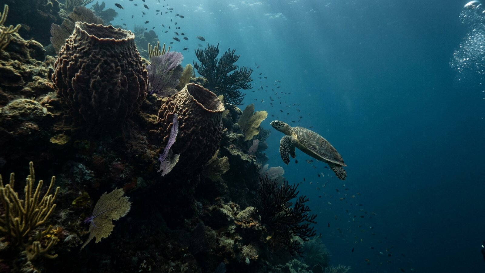
A continuous drop-off along the edge of Puerto Rico’s southern shelf, about 20 miles (32 km) long, off the town of La Parguera in Lajas. Dives start on the reef crest and drop down the face, with sponges, sea fans and plate corals. Named sites include Black Wall, known for its coral garden and macro life, Efra’s Wall with big coral formations, and Fallen Rock, where the reef begins around 20 m (65 ft) and spotted eagle rays and dolphins pass by. It is a deep, blue-water dive best suited to advanced divers. La Parguera is also home to a bioluminescent bay, so stay for a night paddle.
Why is Desecheo Island so popular with divers?
Desecheo is a small, uninhabited island in the Mona Passage, 13 miles (21 km) from Rincón and about a 35-minute boat ride. It has been managed by the US Fish and Wildlife Service since 1976 and became a national wildlife refuge in 1983. The surrounding reef is healthy and the water is exceptionally clear, with visibility commonly 30–45 m (98–148 ft). There are about two dozen dive sites, including Candyland, Yellow Reef and Las Cuevas, with caverns, arches and swim-throughs. Diving is allowed around the island, but the refuge itself is closed to the public because of unexploded military ordnance.
On a calm day at Desecheo, you can see your buddy’s bubbles from the bottom to the surface. Bring a wide-angle lens; this is the place for it.
Why can you dive Desecheo but not land on it?
Because of what lies on the island. Desecheo was used as a bombing and artillery range during and after the Second World War, until 1952, and unexploded military ordnance is still present. Diving around the island is permitted, but the national wildlife refuge on land is closed to the public, and trespassers can be arrested by federal law enforcement officers. Dive boats therefore stay on moorings offshore, and no one goes ashore.
The island itself has been the focus of one of the Caribbean’s larger restoration projects. In the early 1900s it was a major seabird colony, with roughly 15,000 brown boobies, 2,000 red-footed boobies, 2,000 brown noddies and 1,500 bridled terns nesting there, along with frigatebirds, laughing gulls and sooty terns. Goats, black rats and introduced rhesus macaques, together with the military use, devastated the colony, and by about 2000 almost no seabirds were using the refuge. In 2016 the US Fish and Wildlife Service, Island Conservation and partners removed the rats and macaques. Surveys of the endangered higo chumbo cactus before and after the eradication found plants flowering and fruiting by 2017, a sign the island’s ecosystem is starting to recover. Desecheo also has three lizards found nowhere else.
How did the Navy shape diving at Culebra and Vieques?
Both islands spent decades as US Navy training grounds. On Culebra, the Navy began using the archipelago for gunnery and bombing practice in 1939. Local protests began in 1971, and in 1975 the gunnery range was closed and operations moved to Vieques. On Vieques the Navy took over most of the island in 1941, and it used it as a bombing range until protests that followed the death of a civilian security guard in 1999 led to the Navy’s departure in 2003.
The former Navy lands on Vieques are now a national wildlife refuge, though parts remain closed because of contamination and unexploded ordnance still being cleaned up. Culebra, an archipelago of the main island and 23 smaller islands and cays, including Culebrita, Cayo Norte, Cayo Luis Peña and Cayo Lobito, now has protected beaches, a national wildlife refuge and reefs that draw snorkelers and divers. Divers should never touch metal objects on the seabed around either island, since old munitions can still turn up.
Can you dive Mona Island?
Yes, but it’s an expedition. Mona sits 41 miles (66 km) west of Puerto Rico in the Mona Passage and is protected as part of the Mona and Monito Islands Nature Reserve. Trips are usually liveaboard or multi-day charters, and currents can be strong. Carabinero Wall starts at about 6 m and drops past 150 m (500 ft). Sharks, leatherback turtles and dolphins are seen, and humpback whales pass from roughly December to May.
What is Mona Island like on land?
Mona is a flat limestone and dolomite plateau ringed by sea cliffs, with an arid climate and almost no development. There are no permanent residents. Rangers and biologists from the Puerto Rico Department of Natural and Environmental Resources (DRNA) stay on the island for periods to manage visitors and carry out research, and the island is managed as the Mona and Monito Islands Nature Reserve. With neighboring Monito and Desecheo, it has been nicknamed “the Galápagos of the Caribbean.”
The island has a long human history. Stone tools found in a rock shelter have been dated to around 3000 BC, and the Taíno later settled there. In the 19th century companies mined bat and seabird guano from its caves for fertilizer and gunpowder, a business that continued until 1927. During Prohibition smugglers used the caves, and in 1942 the German submarine U-156 fired 30 shells at the island’s south coast, suspecting a Civilian Conservation Corps camp was a military base. Mona has around 200 caves, and in 1993 the island was listed as a historic district on the US National Register of Historic Places, including its lighthouse, ceremonial ball courts and guano mining ruins.
The island’s best-known resident on land is the endemic Mona ground iguana, Cyclura cornuta stejnegeri. Divers who camp ashore between dives often see them near the beaches and trails.
Why are Mona’s beaches important for hawksbill turtles?
Mona hosts a large and growing hawksbill sea turtle rookery, with more than 1,500 clutches of eggs laid on its beaches each year. It is recognized as one of the main hawksbill nesting sites in the wider Caribbean and western Atlantic, alongside beaches in Mexico’s Yucatán Peninsula, Barbados, Panama’s Bocas del Toro and Brazil. Hawksbills are critically endangered, so the island’s protection matters far beyond Puerto Rico. Divers on Mona’s reefs and walls often see them feeding on sponges, which make up much of their diet.
Visits to Mona are managed by the DRNA, which issues permits for camping on the island. Rules on landing, camping and anchoring change, so dive charters arrange the paperwork and divers planning to stay ashore should check the current requirements with the DRNA before they travel.
Where can beginners dive in Puerto Rico?
Culebra is the easiest choice: a protected marine area with more than 50 sites and visibility around 30 m. Cayo Lobito is known for nurse sharks, turtles and stingrays, and Cayo Ratón is good for new divers and photographers. On Vieques, Mosquito Pier and Patti’s Reef are sheltered and shallow, with hawksbill and green turtles. On the main island, Sandslide off Fajardo slopes from about 5 to 24 m.
Has stony coral tissue loss disease reached Puerto Rico?
Yes. Stony coral tissue loss disease, usually shortened to SCTLD, is a fast-spreading coral disease that was first reported off southeast Florida in 2014, where regional losses of coral ranged from about 30 to 60 percent. It has since spread through much of the Caribbean and affects at least 22 Western Atlantic coral species, with some studies counting more than 30. Lesions appear on a colony and spread quickly across it, leaving bare white skeleton behind.
In Puerto Rico the disease was first seen in December 2019 at Culebra. It then spread along the east coast, mainly on shallow reefs at San Juan, Culebra, Vieques and Fajardo, and was later reported on the south coast at Salinas and Ponce. In a 2021 paper in Frontiers in Marine Science, Stacey Williams, Jorge García-Sais and Jorge Sabater-Clavell reported the first case in Puerto Rico’s mesophotic reefs, the deeper “twilight zone” reefs, at El Seco, a reef system off Vieques surveyed in June and July 2020. At the bank coral reef there, between 9.7 and 21.1 percent of coral colonies were infected, and the deepest diseased coral was at 40.9 meters. Nearly all of the infected corals were star corals of the Orbicella group. The authors noted that the disease has been reported to spread at roughly 7 to 10 kilometers a month.
The heavy toll on star corals is worrying because Orbicella colonies are among the main builders of Caribbean reefs. Their large mounds and plates create much of the three-dimensional structure that fish, lobsters and other animals use for shelter, and they grow slowly, so a colony lost in months can take decades or centuries to replace. Losing them changes how a reef looks and how much life it can support, even if smaller, weedier corals survive. That is one reason scientists watch the deeper mesophotic reefs closely. They were once thought to be a possible refuge from problems in shallow water, but the El Seco survey showed that disease can reach them too.
SCTLD has also reached the La Parguera Natural Reserve on the southwest coast, where scientists sampled tagged colonies of five reef-building species before the disease arrived and then resampled them after infection to study how their bacterial communities changed. Results from that work were posted as a preprint in 2026.
What is Puerto Rico doing about coral disease?
In June 2021 the Secretary of the DRNA, Rafael Machargo Maldonado, signed Administrative Order 2021-10, which formally recognized the threat from the disease. It directed the agency’s Coral Reef Conservation and Management Program to continue research into treatments for affected corals, to develop strategies with state and federal agencies to reduce pollution and sediment running into coastal waters, and to work with other US jurisdictions on research, education and tracking the disease. Members of the public can report coral conditions to the DRNA.
Divers can help in simple ways. Rinse and disinfect gear between dives at different sites, especially when moving from an affected area to one that is not yet affected, and avoid touching corals. Report unusual white patches or rapid tissue loss to local dive operators or the DRNA, along with the date, site and depth. Good buoyancy, reef-friendly sunscreen and using mooring buoys all reduce the extra stress that makes sick corals less likely to recover.
What else is there to do around La Parguera?
After a day on The Wall, many divers take a night boat trip to Bahía Fosforescente, the bioluminescent bay at La Parguera in the municipality of Lajas. The glow comes from microscopic dinoflagellates that light up when the water is disturbed, so a moving boat or a trailing hand leaves a trail of light. It is the town’s best-known attraction, and La Parguera is also a fishing town with a waterfront of small cays and mangrove channels.
The area has had to recover from hurricanes. When Hurricane Maria struck Puerto Rico on 20 September 2017, more than 270 homes in Lajas lost their roofs and the local pineapple industry was destroyed. Dive shops and charter boats on the south and west coasts have since rebuilt, but storms remain the main reason to keep summer and autumn plans flexible.
When is the best time to dive in Puerto Rico?
Year-round. Water stays warm, and the main consideration is wind and swell: winter swells can affect the north and west coasts, and hurricane season runs June to November. If you want humpback whales, go between about December and May. Snorkelers should see our best snorkeling in Puerto Rico guide.
Puerto Rico is also home to some of the world’s brightest bioluminescent bays: Mosquito Bay on Vieques and Laguna Grande in Fajardo are best seen on a guided bioluminescent kayaking tour.
One protection fact
Desecheo Island has been a US national wildlife refuge since 1983, which is a big part of why its reef and water clarity stand out.- Desecheo land area: About 1.5 km² (377 acres)
- Mona Island size: About 11 × 7 km (57 km²)
- Culebra dive sites: 50+
- Vieques max depths: About 12–30 m
Is Puerto Rico good for scuba diving?
Yes. It has a 20-mile wall at La Parguera, gin-clear Desecheo, remote Mona Island and easy reefs at Culebra and Vieques.
What is the best dive site in Puerto Rico?
Experienced divers usually rate The Wall at La Parguera and Desecheo Island highest.
How clear is the water at Desecheo?
Visibility is commonly 30–45 m (98–148 ft).
How far is Mona Island from Puerto Rico?
About 41 miles (66 km) west, in the Mona Passage.
Where can beginners dive in Puerto Rico?
Culebra, Vieques and Fajardo have shallow, sheltered reefs.
Can you see whales while diving in Puerto Rico?
Humpback whales pass through the Mona Passage from about December to May.
Do you need a passport to dive in Puerto Rico?
Not for US citizens; it’s a US territory.
- Wikipedia. Desecheo Island: location, area, refuge history, visibility.
- Wikipedia. Mona Island: location, size, nature reserve.
- PADI Blog. Best dive sites in Puerto Rico: The Wall, Desecheo, Mona, Culebra, Vieques and Fajardo sites and depths.
- Williams, S. M., García-Sais, J. & Sabater-Clavell, J. (2021). Prevalence of stony coral tissue loss disease at El Seco, a mesophotic reef system off Vieques Island, Puerto Rico. Frontiers in Marine Science 8: 668669. doi:10.3389/fmars.2021.668669
- Metro Puerto Rico (17 June 2021). DRNA firma orden administrativa para la protección de los corales en Puerto Rico (Administrative Order 2021-10).
- Samot, J. M. G. et al. (2026). Microbiome dynamics in healthy and SCTLD diseased colonies of foundational coral species in La Parguera, Puerto Rico. Research Square preprint.
- Rossin, A. M. et al. (2026). Runaway coral-algal dysbiosis may be responsible for rapid coral tissue loss. Scientific Reports 16: 6415.
- Wikipedia. Mona Island: history, caves, Mona ground iguana, hawksbill nesting, nature reserve.
- Wikipedia. Lajas, Puerto Rico: Bahía Fosforescente and Hurricane Maria.
- Wikipedia. Desecheo Island: ordnance closure, seabird history, 2016 rat and macaque eradication.
- Wikipedia. Culebra and Vieques, Puerto Rico: US Navy use, 1975 and 2003 departures, wildlife refuges.
Blane Perun has been exploring Earth’s oceans and marine life for over 25 years. Founder of TheSea.Org in 1999, underwater photographer, coral aquaculture pioneer, and explorer of 80+ countries.
About Blane Perun →