Powerscourt Waterfall — A 121-Metre Fall on the River Dargle in the Wicklow Mountains
Powerscourt Waterfall, often billed as Ireland’s highest and in fact its second highest, falls 121 m (397 ft) over schist at the edge of the Leinster granite on the River Dargle at the edge of the Wicklow Mountains. It sits in a wooded valley on the Powerscourt Estate, reached by its own entrance about 7 km from Enniskerry, around 40 minutes to an hour by road from Dublin. It is best after rain and is the focus of a popular picnic park.
The Dargle rises on the boggy slopes of Tonduff in the Wicklow uplands, tumbles over the waterfall, then runs east through Enniskerry and reaches the Irish Sea at Bray, only about 15 km from the falls. Wicklow’s granite was intruded as molten rock around 400 million years ago, during the collision that closed the ancient Iapetus Ocean, and ice-age glaciers later deepened the valleys, leaving the side valley hanging above the main one: the classic setting for a tall waterfall.
Powerscourt Waterfall drops 121 metres down a steep rock wall at the head of a wooded glen in the Wicklow Mountains, about half an hour south of Dublin. It is often billed as Ireland’s highest waterfall, but strictly it is the second highest: Sruth in Aghaidh an Aird on the Sligo–Leitrim border falls about 150 metres, though it runs only part of the year. Powerscourt flows all year, is easy to reach and has been a destination for Dublin day-trippers for more than two centuries.
The falls are part of the Powerscourt Estate, the former seat of the Wingfield family, Viscounts Powerscourt, whose Palladian house and terraced gardens lie near the village of Enniskerry. The waterfall park is reached through its own entrance, several kilometres from the house, and has a separate admission fee. This guide covers how the waterfall formed, the river that feeds it, its history, the wildlife of the glen, and how to visit.
Powerscourt Waterfall — at a glance
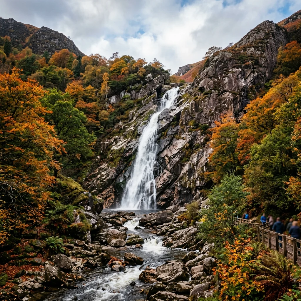
- Height: 121 m (397 ft), Ireland’s second highest
- Irish name: Eas Chonaill
- Type: Horsetail-fan, flows all year
- River: Dargle
- County: Wicklow
- Distance from Dublin: ~30 km to the falls
- Owner: Powerscourt Estate (paid entry)
- Best time: After heavy rain
Ice carved a deep corrie at the head of the glen and left the Dargle’s upper valley hanging above it.
The story begins with the rocks. The Wicklow Mountains are built mainly of granite, part of the Leinster granite, the largest continuous area of granite in Ireland and Britain. It formed from molten rock that rose and cooled deep underground during the Caledonian mountain-building episode, around 400 million years ago, when the ancient Iapetus Ocean closed. As the hot granite pushed into older muddy sediments, it baked them into a ring of hard, silvery mica schist around its edges, known as a metamorphic aureole.
Powerscourt Waterfall pours over that schist. According to Geological Survey Ireland, the falls flow over schists of the Ribband Group within the aureole of the granite, and the steep outward-dipping layering of the schist, which parallels the side of the granite mass beneath, forms the surface the water cascades over. The actual contact between schist and granite lies a little way upstream. In the pools at the foot of the falls you can see both rock types among the boulders: schist with a silvery sheen, and granite with a speckled, crystalline look.
Ice did the rest. During the last ice age, glaciers flowing off the Wicklow uplands scoured out a deep basin, or corrie, at this spot, while the upper valley of the Dargle, the Glensoulan valley, was cut less deeply. When the ice melted, the river was left perched in a hanging valley, with no choice but to tumble down the steep back wall of the corrie. Geological Survey Ireland describes the Powerscourt corrie as a fine example of glacial erosion and lists the site as important both for the glacial landform and for the influence of the rocks on the shape of the waterfall.
The Dargle rises on the southern slopes of Tonduff, a 642-metre summit in the northern Wicklow Mountains, and flows through the Glensoulan hanging valley to the lip of the falls. The upper glen is ringed in a horseshoe by Maulin (570 m), Tonduff, War Hill (686 m) and Djouce (725 m), so in wet weather a large upland catchment drains towards the waterfall. Below the falls the river runs through the Glencree valley, where it is joined by the Glencree River, then flows east for about 13 km, picking up the Glencullen River and smaller streams, and reaches the Irish Sea at Bray Harbour.
The name comes from the Irish An Deargail, meaning “little red spot”, after the reddish tint of the rocks at its source. The uplands it drains are dominated by blanket bog, heath and grassland, which soak up rain and release it slowly, one reason the falls run throughout the year. Even so, flow varies enormously: after a dry summer spell the waterfall can thin to a few silver threads spreading over the rock, while after heavy rain it becomes a roaring white curtain. That is why the classic advice is to visit after a wet day.
The lower Dargle has its own history. In August 1401 its banks near Bray were the scene of the Battle of Bloody Bank, when citizens of Dublin led by John Drake defeated a raiding army of the O’Byrne and O’Meagher clans; the slaughter was so great that the spot kept the name Bloody Bank until it was renamed Sunny Bank in the 19th century. By the 18th and 19th centuries the wooded glen of the Dargle was a fashionable picnic spot, and Dubliners spoke of their holidays as “Dargle days”. Sir Walter Scott visited in 1825 and later used “dargle” in his novel Redgauntlet, apparently believing it meant any glen.
A Norman castle, a Palladian mansion, a fire and a restoration.
Powerscourt takes its name from the Anglo-Norman La Poer family, later anglicised to Power, whose 13th-century castle controlled access to the Dargle, Glencree and Glencullen valleys. In the early 17th century the lands passed, amid a violent feud with the local O’Toole family, to Sir Richard Wingfield, and the Wingfields, later Viscounts Powerscourt, held the estate for more than three centuries.
Between 1731 and 1741 Richard Wingfield, 1st Viscount Powerscourt, had the architect Richard Cassels (also spelled Castle) remodel the medieval castle into a grand Palladian country house with a severe facade framed by two domed towers. In the 19th century Mervyn Wingfield, 7th Viscount Powerscourt, who inherited as a boy in 1844, created the famous terraced gardens, inspired by visits to Versailles, Schönbrunn and Schwetzingen; the work took about 20 years and was completed in 1880. In 1961 the 9th Viscount sold the estate to the Slazenger family, founders of the sporting goods company, who still own it. The house was gutted by fire on 4 November 1974 and stood as a shell until it was renovated in 1996.
The waterfall has its own story from this era. When King George IV visited Ireland in August 1821, Richard Wingfield, 5th Viscount Powerscourt, had the river dammed above the falls so that a spectacular torrent could be released while the king watched from a bridge below. The king never left the banquet to see it, which was just as well: when the water was finally let go, the surge swept the bridge away.
In 1858 the 7th Viscount turned the land around the waterfall into a deer park, and it was here that Japanese sika deer were successfully introduced to Ireland. The waterfall and its valley are still owned by the Powerscourt Estate, but they are no longer directly connected to the house and gardens. The glen has also had a long screen career, appearing in the film Excalibur (1981), in scenes of Willow (1988) and in the television series Vikings.
Sika deer, woodland and upland birds, and a fast, clean mountain stream.
The most visible animals are the sika deer descended from the 1858 introduction. Sika are small Asian deer, spotted in summer, and in Britain and Ireland they have a habit of freezing or lying flat to hide when disturbed, where red deer would run. Their spread from Powerscourt across Wicklow has created a conservation problem, because sika can hybridise with the native red deer where the two meet, and research ranking the impacts of introduced mammals in Europe placed sika among the most damaging. Wicklow’s red deer are therefore a focus of concern for wildlife managers.
The wooded slopes of the glen mix broadleaved trees with conifers planted by the estate, and the woods hold typical Irish woodland birds such as jays and treecreepers. On the river, look for dippers bobbing on rocks and grey wagtails flicking along the water’s edge, both specialists of fast upland streams. Above the glen, the open Wicklow uplands support birds of prey including merlin and peregrine falcon, and ravens are common over the ridges.
The wider Wicklow uplands are protected: the entire upland area is designated as a Special Area of Conservation and a Special Protection Area under European Union law, and the Wicklow Mountains National Park was established in 1991. The waterfall itself sits on private estate land rather than inside the national park, but it is part of the same landscape of bog, heath and wooded glens.
Ireland is not a country of giant waterfalls. Its mountains are old, worn down and relatively low, the highest summit barely tops 1,000 metres, and most rivers reach the sea without dramatic drops. The tallest falls are found where ice carved steep corries and hanging valleys into upland plateaus, which is exactly the setting of Powerscourt.
The record holder is Sruth in Aghaidh an Aird, sometimes called the Devil’s Chimney, in the Dartry Mountains on the border of Counties Sligo and Leitrim. It drops about 150 metres in two stages from the edge of a plateau into Glencar Lough, but it flows for only around 200 days a year and can dry to almost nothing in summer. Its Irish name means “stream against the height”, because strong southerly winds sometimes blow the falling water back up and over the cliff edge. A public trail now leads close to its base.
Powerscourt’s claim to fame is therefore a combination of height and reliability: it is the tallest Irish waterfall that runs all year, and by far the most accessible of the big falls, with a car park at its foot. Elsewhere in Wicklow, Glenmacnass Waterfall tumbles down a long rock slope beside the Military Road north of Laragh, and in Kerry, Torc Waterfall near Killarney is one of the most visited falls in the south-west. Neither approaches Powerscourt’s single sweep of water down the corrie wall.
Drive or take a tour; there is an entry fee and seasonal hours.
The waterfall has its own visitor entrance, separate from Powerscourt House and Gardens, and is about 7 km from Enniskerry village by narrow road. Enniskerry is about 24 km south of Dublin city centre, linked to the N11 by the steep R117 known as the Twenty-One Bends, so the falls are typically 40 minutes to an hour from central Dublin by car. Public transport reaches Enniskerry, but the regular bus link from the estate to the waterfall ended in 2005. Walking the road from Enniskerry is possible but not recommended, because long stretches are narrow with no verge.
At the base of the falls there is car parking, a picnic and barbecue area and refreshment concessions, and a short path leads from the car park to the foot of the falls. The waterfall park has set opening hours that change through the year, and it can close in severe weather, so check the estate’s website before travelling. Allow about an hour at the falls, or half a day if you also visit the house and gardens.
For a wilder view, the waterfall can be seen from Ride Rock in Crone Woods, a forest on the northern side of the glen with trails up to the summit of Maulin. The Maulin Circuit, a hill walk of about 7 km that takes around three hours, links Crone Woods, Maulin and views over the falls. Wear boots and take a map: the Wicklow uplands are boggy and weather changes fast.
Each season changes the scene. Spring brings fresh green to the broadleaved trees and strong flows after winter rain; summer is the busiest time, with families picnicking on the grass below the falls, though the water can run low in a dry spell; autumn turns the glen gold and russet and is the season of the sika deer rut, when stags call from the woods; and winter, when the park is quietest, can bring the most powerful flows of the year. Photographers often prefer an overcast day, when soft light avoids harsh contrast on the white water.
Do not climb on the rocks around the falls. The schist is smooth, wet and slippery, and people have been injured here. Swimming in the pools is not recommended either; the water is cold and the rocks are treacherous. Keep dogs under control near deer, and take litter home from the picnic area.
Powerscourt combines well with a day in the Wicklow Mountains. Glendalough, the monastic site founded by Saint Kevin in the late 6th century, is less than an hour’s drive south through the mountains, and the Sally Gap road crosses the bogs at about 500 metres. Back on the coast, Bray, where the Dargle meets the sea, has a promenade and the cliff walk to Greystones. For more of Ireland’s Atlantic and Irish Sea coast, see Dublin and the Cliffs of Moher.
- Waterfall height: 121 m
- Powerscourt House: 1731–1741, architect Richard Cassels
- House fire: 1974; restored 1996
- Sika deer introduced: 1858
- River mouth: Bray Harbour, Irish Sea
How tall is Powerscourt Waterfall?
121 m (397 ft). It is often called Ireland’s highest, but Sruth in Aghaidh an Aird in Sligo–Leitrim, about 150 m, is taller though it flows only part of the year.
Where is Powerscourt Waterfall?
On the Powerscourt Estate in County Wicklow, about 7 km from Enniskerry, with its own entrance separate from the house and gardens.
How far is Powerscourt Waterfall from Dublin?
About 30 km from Dublin city centre, typically 40 minutes to an hour by car.
Is Powerscourt Waterfall free?
No, there is an entry fee for the waterfall park, separate from the house and gardens.
Can you swim at Powerscourt Waterfall?
Swimming and climbing are not recommended; the rocks are slippery and the water cold.
What river feeds Powerscourt Waterfall?
The River Dargle, which rises on Tonduff and reaches the sea at Bray.
When is the best time to see the waterfall?
After a spell of heavy rain, when the flow is strongest; in dry weather it can thin to a few streams.
- Powerscourt Estate: Waterfall and gardens visitor information.
- Geological Survey Ireland: Powerscourt Waterfall county geological site (Ribband Group schist, granite aureole and corrie).
- National Parks and Wildlife Service: Wicklow Mountains National Park; sika deer in Ireland.
- Wikipedia: Powerscourt Waterfall; Powerscourt Estate; River Dargle; Enniskerry; Wicklow Mountains; Sika deer; Sruth in Aghaidh an Aird.
Blane Perun has been exploring Earth’s oceans and marine life for over 25 years. Founder of TheSea.Org in 1999, underwater photographer, coral aquaculture pioneer, and explorer of 80+ countries.
About Blane Perun → More from Europe Atlantic →