Albufeira — Fishing Town Turned Algarve Beach Capital
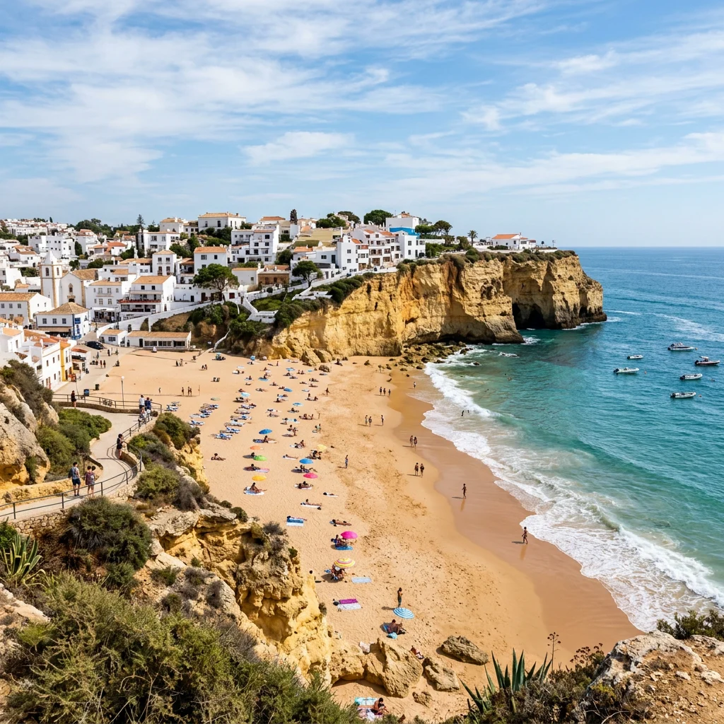
Albufeira is the Algarve’s largest resort town, a municipality of about 44,000 people on Portugal’s south coast that swells many times over in summer. Its name comes from the Arabic al-Buhayra, “the lagoon”. The whitewashed old town sits above Praia dos Pescadores, and east of town the red and ochre cliffs of Praia da Falésia run for several kilometres. Boat trips from the marina see common and bottlenose dolphins on most summer days.
The Algarve coast faces the Atlantic close to where it meets the Mediterranean at Gibraltar, so its waters mix species from both. Short-beaked common dolphins are the most frequent cetaceans on boat trips, followed by bottlenose dolphins; other cetaceans, including the Iberian orcas that follow bluefin tuna, are recorded less often. Underwater, the limestone reefs off Albufeira host octopus, cuttlefish, moray eels and sea bream. Near Faro, about 45 km east, the Ria Formosa lagoon was once home to one of the densest seahorse populations in the world.
Albufeira is the largest resort town on Portugal’s Algarve coast: a whitewashed former fishing town on a limestone cliff, flanked by sandy coves to the west and by the long red and ochre cliffs of Praia da Falésia to the east. The municipality had 44,158 residents at the 2021 census, but hotels, villas and apartments push the number of people in town to something like 300,000 in the peak of summer and over Christmas and New Year.
That contrast is the key to understanding the place. Off season it is a quiet Atlantic town of steep lanes, fish restaurants and boats pulled up on the sand. In July and August it is one of the busiest beach destinations in southern Europe, with a nightlife strip, packed beaches and dozens of boats a day heading out to look for dolphins and sea caves. This guide covers both: the history that shaped the old town, the beaches and cliffs, sea conditions through the year, the dolphins and other marine life offshore, the collapse of the Algarve’s famous seahorse population, and the rules that now govern boat trips to the caves.
Albufeira — at a glance
- Country: Portugal
- Region: Algarve, Faro District
- Population: 44,158 municipality; 28,645 city (2021 census)
- Area: 140.66 km², four civil parishes
- Name: From Arabic al-Buhayra, “the lagoon”
- Coast: Atlantic, south-facing
- Famous beaches: Pescadores, Túnel (Peneco), Falésia, São Rafael
- Distances: Faro about 45 km, Lisbon about 250 km
Albufeira sits roughly in the middle of the Algarve’s south-facing coast, about 45 km west of Faro, the regional capital, and about 30 km east of Lagoa. Lisbon is around 250 km to the north-west. The municipality covers 140.66 square kilometres and, since a 2013 reform, is divided into four civil parishes: Albufeira e Olhos de Água on the coast, and Ferreiras, Guia and Paderne inland. Most visitors never leave the coastal parish, but the hinterland holds some of the area’s oldest monuments, including the ruined Moorish castle of Paderne.
The town itself has two very different centres. The old town, or Cidade Velha, is the historic core on the cliff above the town beaches, with a pedestrian square, narrow lanes and the main churches. About two kilometres to the east, the district of Areias de São João grew up around Avenida Francisco Sá Carneiro, known to almost everyone simply as the Strip, lined with bars, restaurants and open-air clubs. Between and beyond them, hotel and apartment developments have climbed the hills behind the coast since the 1960s, and the marina sits in a former inlet on the western side of town, where most dolphin and cave trips depart.
Settlement here is old. Research points to prehistoric origins, and the Romans occupied the site under the name Baltum, building roads, bridges and aqueducts and farming the fertile land behind the coast. After Rome fell the region passed to the Visigoths, and in the early 8th century it was taken by Muslim forces from North Africa. The modern name comes from the Arabic al-Buhayra, meaning “the lagoon”, after a lagoon that formed in the lowlands. It is often translated in tourist literature as “castle on the sea”, but that is a later embellishment rather than the meaning of the word.
Under Moorish rule the town was heavily fortified, and it held out longer than most of what is now Portugal. Military orders such as the Templars and Hospitallers attacked it without success. Only after the fall of Faro did its position become hopeless, and Albufeira was taken in 1249 by the forces of King Afonso III, who granted the land to the Order of Aviz in 1250. The Cross of Aviz still appears above the main arch of the parish church. Local tradition holds that the last defenders were hunted into a cave at the western end of the seafront, the Xorino Grotto, which can still be seen from the promenade. King Manuel I granted the town a charter, or foral, on 20 August 1504.
The worst disaster in the town’s history came on 1 November 1755, when the great Lisbon earthquake and its tsunami struck the whole Algarve. Waves around 10 metres high swept into Albufeira and destroyed almost every building along the shore; only 27 houses in the town were left standing, all of them damaged. Many residents had taken shelter in the parish church, a former mosque, and its collapse killed 227 people. Aftershocks continued for months, slowing reconstruction. The town was hit again in July 1833, during the Liberal Wars, when the absolutist guerrilla leader Remexido attacked it, burning buildings and killing many inhabitants.
Recovery in the 19th century came from the sea. Fishing grew steadily, and in the first decades of the 20th century the export of fish and nuts was the backbone of the local economy. Five factories in the town employed between 700 and 800 people, most of them fishermen’s wives. Between 1930 and 1960 that economy collapsed: factories closed, the fishing fleet shrank, houses were abandoned and the population fell by about half. The town’s annual fish festival still celebrates the industry that rebuilt it.
Tourism arrived in the 1960s and changed everything. Faro International Airport was inaugurated on 11 July 1965, opening the Algarve to package holidays from northern Europe, and Albufeira grew faster than almost anywhere else on the coast. Much early building happened outside any effective planning framework, which explains the dense, uneven sprawl on the hills. Today tourism and commerce dominate the local economy, and the Algarve as a whole receives several million visitors a year.
The old town is the reason to stay in Albufeira rather than in a resort complex. White houses with coloured trim climb the cliff above the seafront, with the main square, Largo Engenheiro Duarte Pacheco, as its social centre. Its symbol is the Torre do Relógio, a 19th-century clock tower on Rua Bernardino de Sousa crowned with a wrought-iron frame that holds a single bell. The town council treats it as its emblem, and it is lit up on feast days.
The main parish church, Igreja Matriz de Nossa Senhora da Conceição, was begun in 1782 and consecrated in 1800 to replace the church destroyed in 1755. It is a plain neoclassical building with a single nave and four side chapels, and the altar painting is by the local artist Samora Barros, whose name also appears on the municipal art gallery in the town’s former power station. The old town hall now houses the Municipal Archaeology Museum, with finds from the Roman, Moorish and later periods.
One of the old town’s quirks is the tunnel that gives Praia do Túnel its name: a passage about 20 metres long, near the tourist office, cut through the cliff to link the town square directly with the beach below. Lifts, ramps and steps also lead down to the sand. At the western end of the beach a promenade runs to the Xorino Grotto, and at the eastern end of the seafront lies Praia dos Pescadores, the fishermen’s beach, where painted boats are still drawn up on the sand outside the summer season.
Town beaches for convenience, cliff coves for scenery, and Falésia for a long walk.
| Beach | Character | Best for |
|---|---|---|
| Praia dos Pescadores | Town beach below the old town, eastern end | Easy access, fishing boats |
| Praia do Túnel (Peneco) | Town beach reached by the cliff tunnel | Old-town stays, lifeguards |
| Praia da Falésia | Near 6 km of sand below red to white cliffs | Walks and photography |
| Praia de São Rafael | Small cove with rock stacks | Snorkelling, scenery |
| Praia da Coelha | Sheltered cove | Families |
| Praia da Galé | West of town, rocky reefs | Quieter swims |
The two town beaches, Pescadores and Túnel, form one continuous seafront below the old town. They are the easiest beaches to reach, have lifeguards in the summer season, and are the most crowded. For something more dramatic, the coast west of town breaks into small coves between limestone stacks and arches, such as São Rafael, Coelha and Castelo. These are the best places near Albufeira for a mask and snorkel on calm days, because rock reefs run out from the cliffs into clear water.
East of town, Praia da Falésia (“cliff beach”) is part of a nearly continuous stretch of sand almost 6 km long that runs towards Vilamoura. The cliffs behind it shift in colour from deep red to almost white, topped by green umbrella pines. At the western end they are high but soft, made of sand and clay, and rain carves them into gullies and pinnacles; towards the east they lose height but stay deeply eroded. That erosion is what keeps the beach supplied with sand. Small cones of sand at the foot of the cliffs support dune plants such as sea daffodil, sea bindweed and sea holly. Access is mainly from the Açoteias and Alfamar resorts, each with parking a few hundred metres from the beach.
The same softness that makes these cliffs beautiful makes them dangerous. Algarve cliffs shed rock and sand without warning, especially after winter rain. In August 2009 a rockfall at Praia Maria Luísa, east of Albufeira, killed five people on the beach. Lie well back from the cliff base, keep off the cliff edges above, and respect the warning signs and cordoned-off areas that the authorities put up after falls.
Albufeira has a Mediterranean-type climate with hot, almost rainless summers and mild, wetter winters. Met Office averages give daytime highs of about 16°C in January and about 29°C in July, with roughly 485 mm of rain a year, most of it between October and March; June to August each average less than 5 mm. Annual sunshine is close to 3,000 hours, among the highest totals in Europe.
The sea lags behind the air. Because this is open Atlantic rather than Mediterranean water, it is cooler than many visitors expect. Long-term averages put the coldest water, around 15 to 17°C, in late February, and the warmest, around 21 to 23°C, in mid-August, with readings still close to 19 to 20°C in early November. Summer upwelling, when north-westerly winds push surface water offshore and draw cold water up from below, can drop the temperature several degrees overnight.
For most visitors the sweet spot is late May to June or September to early October: the sea is warm enough to swim, the dolphin and cave boats run full schedules, and prices and crowds are lower than in July and August. Winter suits walkers and birdwatchers. Spring brings one of the town’s best-known sporting events, the Almond Blossom Cross Country, an international race held each year since 1977.
Yes. Dolphin-watching boats from Albufeira Marina find them on most summer trips.
The cetaceans most often seen off the Algarve are the short-beaked common dolphin and the common bottlenose dolphin. Common dolphins are the usual sighting from Albufeira: fast, slender animals with an hourglass pattern of yellow and grey on their flanks, often travelling in groups of dozens and readily riding the bow wave of a boat. Bottlenose dolphins are larger and plainer grey, and tend to be seen in smaller groups. Several other species are recorded in Algarve waters at different times of year, and the Iberian population of orcas, which follows Atlantic bluefin tuna along the coast, passes through the region; since 2020 those orcas have become known for interactions with the rudders of sailing yachts along the Iberian coast.
The water off Albufeira is productive because the continental shelf is narrow and seasonal upwelling brings nutrients to the surface, feeding sardines and other small schooling fish. Dolphins follow those shoals, which is why trips often find them feeding a few miles offshore, sometimes alongside diving gannets and shearwaters.
Whale and dolphin watching in mainland Portugal is regulated by Decree-Law 9/2006. Commercial boats need a licence and must approach animals slowly from behind and to the side, rather than head-on or cutting across their path. No more than three vessels may stay within 100 metres of a group at once, and boats must leave after about 30 minutes with the same animals. Portuguese authorities have stepped up inspections of tour boats in recent years, and passengers who pressure crews to get closer can themselves be fined. A good operator will brief you on these rules before leaving the marina; if a skipper chases, crowds or circles dolphins, choose a different company next time.
The seabed close to Albufeira is a patchwork of sand and eroded limestone reef, the underwater continuation of the cliffs on shore. Snorkellers in the coves west of town can expect sea bream, wrasse, blennies and gobies around the rocks, with octopus, cuttlefish and moray eels in the cracks for those who look carefully. Seagrass meadows and sandy patches hold flatfish and rays. Because the Algarve faces the Atlantic close to the Strait of Gibraltar, its waters mix Atlantic and Mediterranean species, and warm-water fish become more common in late summer.
Visibility varies a great deal. On calm days after a spell of light winds it can be excellent; after westerly swells or strong winds the water clouds quickly. Local dive centres run boat dives to reefs and to artificial structures off the central Algarve, but conditions are best checked on the day. Lifeguarded town beaches use the standard flag system, and swimmers should respect red flags and avoid the base of cliffs and rock stacks when the swell is running.
The Ria Formosa lagoon east of Faro once held some of the densest seahorse populations recorded anywhere, then lost most of them.
Around Faro, roughly 45 km east of Albufeira, the Ria Formosa is a lagoon system of barrier islands and salt marsh, protected as a natural park and a Ramsar wetland, that connects to the sea through six inlets. In surveys in 2001 and 2002 it held two species, the long-snouted seahorse (Hippocampus guttulatus) and the short-snouted seahorse (Hippocampus hippocampus), at the highest densities recorded for either species anywhere in the world. For the long-snouted seahorse, density in the 2001/2002 census was around 0.09 animals per square metre.
Repeat surveys in 2008 and 2009 found a collapse. Research by Project Seahorse and the University of the Algarve, published by Caldwell and Vincent in 2012, reported a decline in density of 94 percent for the long-snouted seahorse and 73 percent for the short-snouted species. The Oceanario de Lisboa, which supported later work, summarises the change as a fall from an estimated 2 million seahorses in 2002 to around 300,000 in 2008. Neither species was being fished commercially at the time, which made the crash puzzling. Loss of the seagrass and other holdfasts the animals cling to is the leading explanation, and researchers found a link between heavy boat traffic and lower seahorse density, though warmer water, food supply and predators could not be ruled out.
The story did not end there. Surveys between 2010 and 2013 found a partial rebound, with long-snouted seahorse density back to around 0.05 per square metre, still well below the early-2000s peak. Researchers also tested artificial holdfast structures, placed at four sites in the lagoon, and found seahorses settling on them at high densities, a promising tool for habitat recovery. Later surveys, however, recorded densities back down to levels similar to 2008 and 2009, and scientists working in the lagoon have attributed this relapse largely to illegal fishing to supply the dried-seahorse trade. The Ria Formosa seahorses remain a conservation priority rather than a success story. Day trips from Albufeira to Faro, Olhão or Tavira take you to the lagoon, but seahorses should only be looked for on guided, low-impact outings that do not handle the animals.
Many boat trips from Albufeira head west along the cliffs to the sea caves of neighbouring Lagoa, above all the Algar de Benagil, a cave whose roof has collapsed to leave a circular skylight over a small hidden beach. The coast between Albufeira and Lagos is full of grottoes and arches cut by the sea into the limestone, and powerboat trips are the main way to see them; many combine a cave run with dolphin watching.
Benagil became so popular that the authorities introduced new rules in August 2024. Swimming into the caves, or entering on floats and other flotation devices, is now prohibited, and private individuals and companies may no longer land on or use the sand inside the Benagil cave. Unguided kayak rental around the caves is banned, guided kayak tours need one guide kayak for every six visitor kayaks, and there are caps on the number of boats and kayaks inside the caves and limits on visit length. Operators who break the rules face heavy fines. In practice this means you see Benagil from a boat or a guided kayak rather than standing on its beach, and that the experience is calmer and safer than it was in the crowded summers before the rules.
Most visitors fly into Faro International Airport and reach Albufeira by road in well under an hour, using the A22 motorway or the older EN125 coast road. Buses link the town with Faro and other Algarve towns. The railway station, Albufeira-Ferreiras, lies several kilometres inland at Ferreiras on the Algarve line, so a bus or taxi is needed for the last stretch to the coast. Inside town, the old town and the seafront are best explored on foot, though the hills are steep; a tourist train and local buses connect the old town, the marina and the Strip.
Choose where to stay according to what you want from the trip. The old town is walkable, atmospheric and close to the town beaches, but busy and noisy in midsummer. The Strip and the Oura area suit nightlife. Quieter resort areas such as Olhos de Água and the clifftop developments around Falésia suit families and anyone who wants long beach walks. Just west of the municipality, the Salgados Lagoon at the mouth of a small river near Armação de Pêra is classified as an Important Bird Area and is a good change of scene for birdwatchers, with wetland species that are hard to see elsewhere on this stretch of coast.
For food, the local specialities come from the sea. Cataplana is a rich steamed stew of local shellfish, named for the hinged copper pan it is cooked in, and caldeirada fish stew and simple grilled sardines are on menus all over the old town. Eating fish that has been landed locally, and asking where it comes from, is one small way visitors can support the fishing tradition that built the town.
Is Albufeira worth visiting?
Yes, for its old town, beaches, cliffs and boat trips. It is very busy in July and August, so late spring and early autumn are more relaxed.
Can you see dolphins in Albufeira?
Yes. Boat trips from the marina usually find short-beaked common dolphins, and sometimes bottlenose dolphins, especially in the warmer months.
What is the best beach in Albufeira?
Praia da Falésia for scenery and long walks; Praia dos Pescadores and Praia do Túnel for convenience; the western coves for snorkelling.
Is the sea warm in Albufeira?
It is Atlantic water: about 15–17°C in late winter and 21–23°C at its warmest in mid-August.
How far is Albufeira from Faro airport?
Roughly 40 to 45 km by road, usually 30 to 45 minutes depending on traffic.
What does Albufeira mean?
It comes from the Arabic al-Buhayra, meaning “the lagoon”. The popular translation “castle on the sea” is not accurate.
Can you land on the beach inside Benagil cave?
No. Since August 2024 landing on the sand inside the Benagil cave and swimming into the caves are prohibited; visits are by boat or guided kayak.
- Instituto Nacional de Estatística (Portugal): Census 2021 results for Albufeira municipality.
- Wikipedia: Albufeira; Praia do Túnel (Peneco); Falésia Beach; Ria Formosa; Algarve (history, monuments, beaches and wildlife).
- Met Office: climate averages for Albufeira; Surf-forecast.com: Albufeira sea temperature averages.
- Caldwell, I. R. & Vincent, A. C. J. (2012). Revisiting two sympatric European seahorse species: apparent decline in the absence of exploitation. Aquatic Conservation 22(4): 427–435.
- Stacy, R. et al. (2021). The paradox of retained genetic diversity of Hippocampus guttulatus in the face of demographic decline. Scientific Reports 11: 10434.
- Oceanário de Lisboa: Seahorses in Ria Formosa, endangered?
- Decree-Law 9/2006 (Portugal): rules for cetacean watching in mainland Portuguese waters.
- The Portugal News (August 2024): new Algarve cave access rules come into force.
Blane Perun has been exploring Earth’s oceans and marine life for over 25 years. Founder of TheSea.Org in 1999, underwater photographer, coral aquaculture pioneer, and explorer of 80+ countries.
About Blane Perun → More from Europe Atlantic →