East China Sea — The Wide Shelf Sea Where the Yangtze Meets the Kuroshio
The East China Sea is a marginal sea of the western Pacific between eastern China, Taiwan, Korea’s Jeju Island and Japan’s Kyushu and Ryukyu Islands, covering roughly 1.25 million km² (482,000 sq mi) including the Yellow Sea, or about 770,000 km² by narrower definitions. Almost three-quarters of it is shallow continental shelf under 200 m, but along its eastern edge the Okinawa Trough plunges to 2,716 m. It is fed by China’s greatest river, the Yangtze, and bordered by the warm Kuroshio Current.
Where is the East China Sea?
The East China Sea lies off the eastern coast of mainland China, facing the provinces of Jiangsu, Zhejiang and Fujian and the city of Shanghai. On its eastern and south-eastern side it is enclosed by the middle part of what strategists call the first island chain: the Japanese island of Kyushu and the long arc of the Ryukyu Islands that runs south-west towards Taiwan. Taiwan itself closes the sea in the south. Through the Korea Strait in the north-east it connects with the Sea of Japan; through the Taiwan Strait in the south-west it opens to the South China Sea; and through the gaps between the Ryukyu islands, such as the Tokara Strait and the Miyako Strait, it exchanges water with the Philippine Sea and the open Pacific.
The northern edge is a matter of convention rather than coastline. The Yellow Sea, the shallow sea between the Korean Peninsula and northern China, is usually separated from the East China Sea by an imaginary line drawn from the south-western tip of South Korea’s Jeju Island to the eastern tip of Qidong at the mouth of the Yangtze. The International Hydrographic Organization, which publishes the standard limits of the world’s seas, describes the “Eastern China Sea (Tung Hai)” with a southern limit running from the northern point of Taiwan to the Fujian coast at about 25°24′N, an eastern limit that follows the Ryukyu chain from Hateruma and Miyako to Okinawa, Kikai and Tanegashima, and a northern limit from Kyushu through the Goto Islands to Jeju and then west along 33°17′N to the Chinese mainland.
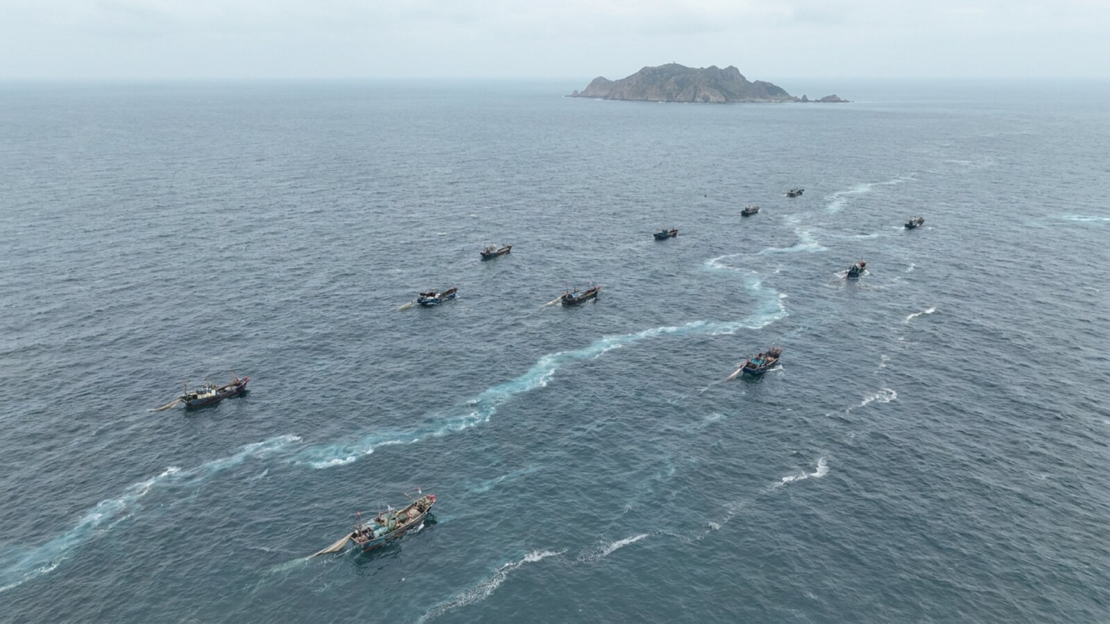
How big is the East China Sea?
Two very different figures circulate, and both are correct for their own definition. When the Yellow Sea is treated as the East China Sea’s northern arm, the combined area is roughly 1,249,000 km² (about 482,000 sq mi). When the East China Sea is counted on its own, south of the Jeju–Yangtze line, the usual figure is about 770,000 km² (about 300,000 sq mi). Neither number is more “official” than the other; they simply reflect where the boundary with the Yellow Sea is drawn. Either way, it is one of the larger marginal seas of the western Pacific, and most of its area lies over a single, unusually broad continental shelf.
The sea is also narrow relative to the claims that overlap on it. Measured across from the Chinese coast to the Ryukyus, it is only about 360 nautical miles wide. Because both China and Japan are entitled under the 1982 UN Convention on the Law of the Sea to an exclusive economic zone of 200 nautical miles, their zones cannot both fit, and that simple piece of geometry lies behind much of the political tension described below.
How deep is the East China Sea?
Most of the East China Sea is shallow. Almost three-quarters of it is less than 200 m (660 ft) deep, the average depth is about 350 m (1,150 ft), and the deepest point, in the Okinawa Trough, is 2,716 m (8,911 ft). The shallow part is the East China Shelf, a broad, gently sloping continental shelf that runs out from the Chinese coast for hundreds of kilometres before breaking off along a shelf edge that roughly parallels the Ryukyu Islands. Like the neighbouring Yellow Sea, much of this shelf stood above sea level during the low sea stands of the last ice age, when the coastline lay far to the east of its present position.
The Okinawa Trough is the sea’s deep eastern rim. It is an active back-arc basin, a zone where the crust behind a volcanic island arc is being stretched and thinned. It formed behind the Ryukyu arc-trench system, where the Philippine Sea Plate is subducting beneath the Eurasian Plate along the much deeper Ryukyu Trench on the Pacific side of the islands. The crust under the northern Okinawa Trough is about 30 km thick, but it thins to about 10 km in the south, and a large part of the trough lies deeper than 1,000 m. Geologists describe it as still being at an early stage of rifting, evolving from arc-type to true back-arc activity, and it carries submarine volcanoes such as Yonaguni Knoll IV.
That rifting feeds hydrothermal vents. Vent fields such as Iheya North in the middle Okinawa Trough support communities of vent snails, alvinocaridid shrimp and other animals that depend on chemosynthetic bacteria rather than sunlight. Researchers studying these sites have described mineral coatings on vent gastropod shells that reflect the chemistry of the local vent fluids, and metagenomic work on an undescribed glass sponge from a middle Okinawa Trough vent has found sulphur-oxidising and methane-oxidising microbes living inside it, including lineages new to science. These deep, hot, chemical habitats sit only a few hundred kilometres from one of the most densely populated coastlines on Earth.
East China Sea — key figures
| Measure | Value | Note |
|---|---|---|
| Surface area | ~770,000–1,249,000 km² | Larger figure includes the Yellow Sea |
| Width | ~360 nautical miles | Too narrow for two full 200-nm EEZs |
| Average depth | ~350 m | Almost three-quarters is under 200 m |
| Maximum depth | 2,716 m | Okinawa Trough |
| Crust under Okinawa Trough | ~30 km (north) to ~10 km (south) | Thinning back-arc basin |
| Bordering governments | 4 | China, Taiwan, South Korea, Japan |
| Main river | Yangtze (Chang Jiang) | 6,300 km, longest river in Eurasia |
How do the Yangtze and the Kuroshio shape the sea?
Two great flows of water define the East China Sea, one from the land and one from the ocean. From the west comes the Yangtze, or Chang Jiang, the longest river in Eurasia, the third-longest in the world and the longest anywhere to flow entirely within one country. It runs about 6,300 km from the Tibetan Plateau to the sea near Shanghai and is the largest river entering the East China Sea. Its fresh, sediment-laden and nutrient-rich outflow, known to oceanographers as Changjiang Diluted Water, spreads across the inner shelf as a low-salinity surface layer. Its direction depends on the wind: when southerly winds reverse the China Coastal Current in summer, the plume spreads east and north-east from the river mouth, out across the shelf.
Much of the Yangtze’s sediment does not travel far offshore. Instead of dispersing across the whole shelf, it has built an elongated subaqueous mud wedge about 800 km long and up to 60 m thick that runs south from the river mouth along the Zhejiang and Fujian coasts towards the Taiwan Strait. Where that sediment goes is controlled by the interaction of three currents: the China Coastal Current, the Taiwan Warm Current and intrusions of the Kuroshio onto the shelf.
From the south-east comes the Kuroshio, the “black current”, named for the deep blue of its clear, nutrient-poor water. It is the western boundary current of the North Pacific gyre, the Pacific counterpart of the Gulf Stream, carrying warm equatorial water poleward. It is roughly 100 km wide and has an annual average surface temperature of about 24 °C. After passing east of Taiwan, it enters the East China Sea and flows north-east along the edge of the shelf, parallel to the Ryukyu Islands, before leaving through the Tokara Strait to continue along the south coast of Japan. A branch, the Tsushima Current, splits off and flows north through the Korea Strait into the Sea of Japan.
Where the Kuroshio meets the shelf, branches of it push onto the shelf as intrusions, mixing with coastal and river water. Modelling studies of the period 1993 to 2010 have shown that the strength of these intrusions varies from year to year and depends partly on how much water the Kuroshio itself is carrying, which is set far out in the interior Pacific. The fronts between warm, salty ocean water, cooler shelf water and fresh river water are among the most productive features of the sea, concentrating plankton and the fish that feed on it.
What lives in the East China Sea?
The East China Sea is one of the most productive and heavily fished seas in the world, and its best-known animals are commercial fish. The largehead hairtail, a long, silvery, ribbon-shaped predator, is among the most important. Worldwide landings of the species were more than 1.3 million tonnes in 2009, making it the sixth most important captured fish species that year, and by far the largest catches, about 1.2 million tonnes, were reported by China and Taiwan from the north-west Pacific. Taxonomists still debate whether the hairtail of the Sea of Japan and East China Sea is the same species as the Atlantic fish; some treat it as a separate species, Trichiurus japonicus, on the basis of differences in body shape, fin-ray counts and genetics, while FishBase lumps it with T. lepturus.
The small yellow croaker, Larimichthys polyactis, tells the story of the sea’s fisheries in a single species. It is a temperate croaker of the East China and Yellow seas, commonly about 30 cm long and up to 42 cm, with red lips and a golden belly. Females spawn between March and June and release about 30,000 to 70,000 eggs. Once an abundant commercial fish off China, Korea and Japan, its population collapsed in the 1970s because of overfishing. Catches later rebounded, with 388,018 tonnes landed worldwide in 2008, and salted, dried croaker is still a prized delicacy in Korea.
The sea is also home to one of the largest jellyfish on Earth. Nomura’s jellyfish, Nemopilema nomurai, can reach about 2 m across the bell and weigh about 200 kg. It lives mainly in the Yellow Sea and East China Sea, and in June and July young jellyfish are carried out through the Tsushima Strait into the Sea of Japan, where they grow, in about six months, from the size of a grain of rice to giants. Blooms appeared to become more frequent between 1989 and 2009, and possible causes include climate change, overfishing of competitors and predators, and coastal construction that provides hard surfaces for the polyp stage. The blooms clog and burst nets, and in 2009 a 10-tonne trawler capsized off Chiba as its crew tried to haul in a net holding dozens of the jellyfish.
Along the eastern edge, the warm Kuroshio changes the character of the sea. It carries coral, fish and invertebrate larvae north from tropical reefs, and it controls the connectivity of coral reefs along the Ryukyu Arc. As a result the Ryukyu Islands have rich coral reefs that the World Wildlife Fund lists among its Global 200 ecoregions, and the islands also hold many endemic land animals. Reefs, seagrass and the black-banded sea krait are part of this tropical fringe; for reef locations, see Japan coral reef maps. The reefs are threatened by sedimentation and nutrient pollution from farming and by fishing.
The Chinese sturgeon, Acipenser sinensis, links the sea to the Yangtze. Adults grow to between 2 and 5 m long and weigh 200 to 500 kg, making them among the largest sturgeon in the world. They spend much of their lives at sea and migrate up the Yangtze to spawn, and unlike salmon they can spawn several times in a lifetime. The species is listed as Critically Endangered. In the 1970s an estimated 2,000 fish spawned in the Yangtze each year; that number fell to several hundred, after the Gezhouba Dam blocked the migration route to the upstream spawning grounds in the early 1980s. Monitoring detected no new spawning at all in 2013 and 2014. More than five million captive-bred sturgeon have been released into the river, but the wild population depends on whether natural spawning recovers.
Whales were once hunted here too. American whaling ships cruised the sea for right whales between 1849 and 1892. Today right whales are rarely seen in these waters.
Why is the East China Sea disputed?
Four governments border the sea, and their claims overlap in three main ways: over islands, over the boundary of their exclusive economic zones, and over the seabed resources beneath them.
The best-known dispute concerns the Senkaku Islands, called the Diaoyu Islands in the People’s Republic of China and the Tiaoyutai Islands in Taiwan. The group consists of five uninhabited islands and three barren rocks, ranging from about 800 m² to 4.32 km²; the largest, Uotsuri-shima, covers about 4.3 km². Japan incorporated the islands into Okinawa Prefecture on 14 January 1895, during the First Sino-Japanese War, describing them as terra nullius. Apart from a period of United States administration from 1945 to 1972 as part of the Ryukyu Islands, they have been controlled by Japan ever since. When the United States returned Okinawa to Japan in 1972, it transferred administration of the islands but took no position on sovereignty. In September 2012 the Japanese government bought three of the islands from their private owner, prompting large protests in China, and on 23 November 2013 the PRC declared an East China Sea Air Defense Identification Zone that includes the islands and requires aircraft entering it to file flight plans.
The economic-zone dispute is about how the sea floor should be divided. China argues that its continental shelf is a natural prolongation of its landmass that extends as far as the Okinawa Trough, more than 200 nautical miles from its coast, and that the trough marks the true boundary between the Chinese and Japanese shelves. Japan regards the trough as an incidental depression in a continuous margin and proposes a median line halfway between the two coasts; under that approach Japan claims about 40,000 km² of the area China also claims. China presented a submission on the outer limits of its continental shelf in the East China Sea to the UN Commission on the Limits of the Continental Shelf in 2012 and gave a presentation to the commission in August 2013, backed by surveys from 14 research ships covering about 250,000 km².
Gas makes the line matter. In 1995 China discovered the Chunxiao gas field, one of several in the Xihu Sag area that together are estimated to hold proven reserves of about 364 billion cubic feet of natural gas. Chunxiao lies on China’s side of Japan’s proposed median line, about 6 km west of it, but Japan argues that the reservoir may extend beneath the disputed area. Commercial production began in 2006. In June 2008 the two governments agreed to develop the Chunxiao fields jointly, but they have never agreed on how to carry the plan out. Further north, China and South Korea disagree over Socotra Rock, or Ieodo, a submerged reef on which South Korea has built an ocean research station; neither country claims the rock as territory, but China objects to Korean activity there as a breach of its EEZ rights.
Why does the East China Sea matter to shipping?
The Yangtze delta, at the sea’s western edge, is one of the most important economic regions in the world. It generated a GDP of about US$2.2 trillion in 2018, similar to that of Italy. Its ports face the East China Sea: Shanghai overtook Singapore in 2010 to become the world’s busiest container port and handled 43.3 million TEU in 2019, while Ningbo-Zhoushan, to the south, is the world’s largest port by cargo tonnage. The 36 km Hangzhou Bay Bridge crosses an inlet of the sea south of Shanghai. Ship traffic between these ports, Korea, Japan and Taiwan crosses the same waters that support the fishing fleets, which raises the stakes of every collision and spill.
What threatens the East China Sea?
Overfishing. Decades of intense fishing have depleted many of the sea’s stocks, as the history of the small yellow croaker shows. China introduced an annual summer fishing moratorium in 1995 in the Bohai, Yellow and East China seas, and extended it to the South China Sea north of 12°N in 1999. The ban now begins at noon on 1 May and lasts for about three to four and a half months depending on the area and type of fishing; in 2025, parts of the East China Sea reopened on 16 August, while the enforcement campaign ran to 16 September. The policy covers nearly 120,000 fishing vessels in 11 coastal provinces. Chinese officials report signs of recovery in some economically important species, but published figures on the size of those gains are limited.
Nutrient pollution and low oxygen. The heavy load of nutrients from farming, cities and industry carried by the Yangtze fuels blooms of phytoplankton off the river mouth. When the blooms die and sink, bacteria consume oxygen in the bottom water beneath the fresh surface plume, producing seasonal hypoxia. One study of cruises from 2007 to 2013 recorded a hypoxic area of about 11,150 km² in August 2013, with an estimated 5.1 million tonnes of oxygen depleted. Another analysis found that the location and size of the hypoxic zone vary from year to year with the wind, but that the decadal trend shows the oxygen depletion expanding and intensifying. A 2024 survey of the estuary’s offshore zone found the diatom Skeletonema costatum making up 98.4% of phytoplankton cells in summer and summer bottom-water oxygen as low as 2.10 mg per litre.
Dams and a shrinking delta. Dams across the Yangtze basin, culminating in the Three Gorges Dam, which closed in 2003, have sharply reduced the sediment reaching the sea. Since 2003 the front of the Yangtze delta has experienced severe erosion and coarsening of its sediments, and a comparison of bathymetric surveys from 1998 and 2013 found net erosion of about 1.85 billion m³ from the lowest 565 km of the river channel, with local scouring of the riverbed up to 10 m deep.
The Sanchi disaster. On 6 January 2018 the Iranian tanker Sanchi collided with the bulk carrier Changfeng Crystal about 300 km off Shanghai, in one of China’s most important fishing grounds. The tanker burned and drifted for eight days and sank on 14 January in about 115 m of water; all 32 crew, 30 Iranians and 2 Bangladeshis, were lost, and only three bodies were recovered. Figures for the cargo differ: the French spill centre Cedre gives 136,000 tonnes of natural gas condensate, while a 2025 chemical study gives 111,300 tonnes, plus about 1,900 tonnes of heavy fuel oil. Much of the volatile condensate is thought to have burned or evaporated, but residues of the heavy fuel oil washed ashore on 26 southern Japanese islands, including Amami-Oshima and Okinawa, from late January 2018.
Warming and shifting blooms. Habitat models for East China Sea crabs and shrimp under future climate scenarios predict that many species will shift north and offshore as the water warms, and the increasing frequency of giant jellyfish blooms, linked in part to climate change and overfishing, shows how quickly the balance of this crowded shelf sea can change.
What is the East China Sea called?
In Chinese the sea is simply the Donghai, the “East Sea”, one of the Four Seas of classical Chinese literature, one for each cardinal direction. The English name East China Sea is the form used by the International Hydrographic Organization and internationally. In Japanese it was written 東支那海 (Higashi Shina Kai, “East Shina Sea”) until the Second World War; in 2004 the Japanese Foreign Ministry and other departments switched to writing it 東シナ海, pronounced the same way, which is now standard in Japan. In Korean the same characters are read Dong Hae, a name more often used in Korea for the Sea of Japan, and in Indonesia the official name changed in 2014 from Laut Cina Timur to Laut Tiongkok Timur.
- The East China Sea covers ~770,000–1,249,000 km² of the western Pacific.
- Almost three-quarters is shallow shelf under 200 m; it reaches 2,716 m in the Okinawa Trough.
- The Yangtze and the Kuroshio shape its waters.
- It is one of the world’s most heavily fished seas.
- The Senkaku/Diaoyu islands and EEZ boundaries are disputed.
Where is the East China Sea?
It lies between eastern China to the west, Taiwan to the south, Korea’s Jeju Island to the north, and Japan’s Kyushu and Ryukyu Islands to the east, opening to the Yellow Sea, Sea of Japan, South China Sea and Philippine Sea.
How deep is the East China Sea?
Almost three-quarters of it is under 200 m deep. Its average depth is about 350 m and its deepest point is 2,716 m in the Okinawa Trough.
How big is the East China Sea?
About 770,000 km² on its own, or about 1,249,000 km² if the Yellow Sea is counted as its northern arm.
Which countries border the East China Sea?
China, Taiwan, South Korea and Japan.
What river flows into the East China Sea?
The Yangtze (Chang Jiang), the longest river in Eurasia at about 6,300 km, is the largest river entering the sea, near Shanghai.
What are the Senkaku Islands?
Five uninhabited islands and three rocks administered by Japan since 1895 (apart from US administration in 1945–1972) and claimed by China and Taiwan, which call them the Diaoyu or Tiaoyutai Islands.
What was the Sanchi oil spill?
In January 2018 the tanker Sanchi collided with a bulk carrier about 300 km off Shanghai, burned for eight days and sank, killing all 32 crew. Its condensate cargo is given as 136,000 t or 111,300 t depending on the source.
- International Hydrographic Organization. Limits of Oceans and Seas (S-23): “Eastern China Sea (Tung Hai)”.
- Wikipedia. East China Sea; Okinawa Trough; Kuroshio Current; Senkaku Islands dispute; Yangtze; Yangtze River Delta (area, depths, crust thickness, EEZ claims, Chunxiao gas, Kuroshio width and temperature).
- Hypoxia off the Changjiang (Yangtze River) Estuary and in the adjacent East China Sea (11,150 km² hypoxic area, August 2013). East China Normal University research portal.
- Liblik, T., Wu, Y. & Fan, D. (2019). Wind-driven stratification patterns and dissolved oxygen depletion in the area off the Changjiang (Yangtze) Estuary. Biogeosciences Discussions. doi:10.5194/bg-2019-421
- Deng, B. et al. (2026). Land-ocean nutrient gradients and phytoplankton in the Yangtze River Estuary EEZ. Frontiers in Microbiology. doi:10.3389/fmicb.2026.1897991
- Zheng, S. et al. (2018). Riverbed erosion of the final 565 km of the Yangtze River following construction of the Three Gorges Dam. Scientific Reports. doi:10.1038/s41598-018-30441-6
- Cedre. MT Sanchi incident information sheet (crew, cargo, sinking date and depth).
- John, G.F. et al. (2025). Chemical fingerprinting and weathering assessment of Sanchi oil tanker spill residues. Marine Pollution Bulletin. doi:10.1016/j.marpolbul.2025.117995
- South China Sea Strategic Situation Probing Initiative (2025). Three decades of China’s marine summer fishing moratorium.
- Wikipedia. Largehead hairtail; Larimichthys polyactis; Nomura’s jellyfish; Chinese sturgeon; Ryukyu Islands; Port of Shanghai.
- Liu, Z. et al. (2014). Interannual variability of the Kuroshio onshore intrusion along the East China Sea shelf break. Journal of Geophysical Research: Oceans. doi:10.1002/2013jc009653
- Xu, M. et al. (2025). Seasonal spatial distribution of Ovalipes punctatus in the southern Yellow and East China Seas and climate-scenario predictions. Biology. doi:10.3390/biology14080947
- Bonk, A. et al. (2025). Diversity of coatings on hydrothermal vent gastropods (Iheya North, Okinawa Trough). Scientific Reports. doi:10.1038/s41598-025-29638-3
Blane Perun has been exploring Earth’s oceans and marine life for over 25 years. Founder of TheSea.Org in 1999, underwater photographer, coral aquaculture pioneer, and explorer of 80+ countries.
About Blane Perun → More on Seas →