#3 Roatán Coral Reefs — Walls of the Mesoamerican Barrier Reef
Roatán ranks third because it puts the Mesoamerican Barrier Reef — the largest barrier reef system in the Caribbean and often described as the second largest in the world — a few minutes from shore. The largest of Honduras’s Bay Islands is a long, narrow island built on an ancient, uplifted coral reef. A fringing reef runs close along much of its coast and drops into steep walls, canyons and swim-throughs, with sponges, sea fans and hard corals, a purpose-sunk wreck and a regular dive with Caribbean reef sharks. Since 2005, the community-founded Roatán Marine Park has patrolled and protected the most heavily used stretch of reef.
Roatán combines big-reef structure with easy access and a long history of local stewardship. This page explains why it ranks third on our list, how its reef is built, the best dives, the animals you can expect, and the threats and protections shaping the reef today. For practical trip planning, see our Roatán travel guide; for the wider country map, see Honduras coral reef maps.
Why Roatán ranks #3
Access, variety and community-led protection.
The first reason is access. The reef runs so close to shore along the north and west coasts that many dives begin minutes after leaving the dock. The second is variety: within a short boat ride there are shallow coral gardens suitable for a first open-water dive, near-vertical walls, cracks and swim-throughs, a wreck and a shark dive. The third is stewardship. Long before the national marine park existed, resort owners, dive operators and fishers on the west end set up their own reserve, and that community-led approach still shapes how the reef is managed.
The ranking is not a claim that the reef is pristine. Like every Caribbean reef, it has lost coral to bleaching, hurricanes, disease and the decline of grazing animals, and it carries heavy diving and cruise traffic. What sets it apart is the combination of a large, structurally complex reef, very easy access and an unusually organised local effort to protect it. Roatán edges out Cozumel, on the same reef system, for its mix of walls, sharks and community protection; Cozumel wins for drift diving.
Roatán and the Mesoamerican Reef
An island of old reef limestone on the edge of a 1,100 km reef system.
Roatán lies between Utila and Guanaja, about 65 km off the Honduran mainland. Published measurements of its length vary from about 59 to 77 km, and it is less than 8 km wide. Most infrastructure, dive resorts and the busiest reefs are on the western half; the easternmost quarter, Helene or Santa Elena, is separated by a narrow channel cut through mangrove forest. Geologically, the island rests on an exposed ancient coral reef, so the ridge that forms its spine is old reef limestone lifted out of the sea.
The living reef around it is part of the Mesoamerican Barrier Reef System, which stretches more than 1,126 km (700 mi) from Isla Contoy off the Yucatán Peninsula, past Cozumel and the long barrier of Belize, to Guatemala and the Bay Islands. The system supports more than 65 species of stony coral and more than 500 fish species, and the IUCN Red List of Ecosystems classifies it as critically endangered.
Reef zones: from lagoon to wall
A classic fringing-reef profile, repeated around much of the island.
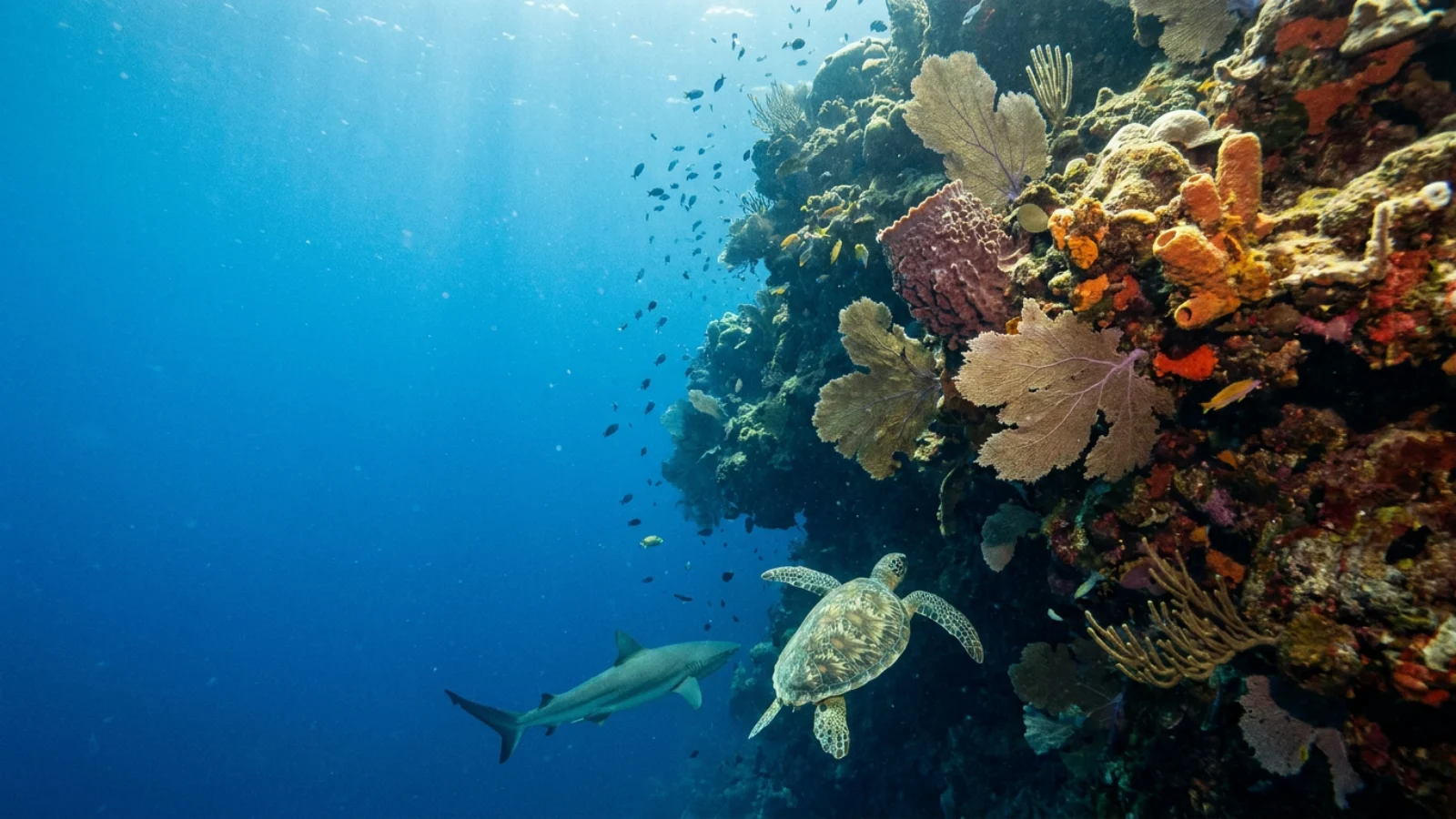
Along the north and west coasts, the reef shows distinct zones from shore to deep water: a shallow lagoon with seagrass and scattered coral heads; the reef crest, which breaks the swell; a shallow fore reef encrusted with coralline algae; a spur-and-groove zone of coral ridges separated by sand channels; and a deep fore reef that steepens into a near-vertical wall. Divers on the west end usually tie into a mooring over the shallow fore reef, swim out over the sand channels and drop over the edge, while snorkellers stay inshore in the sheltered lagoon.
The wall does not end where recreational divers stop. A 2024 study in Scientific Reports by Jacquemont and colleagues, drawing on more than a decade of submersible surveys including a continuous survey from 10 to 480 m off Roatán, found that the fish fauna changed sharply below about 150 m, and that from 300 m down a single deep-sea community took over, suggesting the lower boundary of the reef-fish world lies around 300 m.
The best reef dives on Roatán
Crevices, swim-throughs, a shark dive and a hurricane-broken wreck.
- Mary’s Place — the island’s best-known crevice dive, a deep cleft with sheer sides covered in coral and sponges, home to angelfish, parrotfish and seahorses.
- Hole in the Wall — swim-throughs and canyons cut into the reef; the deepest section is a cavern ending at about 39 m, for deep-certified divers only.
- Cara a Cara — a sand patch at about 21 m where divers kneel and watch Caribbean reef sharks.
- El Aguila — a 76 m freighter sunk as an artificial reef in 1997, now at about 33 m with groupers, barracuda and moray eels.
El Aguila’s history shows how powerful storms can be here. In October 1998, Hurricane Mitch reached Category 5 strength off northern Honduras and drifted slowly near the Bay Islands for days, breaking the wreck into three pieces. Neighbouring Guanaja took the full force, losing nearly all its vegetation, including most of its mangroves. Beyond the named sites, nearly every west-end mooring drops you onto a wall with barrel sponges, deepwater sea fans, black coral and passing spotted eagle rays. Several resorts also offer shore diving from their docks, though boat traffic is a hazard in busy bays.
What lives on Roatán’s reefs
Turtles, eagle rays, seahorses and Caribbean reef sharks.
Regular sightings include sea turtles, eagle rays, seahorses, nudibranchs, angelfish, parrotfish, butterflyfish, groupers, nurse sharks and Caribbean reef sharks, with dolphins, hammerheads and occasional whale sharks as rarer treats; whale sharks are seen more often off neighbouring Utila.
Hawksbill turtles, critically endangered sponge-eaters, are among the reef’s most important residents. Satellite tracking published in PLoS ONE in 2025 followed hawksbills tagged on nesting beaches in Honduras, Costa Rica and Panama as they migrated up to about 1,000 km to shared feeding grounds along the coasts of Nicaragua, Honduras, Belize and Mexico, so protecting reefs such as Roatán’s helps turtles that nest far away. Caribbean reef sharks benefit from national protection: in 2011 Honduras declared a shark sanctuary across its entire exclusive economic zone, described at the time as the first in the Americas, which is one reason shark dives can be run reliably.
Lionfish, disease and other threats
Invasive predators, a new coral disease and pressure from the land.
Invasive lionfish eat a wide range of small native reef fish. The Roatán Marine Park trains residents and visitors to remove them with pole spears, and a 2017 PeerJ study found that reefs culled two to three times a month had 95% lower lionfish biomass than unculled reefs and 30% higher densities of the small native fish lionfish eat. Culling has limits, though: a separate 2017 study recorded lionfish down to 250 m off West End, far beyond the reach of any spear fisher, so deep populations can resupply the shallows.
Stony coral tissue loss disease was first reported on Roatán at Flowers Bay in September 2020; over the following 13 months it affected at least 28 coral species and encircled Roatán and Utila. Local organisations, including the Roatán Marine Park, the Bay Islands Conservation Association and the Coral Reef Alliance, have worked together on monitoring and response.
Pressures from the land are just as important. Rapid tourism development and population growth have brought deforestation, runoff, poorly treated sewage and pollution. Sewer systems have been added in Coxen Hole and West End, and in 2019 the local government banned plastic bags, bottles and polystyrene. Cruise tourism adds hundreds of thousands of visitors a year. Hurricanes and marine heatwaves remain constant risks. See threats to coral reefs in the Caribbean.
How Roatán’s reef is protected
Protection that grew from the bottom up.
According to a 2024 study in Ambio by Rivera and colleagues, the islands’ marine resources had no systematic protection until the 1980s. In 1988, local fishers and resort owners created the Sandy Bay Marine Reserve through a municipal ordinance; in 1993, the West End community founded its own reserve, which soon merged with Sandy Bay’s. In 1997 an executive decree created the Bay Islands National Marine Park covering all three islands, and in 2010 a national decree made official a co-management system involving government, municipalities, businesses, ethnic groups and NGOs.
The Roatán Marine Park, a grassroots non-profit founded in January 2005 by dive operators and local businesses, began with patrols in the Sandy Bay–West End reserve and has added education, conservation, recycling and coastal clean-ups; an East End chapter followed in 2017. Rivera’s team found that satisfaction with reef management and perceived patrol effectiveness both exceeded 70% among local resource users, while compliance and local institutions still needed strengthening. Coral restoration programmes rely heavily on volunteer divers, and the Roatán Institute for Marine Sciences, founded in 1989, has long hosted research on the island’s reefs, seagrass and mangroves.
When to dive Roatán
Year-round diving, with the calmest seas in the dry season.
Water temperatures run about 25–29°C (78–84°F), so a 3 mm wetsuit is usually enough. The dry season, roughly March to September, brings clearer skies and calmer seas. Most dive resorts are on the north coast and west end, where the reef is most sheltered. Late-year storms are the main seasonal caution: slow-moving systems in the western Caribbean can disrupt diving for days, so autumn travellers should build in flexibility. The island’s international airport has direct flights from several US cities, and ferries connect Roatán with La Ceiba on the mainland and with Utila.
Is Roatán part of the Mesoamerican Barrier Reef?
Yes. It lies on the southern edge of the Mesoamerican Barrier Reef System, which runs more than 1,126 km from Mexico to the Bay Islands of Honduras.
Is Roatán good for diving?
Yes. Walls, canyons, swim-throughs, a wreck and shark dives are a short boat ride from shore, with easy shallow reefs for beginners.
Can you snorkel from the beach in Roatán?
Yes. The reef lies close to shore at West End, West Bay and Sandy Bay. Watch for boat traffic and stay in marked areas.
Can you see sharks in Roatán?
Yes. Caribbean reef sharks are seen at Cara a Cara, and nurse sharks are common. Honduras has been a national shark sanctuary since 2011.
How deep is the El Aguila wreck?
About 33 m (110 ft). The 76 m freighter was sunk in 1997 and broken into three pieces by Hurricane Mitch in 1998.
Has coral disease reached Roatán?
Yes. Stony coral tissue loss disease was first reported at Flowers Bay in September 2020 and affected at least 28 coral species within 13 months.
When is the best time to dive Roatán?
Diving runs year-round, but the dry season, roughly March to September, usually brings the calmest seas.
- Palomo P (2023). A guide to diving Roatán. PADI Blog.
- Rivera A et al. (2024). Community-based natural resource management in Roatan: strengths and challenges. Ambio.
- Peiffer F, Bejarano S, Palavicini de Witte G, Wild C (2017). Ongoing removals of invasive lionfish in Honduras and their effect on native Caribbean prey fishes. PeerJ.
- Gress E et al. (2017). Lionfish invade the upper-bathyal zone in the western Atlantic. PeerJ.
- Jacquemont J, Brandl SJ, McFarland EP, Claudet J, Baldwin CC (2024). Vertical structure of Caribbean deep-reef fishes. Scientific Reports.
- Dunbar SG et al. (2025). Hawksbill turtle migratory routes and foraging grounds in the Western Caribbean. PLoS ONE.
- Coral Reef Alliance (2023). Curbing the spread of stony coral tissue loss disease in the Honduran Bay Islands.
- Pew Charitable Trusts (2011). Honduras declares shark sanctuary.
Blane Perun has been exploring Earth’s oceans and marine life for over 25 years. Founder of TheSea.Org in 1999, underwater photographer, coral aquaculture pioneer, and explorer of 80+ countries.
About Blane Perun → More Top Ten Coral Reefs →